
Burgstall Old Castle (Oberzaunsbach)
| Burgstall Old Castle | ||
|---|---|---|
_04.JPG) Burgstall Altes Schloss - castle rocks from the north-west (December 2014) |
||
| Creation time : | Medieval | |
| Castle type : | Höhenburg, slope spur | |
| Conservation status: | Castle stable, neck ditch preserved | |
| Place: | Pretzfeld - Oberzaunsbach - "Zaunsbacher Berg" | |
| Geographical location | 49 ° 43 '26.7 " N , 11 ° 14' 29.8" E | |
| Height: | 450 m above sea level NN | |
|
||

The Burgstall Altes Schloss is a disused medieval castle on a slope spur of the Zaunsbacher Berg above the Trubach valley . It lies at 1,000 meters south-southeast of the village of Upper fence Bach in the Upper Franconian municipality Pretzfeld in Bavaria , Germany .
No historical or archaeological information is known about this castle . The castle is roughly dated to the medieval era. Only a largely naturally formed neck ditch has survived from the complex ; the site is protected as a ground monument number D-4-6233-0072: Medieval castle stables .
description
The one-piece castle site of the Spornburg is around 450 m above sea level. NN height on a rocky cliff of the Zaunsbacher Berg protruding north into the Trubach valley (Fig. 3). It is about 130 meters above the valley floor and is now densely forested (Fig. 2).
The castle rock is separated from the rising mountain slope on the southwest side of the castle site by a slightly curved railing channel about 6.5 meters deep and a maximum of 20 meters wide from the outside (Fig. 6). It runs about 45 meters from north-west to south-east. This channel, most of which was naturally formed, was used as a neck ditch and was probably deepened further in the central part, as shown by an overburden mound at both ends of the ditch on the steep slope (Fig. 4 and 5). In the northern part of this bottom ditch, an eight meter long and around 1.8 meter wide, trench-like depression can be seen, the natural or artificial origin of which is uncertain (Fig. 4 and 7).
The oval, relatively flat and about 30 by 18 meters measuring castle area is around five meters above the bottom of the trench (Fig. 8), its southern part is slightly elevated (Fig. 9). With the exception of the side bordering the moat, the castle area slopes down several meters over vertical rock walls (title picture and picture 2). Remains of the foundation wall of former castle buildings have not been found to this day. From the castle rock there is a good view of the Trubach valley, and there is also direct visual contact with the neighboring Wichsenstein castle stable .
photos
_03.JPG)

Image 3: View of the Zaunsbacher Berg from the northeast over the Trubach valley (December 2014)

Photo 4: North-western end of the ditch (December 2014)

Photo 5: South-eastern end of the ditch (December 2014)
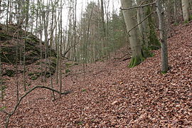
Image 6: Profile of the trench, the castle site on the left (December 2014)

Photo 7: Trench-like depression in the neck ditch (December 2014)

Photo 8: View over the slightly elevated southeast side of the castle site (December 2014)
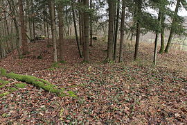
Photo 9: Northern side of the castle site (December 2014)
_01.JPG)
_07.JPG)
_08.JPG)
_05.JPG)
_06.JPG)
_10.JPG)
_09.JPG)
literature
- Walter Heinz: Former noble residences in the Trubach valley . Verlag Palm and Enke, Erlangen and Jena 1996, ISBN 3-7896-0554-9 , pp. 191-194.
- Hellmut Kunstmann : The castles of south-western Franconian Switzerland . 2nd Edition. Commission publisher Degener & Co, Neustadt an der Aisch 1990, pp. 260–261.
- Klaus Schwarz: The prehistoric and early historical monuments in Upper Franconia . (Material booklets on Bavarian prehistory, series B, volume 5). Verlag Michael Lassleben, Kallmünz 1955, p. 98.
Web links
Individual evidence
- ^ Bavarian State Office for Monument Preservation
- ↑ List of monuments for Pretzfeld (PDF) at the Bavarian State Office for Monument Preservation (PDF; 142 kB)
- ^ Location of the Burgstall in the Bavaria Atlas
- ↑ Walter Heinz: Former noble seats in the Trubachtal , p. 192 ff. And Hellmut Kunstmann: The castles of southwestern Franconian Switzerland , p. 260 f.


Castles: Ermreuth Castle | Graefenberg Castle (stone house, large house, Nuremberg nursing home) | Guttenburg Castle | Hagenbach Castle | Hallerndorf Castle (exited) | Heroldsbach Castle | New Castle (Hiltpoltstein) | Hundshaupten Castle | Jägersburg Castle | Kunreuth Castle | Pretzfeld Castle | Schellenberg Castle (exited) | Thurn Castle | Unterleinleiter Castle | Wiesenthau Castle | Wolfsberg Castle (Graefenberg) | Wüstenstein castle ruins
Castles and ruins: Bärnfels castle ruins | Bieberbach Castle (exited) | Dietrichstein Castle (exited) | Dietzhof Castle (exited) | Dörnhof Castle (exited) | Egloffstein Castle | Forchheim Castle | Gaillreuth Castle | Gößweinstein Castle | Graefenberg Castle (exited) | Hiltpoltstein Castle (Old Castle) | Kohlstein Castle | Moschendorf Castle (exited) | Neideck Castle ruins | Niederfellendorf Castle (exited) | Obertrubach Castle (exited) | Oberweilersbach Castle (exited) | Regensberg castle ruins | Reifenberg Castle (exited) | Reuth Castle (exited) | Rothenbühl Castle (exited) | Keystone Castle (exited) | Streitburg castle ruins | Thuisbrunn castle ruins | Unterleinleiter Castle | Vestenberg Castle (exited) | Wichsenstein Castle (exited) | Wolfsberg castle ruins | Wolkenstein castle ruins
Fortifications: Forchheim Fortress
Tower hill castles (all gone): Turmhügel Burk | Burgstall Ebermannstadt | Kersbach Tower Hill | Niedermirsberg tower hill | Tower Hill Rüssenbach | Tower hill Wöhr
Manor houses: Manor Dormitz (sold) | Steinhaus mansion (Dormitz) (sold) | Hammermühle Manor (sold) | Walkersbrunn manor (sold) | Wannbach manor
Castle stables (lost, unknown castles): Section fortification Altenburg | Section fortification Burggraf | Burgstall Alter Schlossberg | Burgstall Old Castle (Affalterthal) | Burgstall Old Castle (Oberzaunsbach) | Ringwall Old Castle (Drgendorf) | Section fortification Borschl | Burgstall Breitensten | Section fortification Burggraf | Burgstein Castle Stable (Peoplebach Castle?) | Ringwall Ehrenbürg | Burgstall Hainburg (Burgstall Rüsselbach, Burgstall on the cat) | Ringwall Heidelberg | Burgstall Heiliger Bühl | Burgstall Hetzelsdorf | Section fortification Hunnenburg | Section fortification Lehmberg | Burgstall Leutenbach | Ringwall Lindelberg | Burgstall Lindelburg | Section fortification Reisberg | Burgstall Retterner Pulpit | Burgstall Sattelmannsburg (Stadtmers Bürg) | Ringwall Schießberg | Burgstall Schlossberg (Haidhof) (Heidenstein) | Burgstall Thüngfelderstein (Eberhardstein Castle) | Section fortification Deep Storm | Burgstall Unterailsfeld | Burgstall Wartleiten
Fortified churches: Fortified Church Burk (Holy Three Kings) | Fortified Church Dormitz (Our Dear Lady) | Fortified church Ebermannstadt (St. Nikolaus) | Fortified church Effeltrich (St. Georg) | Fortified church Eggolsheim (St. Martin) | Kersbach fortified church (St. Johannes Baptist and St. Ottilie) | Fortified church Kirchrüsselbach (St. Jakobus) | Fortified church Langensendelbach (St. Peter and Paul) | Pautzfeld fortified church (Assumption of Mary) | Fortified church Pinzberg (St. Nikolaus) | Willersdorf fortified church (St. Bartholomäus)