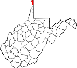
Hancock County, West Virginia
| administration | |
|---|---|
| US state : | West Virginia |
| Administrative headquarters : | New Cumberland |
| Address of the administrative headquarters: |
County Courthouse P.O. Box 485 New Cumberland, WV 26047-0485 |
| Foundation : | January 15, 1848 |
| Made up from: | Brooke County |
| Area code : | 001 304 |
| Demographics | |
| Residents : | 30,676 (2010) |
| Population density : | 142.7 inhabitants / km 2 |
| geography | |
| Total area : | 229 km² |
| Water surface : | 14 km² |
| map | |
| Website : www.hancockcountywv.org | |
Ds Hancock County is a county in the US state of West Virginia . At the 2010 census , the county had 30,676 people and a population density of 142.7 people per square kilometer. The county seat is in New Cumberland .
geography
Hancock County is located in the Northern Panhandle and is the northernmost county of West Virginia, borders Pennsylvania to the east and Ohio to the west , the border being formed by the Ohio River , and has an area of 229 square kilometers, of which 14 square kilometers are water . It borders on the following counties:
|
Columbiana County (Ohio) |
||
|
Jefferson County (Ohio) |

|
Beaver County, Pennsylvania |
| Brooke County |
Washington County, Pennsylvania |
history
Hancock County was formed on January 15, 1848 from parts of Brooke County. It was named after John Hancock (1737-1793), president of the second continental congress and co-signer of the American Declaration of Independence and first governor of Massachusetts .
Demographic data
| Population development | |||
|---|---|---|---|
| Census | Residents | ± in% | |
| 1850 | 4050 | - | |
| 1860 | 4445 | 9.8% | |
| 1870 | 4363 | -1.8% | |
| 1880 | 4882 | 11.9% | |
| 1890 | 6414 | 31.4% | |
| 1900 | 6693 | 4.3% | |
| 1910 | 10,465 | 56.4% | |
| 1920 | 19,975 | 90.9% | |
| 1930 | 28,511 | 42.7% | |
| 1940 | 31,572 | 10.7% | |
| 1950 | 34,388 | 8.9% | |
| 1960 | 39,615 | 15.2% | |
| 1970 | 39,749 | 0.3% | |
| 1980 | 40,418 | 1.7% | |
| 1990 | 35,233 | -12.8% | |
| 2000 | 32,667 | -7.3% | |
| 2010 | 30,676 | -6.1% | |
| Before 1900 1900–1990 2010 | |||
According to the 2010 census , Hancock County had 30,676 people in 13,429 households. The population density was 142.7 inhabitants per square kilometer.
The racial the population was composed of 95.7 percent white, 2.3 percent African American, 0.1 percent Native American, 0.3 percent Asian and other ethnic groups; 1.3 percent were descended from two or more races. Hispanic or Latino of any race was 1.0 percent of the population.
Statistically, 2.21 people lived in each of the 13,429 households.
20.1 percent of the population were under 18 years old, 61.1 percent were between 18 and 64 and 18.8 percent were 65 years or older. 51.6 percent of the population was female.
The median income for a household was 39,779 USD . The per capita income was $ 23,287. 14.6 percent of the population lived below the poverty line.
cities and communes
1 - partially in Brooke County
Individual evidence
- ↑ Hancock County in the Geographic Names Information System of the United States Geological Survey Accessed 22 February 2011
- ^ National Association of Counties.Retrieved October 29, 2011
- ^ US Census Bureau _ Census of Population and Housing.Retrieved February 28, 2011
- ^ Extract from Census.gov.Retrieved February 28, 2011
- ↑ United States Census 2010.Retrieved October 29, 2011
- ↑ US Census Bureau, State & County QuickFacts - Hancock County ( Memento of the original from July 11, 2011 on WebCite ) Info: The archive link was automatically inserted and not yet checked. Please check the original and archive link according to the instructions and then remove this notice. Retrieved October 29, 2011
Web links
- Official website
- Hancock County Economic Development Home Page
- US Census Bureau, State & County QuickFacts - Hancock County
- Yahoo Image Search - Hancock County
- www.city-data.com - Hancock County
Coordinates: 40 ° 31 ′ N , 80 ° 35 ′ W

