
Potomac River
|
Potomac River Cohongorooton |
||
 The Potomac catchment area includes four states and Washington, DC |
||
| Data | ||
| Water code | US : 597915 | |
| location | West Virginia , Maryland , Virginia , Washington, DC (USA) | |
| River system | Potomac River | |
| Confluence of |
North Branch Potomac River and South Branch Potomac River 39 ° 31 ′ 42 " N , 78 ° 35 ′ 16" W |
|
| Source height | 164 m | |
| muzzle | in the Chesapeake Bay Coordinates: 37 ° 59 ′ 57 " N , 76 ° 14 ′ 59" W 37 ° 59 ′ 57 " N , 76 ° 14 ′ 59" W. |
|
| Mouth height | 0 m | |
| Height difference | 164 m | |
| Bottom slope | 0.27 ‰ | |
| length | 616 km | |
| Catchment area | 6053 km² | |
| Drain at Washington, DC level |
NNQ (2008) MQ HHQ (1936) |
1.9 m³ / s 316 m³ / s 12,000 m³ / s |
| Left tributaries | Anacostia River , Antietam , Monocacy | |
| Right tributaries | Shenandoah | |
| Big cities | Washington, DC , Alexandria, VA | |
| Medium-sized cities | Leesburg, VA | |
| Communities | Harpers Ferry, WV | |
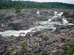
 Great Falls of the Potomac River in winter |
||
| North Branch Potomac River | ||
| Water code | US : 586218 | |
| location | Maryland , West Virginia (USA) | |
| River system | Potomac River | |
| source |
Fairfax Stone Historical Monument State Park 39 ° 11 ′ 43 " N , 79 ° 29 ′ 28" W. |
|
| Association with |
South Branch Potomac River to Potomac River 39 ° 31 ′ 42 ″ N , 78 ° 35 ′ 16 ″ W
|
|
| length | 166 km | |
| Left tributaries | Savage River , Wills Creek | |
| Right tributaries | Stony River , Abram Creek | |
| Reservoirs flowed through | Jennings Randolph Lake | |
| Medium-sized cities | Cumberland | |
| South Branch Potomac River | ||
| Water code | US : 1552968 | |
| location | Virginia , West Virginia (USA) | |
| River system | Potomac River | |
| source |
Highland County, Virginia, 38 ° 26 ′ 5 ″ N , 79 ° 37 ′ 2 ″ W. |
|
| Association with |
North Branch Potomac River to Potomac River 39 ° 31 ′ 42 ″ N , 78 ° 35 ′ 16 ″ W
|
|
| length | 224 km | |
| Left tributaries | North Fork South Branch Potomac River | |
| Right tributaries | South Fork South Branch Potomac River | |
| Small towns | Petersburg | |
The Potomac [ pəˈtoʊmək ] ( ) is a river in the eastern United States that flows into Chesapeake Bay about 616 km from its origin in West Virginia .
Its two headwaters, the North Branch Potomac River and South Branch Potomac River, unite about 15 km southeast of Cumberland on the border between Maryland and West Virginia. The river forms part of the natural boundaries between Maryland, West Virginia, Virginia and the District of Columbia in its course . Before it flows into Chesapeake Bay, the river reaches a width of 8 to 13 km. The United States Geological Survey operates a gauge in Washington, DC . There the annual mean discharge rate is 316 m³ / s. The highest value ever measured was 3944 m³ / s, the lowest was observed on February 17, 2008 with 1.9 m³ / s.
Potomac is the Europeanized spelling of Patowmeck, the Algonquian name of an Indian village. The spelling of the name has changed in many steps over the years, from Patawomeke on the map of the explorer John Smith to Patawomeck and Patowmack. In 1931 the United States Board on Geographic Names established the river's official name as Potomac.
Headwaters of the Potomac

Evening mood on the Potomac
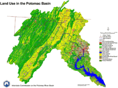
Map of the catchment area of the river


During the Civil War , the watercourse played an important role in the operations of both armies due to the frequently changing course of the front . The largest army in the Union was named Potomac Army because of its operational area .
Potomac is also the name of a riverside town in Montgomery County , about 12 miles from Washington, DC . At the place Potomac are the great waterfalls of the Potomac River.
Potomac also refers to a tribe of the Powhatan Federation that managed to unite around 30 to 40 Algonquin tribes.
The asteroid (1345) Potomac , which was discovered in 1908 by Joel Hastings Metcalf , is named after the Potomac .
literature
- Frederick Albert Gutheim: The Potomac. Johns Hopkins University Press, Baltimore 1986, ISBN 978-0-8018-3342-7 .