Interstate H-1
| Basic data | |||||||||||||||||||||||||||||||||||||||||||||||||||||||||||||||||||||||||||||||||||||||||||||||||||||||||||||||||||||||||||||||
|---|---|---|---|---|---|---|---|---|---|---|---|---|---|---|---|---|---|---|---|---|---|---|---|---|---|---|---|---|---|---|---|---|---|---|---|---|---|---|---|---|---|---|---|---|---|---|---|---|---|---|---|---|---|---|---|---|---|---|---|---|---|---|---|---|---|---|---|---|---|---|---|---|---|---|---|---|---|---|---|---|---|---|---|---|---|---|---|---|---|---|---|---|---|---|---|---|---|---|---|---|---|---|---|---|---|---|---|---|---|---|---|---|---|---|---|---|---|---|---|---|---|---|---|---|---|---|---|
| Length: | 27.16 mi / 43.71 km | ||||||||||||||||||||||||||||||||||||||||||||||||||||||||||||||||||||||||||||||||||||||||||||||||||||||||||||||||||||||||||||||
| State: |
Hawaii |
||||||||||||||||||||||||||||||||||||||||||||||||||||||||||||||||||||||||||||||||||||||||||||||||||||||||||||||||||||||||||||||
| map | |||||||||||||||||||||||||||||||||||||||||||||||||||||||||||||||||||||||||||||||||||||||||||||||||||||||||||||||||||||||||||||||

|
|||||||||||||||||||||||||||||||||||||||||||||||||||||||||||||||||||||||||||||||||||||||||||||||||||||||||||||||||||||||||||||||
|
course
|
|||||||||||||||||||||||||||||||||||||||||||||||||||||||||||||||||||||||||||||||||||||||||||||||||||||||||||||||||||||||||||||||
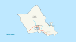
The Interstate H-1 (short- H-1 ) is an interstate highway in the state of Hawaii in the United States . It begins on Hawaii State Route 93 in Kapolei and ends in Kahala on Hawaii State Route 72 . The section east of Exit 19B is called Interstate Lunalilo Freeway and west of Exit Queen Liliuokalani Freeway . The H-1 is the westernmost interstate highway in the United States.
history
Interstate H-1 was the first freeway built in the Hawaiian Islands. The section that runs through downtown Honolulu was opened in 1953 under the name Mauka Arterial . When Hawaii became a state of the United States in 1959, the road was given the interstate designation. Only the newly built sections also meet the freeway standard of the United States, which is comparable to that of the German highways.
Important cities
Feeders and bypasses
- Interstate H-201 - also called the Moanalua Freeway .


