Interstate 19
| Basic data | |||||||||||||||||||||||||||||||||||||||||||||||||||||||||||||||||||||||||
|---|---|---|---|---|---|---|---|---|---|---|---|---|---|---|---|---|---|---|---|---|---|---|---|---|---|---|---|---|---|---|---|---|---|---|---|---|---|---|---|---|---|---|---|---|---|---|---|---|---|---|---|---|---|---|---|---|---|---|---|---|---|---|---|---|---|---|---|---|---|---|---|---|---|
| Length: | 63 mi / 102 km | ||||||||||||||||||||||||||||||||||||||||||||||||||||||||||||||||||||||||
| State: |
Arizona |
||||||||||||||||||||||||||||||||||||||||||||||||||||||||||||||||||||||||
| Course direction: | North - South | ||||||||||||||||||||||||||||||||||||||||||||||||||||||||||||||||||||||||
| map | |||||||||||||||||||||||||||||||||||||||||||||||||||||||||||||||||||||||||

|
|||||||||||||||||||||||||||||||||||||||||||||||||||||||||||||||||||||||||
|
course
|
|||||||||||||||||||||||||||||||||||||||||||||||||||||||||||||||||||||||||
The Interstate 19 (abbreviated I-19 ) runs from the Mexican border, near Nogales , until Interstate 10 in Tucson , and is just in the state of Arizona .
General information on I-19
I-19 mostly runs parallel to the former US Highway 89 .
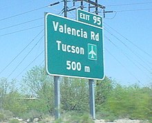
It is unique among US highways in that the signage shows distances in meters (hundreds or thousands as an indication of the distance to the exit) or kilometers (as an indication of the distance to the destination), rather than in miles, as usual. However, the speed limit signs indicate speeds in miles per hour. According to the Arizona Department of Transportation (ADOT; German: Arizona Transportation Authority), metric signs were issued based on the so-called metric system push in the United States at the time the interstate was built.
In the meantime, however, ADOT announced that it would gradually change the metric characters back to the English system , as it would be possible to avoid the high costs that would result from an immediate conversion.
Carretera Federal (federal highway) 15 begins on the Mexican side of Nogales, which leads to Mexico City and is often used not only by tourists.
Between 2002 and 2004, the intersection with Interstate 10 and the section up to Exit Ajo were rebuilt.
Web links
- Arizona Roads
- Western Exit Guide
- Larry's Phat Page ( Memento from November 27, 2010 in the Internet Archive )


