Interstate 22
| Basic data | |
|---|---|
| Length: | 325.9 km (202.5 miles ) |
| States: |
Mississippi Alabama |
| Course direction: | West East |
| map | |

|
|
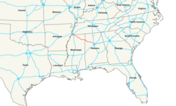
The Interstate 22 is an interstate highway in the states of Mississippi and Alabama in the United States . It connects the cities of Memphis and Birmingham over a distance of approximately 326 km.
course

Mississippi
The road begins at its western end in northern Mississippi at an interchange with Interstate 269 , approximately 26 miles southeast of Memphis, Tennessee . To the west, the I-22 is continued by the US Highway 78 , with which it is synonymous for almost its entire route until shortly before Birmingham, the road is signposted as both I-22 and US 78. From there it heads southeast, through the town of Holly Springs and through the Holly Springs National Forest . Next, the cities of New Albany and Tupelo are crossed, where the interstate is crossed by US Highway 45 . After crossing the Tennessee-Tombigbee Waterway at Fulton , the road crosses the Alabama border.
Alabama
In western Alabama, the interstate passes the city of Hamilton , crosses the Buttahatchee River and is crossed by US 278 . The next major town on the route is Jasper before I-22 crosses the Mulberry Fork and Locust Fork rivers . Shortly thereafter, US Highway 78 separates from the Interstate at Graysville at a junction with Alabama State Route 5 and heads south. From there, Interstate 22 continues for a few kilometers through wooded and suburban countryside until it ends at Interstate 65 north of Birmingham.
Web links
Individual evidence
- ↑ interstate-guide.com : Interstate 22 . Accessed March 19, 2019
- ↑ SCOH Report From Special Committee on US Route Numbering Annual Meeting . Accessed March 19, 2019 (PDF)

