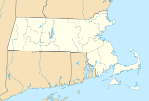
Auburn, Massachusetts
| Auburn | ||
|---|---|---|
 |
||
| Location in Massachusetts | ||
|
|
||
| Basic data | ||
| Foundation : | April 10, 1778 | |
| State : | United States | |
| State : | Massachusetts | |
| County : | Worcester County | |
| Coordinates : | 42 ° 12 ′ N , 71 ° 50 ′ W | |
| Time zone : | Eastern ( UTC − 5 / −4 ) | |
| Residents : | 16,188 (as of 2010) | |
| Population density : | 406.7 inhabitants per km 2 | |
| Area : | 42.5 km 2 (approx. 16 mi 2 ) of which 39.8 km 2 (approx. 15 mi 2 ) are land |
|
| Height : | 184 m | |
| Postal code : | 01501 | |
| Area code : | +1 508, 774 | |
| FIPS : | 25-02760 | |
| GNIS ID : | 0619474 | |
| Website : | www.town.auburn.ma.us | |
| Mayor : | Julie Jacobson | |
Auburn is a small town in Worcester County in the US state of Massachusetts .
history
The place was first settled in 1714 and founded on April 10, 1778 in honor of Artemas Ward as Town of Ward. In 1837, the city was given its current name because the United States Postal Service was confused with the Town of Ware in neighboring Hampshire County .
Rocket pioneer Robert Goddard launched his first successful launch of a liquid-propelled rocket on March 16, 1926 from his aunt Effe Ward's farm on Pakachoag Hill. Pakachoag Hill was also the seat of the main town of the Nipmuck Indians.
Personalities
- Jeffrey Lynn (1909-1995), actor
- David B. Mellish (1831–1874), politician
- Bobby Sherwood (1914-1980), musician
- Alexander Smakula (1900–1983), physicist
