Pompeys Pillar National Monument
| Pompeys Pillar National Monument | ||
|---|---|---|
| Pompey's Pillar | ||
|
|
||
| Location: | Montana , United States | |
| Specialty: | Striking rock on the Yellowstone River | |
| Next city: | Billings | |
| Surface: | 0.2 km² | |
| Founding: | January 17, 2001 | |
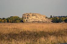
Pompeys Pillar National Monument is a memorial of the type of a National Monument in southern US state of Montana . The small sanctuary includes a striking sandstone rock on the south bank of the Yellowstone River , which is an important landmark for all travelers on and on the river. It was described by William Clark as the first white man to pass the rock on the way back of the Lewis and Clark expedition in 1806 . He named the rock after Pompey , the nickname of Jean Baptiste Charbonneau , a child of the expedition's group of only one year old at the time.
In July 1965, the rock was granted National Historic Landmark status . The area was designated in early 2001 in his last days of office by US President Bill Clinton and is under the Bureau of Land Management , an authority under the umbrella of the US Department of the Interior .
description
The boulder towering about 30 m above the Yellowstone River is an outcrop of sandstone that is about 65 to 75 million years old. It originated from sediments deposited by rivers from the Rocky Mountains as alluvial fans in a vast inland sea.
Today it stands free on the banks of the Yellowstone River, whose course is lined with poplar trees. The valley is characterized by agriculture, the biodiversity of wild animals has declined sharply since the time of William Clark. Nevertheless, the river is of great importance as a migration route for birds, especially Limikolen , ducks and geese . In the region also live white-tailed deer and mule deer , raccoons , gray fox , bobcat and coyote .
The rock has probably been used as a trail marker since the region was first settled around 11,000 years ago. In the language of the Crow Indians it is called Iishbiiammaache , which means something like "place of the mountain lion". Mountain lions or pumas are very rare in the area today. Because of its exposed location on the river, the rock is also of special importance for other peoples in the region. The Cheyenne , Lakota , Shoshone , Arapaho , Blackfeet and Salish call him in their languages . Petroglyphs in the stone show that various visitors have used the place as a resting place.
The region was part of Louisiana Territory , which the young United States bought from France in 1803. 1804-06 explored the Lewis and Clark Expedition on behalf of President Thomas Jefferson the new areas. When William Clark separated from his partner Meriwether Lewis in 1806 in order to cover a larger area on the way back from the Lewis and Clark Expedition, he was the first white man to explore the Yellowstone River. On July 25, 1806, he left his name on Pompey's Pillar. The Yellowstone River valley subsequently became part of the Crow Indian reservation .
The signature and the rock were marketed as a tourist attraction. Initially only for the passengers of the paddle steamer on the river, from 1882 the railway line of the Northern Pacific Railroad ran along the Yellowstone River and the railway company set up its own Pompeys Pillar stop . In the early 20th century, the Crow Indians were forced to downsize their reservation, but their families first had access to land in the valley under the Homestead Act , thus retaining a small portion of the land.
In 1955 the Foote family bought the rock and the fields directly adjacent to it and made it accessible to tourists again. In 1989 the business was no longer profitable, the area was bought by the Bureau of Land Management, a temporary visitor center was built and the stairs on the rocks were renewed in the following years.
In his last days in office and without voting with Congress or the state of Montana, President Bill Clinton upgraded the area to the smallest national monument in the United States in January 2001. The new visitor center opened for the 2006 summer season and presents the history of the indigenous indigenous population, the white settlers, as well as the region's nature and culture.
Web links
- Bureau of Land Management: Pompeys Pillar National Monument (official site )
- Pompeys Pillar Historical Association - a nonprofit that researches the history of the area and supports the National Monument
Individual evidence
- ↑ Listing of National Historic Landmarks by State: Montana. National Park Service , accessed August 17, 2019.


