Pemigewasset River
| Pemigewasset River | ||
| Data | ||
| Water code | US : 872478 | |
| location | New Hampshire (USA) | |
| River system | Merrimack River | |
| Drain over | Merrimack River → Atlantic Ocean | |
| source | in Franconia Notch State Park 44 ° 10 ′ 19 ″ N , 71 ° 41 ′ 13 ″ W |
|
| Union | with Winnipesaukee River to Merrimack River Coordinates: 43 ° 26 '12 " N , 71 ° 38' 55" W 43 ° 26 '12 " N , 71 ° 38' 55" W |
|
| Mouth height |
81 m
|
|
| length | 105 km | |
| Catchment area | 2644 km² | |
| Left tributaries | East Branch Pemigewasset River , Squam River | |
| Right tributaries | Baker River , Newfound River | |
| Small towns | Franklin | |
| Communities | Woodstock , Thornton , Plymouth , Ashland , New Hampton , Bristol | |
|
Course of the Pemigewasset River |
||
|
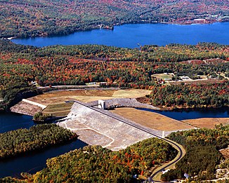
Franklin Falls Dam above Franklin |
||
The Pemigewasset River ( ˌpɛmɨdʒəˈwɑsɨt ) is the right source river of the Merrimack River in the US state of New Hampshire .
The 105 km long river drains an area of approximately 2645 km². The name "Pemigewasset" comes from the Abenaki language . The word bemijijoasek [bəmidzidzoasək] means: "side where the flow takes place".
geography
The Pemigewasset rises in Franconia Notch State Park in Franconia and flowing shortly after the profiles Lake . It flows south through the White Mountains and connects in Franklin with the Winnipesaukee River to the Merrimack River .
The Interstate 93 extends between Franconia Notch and New Hampton parallel to the river. On its course, the Pemigewasset River passes Lincoln , North Woodstock, Woodstock , Thornton , Campton , Plymouth , Ashland , Bridgewater , Bristol , New Hampton, Hill , Sanbornton and Franklin.
Along the river are several waterfalls in Franconia Notch, such as The Basin , in North Woodstock and north of Plymouth ( Livermore Falls ). The remainder of the northern part of the river from Lincoln to Ashland is an interwoven river that flows over stone steps, attracting boaters and anglers.
Below Ashland, the river to the eight-kilometer-long Ayers Island Reservoir is dammed up to generate electricity using hydropower . Below the dam there is a short section of white water before the river reaches the slower flowing water above the Franklin Falls flood retention basin . Franklin Falls Dam , built in 1943, is primarily used for flood protection .
Before the river joins the Winnipesaukee River in the center of Franklin, it drives a hydroelectric power plant again.
The catchment area of the Pemigewasset River consists of more than 1700 km of watercourses and 69 km² of lake area, including the artificially created reservoirs. It contributes about 20% to the entire catchment area of the Merrimack River.
Tributaries
The main tributaries of the river are:
- East Branch Pemigewasset River . This arm is larger and longer than the main arm of the river.
- Lost River
- Mad River
- Beebe River
- Baker River
- Squam River (outflow of Squam Lakes )
- Newfound River (outflow of Newfound Lakes )
- Smith River
Hydropower plants
There are two hydropower plants on the Pemigewasset River.
Hydroelectric power plants in the downstream direction:
| Surname | Power in MW |
Number of turbines |
location | operator |
|---|---|---|---|---|
| Ayers Island | 8.4 | 3 | ( ⊙ ) | Public Service Co of NH |
| Eastman Falls | 6.4 | 2 | ( ⊙ ) | Public Service Co of NH |
Web links
Individual evidence
- ↑ Pemigewasset River in the Geographic Names Information System of the United States Geological Survey
- ↑ New Hampshire GRANIT state geographic information system ( Memento of the original from August 3, 2013 in the Internet Archive ) Info: The archive link has been inserted automatically and has not yet been checked. Please check the original and archive link according to the instructions and then remove this notice.
- ^ William Bright : Native American placenames of the United States . University of Oklahoma Press, 2004, ISBN 978-0-8061-3598-4 , p. 376 (Retrieved April 14, 2011).
- ↑ US Army Corps of Engineers: Franklin Falls Dam
- ↑ energyjustice.net
- The Columbia Gazetteer of North America
- Merrimack River Watershed Council


