Newfound Lake
| Newfound Lake | ||
|---|---|---|

|
||
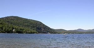
| Newfound Lake as seen from the south shore west of Bristol. | ||
| Geographical location | Grafton County in New Hampshire (USA) | |
| Tributaries | Fowler River , Cockermouth River | |
| Drain | Newfound River → Pemigewasset River | |
| Places on the shore | Bristol | |
| Data | ||
| Coordinates | 43 ° 40 ′ N , 71 ° 47 ′ W | |
|
|
||
| Altitude above sea level | 179 m | |
| surface | 16.6 km² | |
| length | 11 km | |
| width | 4 km | |
| scope | 35 km | |
| Maximum depth | 56 m | |
The Newfound Lake is a lake in the Lakes Region of New Hampshire .
With a size of 16.6 km² it is the third largest lake located exclusively in New Hampshire, after Lake Winnipesaukee and Squam Lake .
Catchment area
The water catchment area is 255.5 km². The lake has eight tributaries, the largest of which are the Fowler River and Cockermouth River . The Newfound River drains the lake and flows into the Pemigewasset River after five kilometers . On the shores of the lake are Bridgewater, Bristol, Hebron and Alexandria . Parts of Groton, Danbury and New Hampton are also within the catchment area of Newfound Lake. The lake is runoff regulated. On the south bank is the Newfound Lake Dam and a 1.4 MW hydroelectric power plant.
Special features and sights
There are two lighthouses, the Newfound Light House in Bridgewater and the 1932 Reed Light House on the west bank. There are various protected areas and parks around the lake, such as the Paradise Point Natural Area and the Charles L. Bean Sanctuary in Hebron and Wellington State Park in Bristol.
