Cockermouth River
| Cockermouth River | ||
|
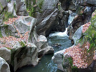
The Sculpted Rocks in Groton. |
||
| Data | ||
| River system | Merrimack River | |
| Drain over | Newfound River → Pemigewasset River → Merrimack River → Atlantic Ocean | |
| source | west of Groton 43 ° 43 ′ 56 " N , 71 ° 54 ′ 39" W |
|
| Source height | 355 m geolocator | |
| muzzle | in Hebron in Newfound Lake Coordinates: 43 ° 41 ′ 26 " N , 71 ° 47 ′ 33" W 43 ° 41 ′ 26 " N , 71 ° 47 ′ 33" W. |
|
| Mouth height | 179 m geolocator | |
| Height difference | 176 m | |
| Bottom slope | 11 ‰ | |
| length | 15.4 km | |
| Left tributaries | Wise Brook | |
| Right tributaries | Atwell Brook | |
| Navigable | No | |
The Cockermouth River is a 9 miles long creek in Grafton County , New Hampshire . It rises in the west of Groton , flows through the Sculptured Rocks Natural Area and ends in Hebron in Hebron Bay of Newfound Lake . The name comes from the former Cockermouth Grant, which after several extensions in today's Groton and to a small extent also in Hebron.
Individual evidence
- ↑ a b New Hampshire Fish Finder (English)
- ↑ New Hampshire State Parks (English)
- ↑ Hebron Historical Society (English)
Web links
Commons : Cockermouth River - Collection of pictures, videos and audio files
