
Franconia Notch State Park
|
Franconia Notch State Park
|
||
 The Pemigewassett covered bridge in Franconia Notch State Park |
||
| location | Grafton County in New Hampshire (USA) | |
| surface | 27 km² | |
| Geographical location | 44 ° 9 ′ N , 71 ° 41 ′ W | |
|
||
| Setup date | since 1971 National Natural Landmark | |
| administration | New Hampshire Dept. of Resources and Economic Development | |

The Franconia Notch State Park is a state park of the US state of New Hampshire with a size of 2,700 hectares. It lies - embedded in the White Mountain National Forest - in the north of this state. In 1972 the area was registered as a National Natural Landmark . Its main attractions include a 240-meter-long gorge , a cable car that goes to the top of Cannon Mountain (mountain) at almost 1,300 meters, and Profile Lake (lake). Known beyond the borders of New Hampshire was the Old Man of the Mountain , a natural granite formation on Cannon Mountain, which from Profile Lake looked like the jagged face of a person, but on May 3, 2003, despite it repeated attempts to rescue the valley fell.
gallery

The " Old Man " on April 26, 2003
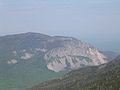
Cannon Mountain

View from Cannon Mountain to the northeast of Profile Lake

Eagle Cliff on Profile Lake , 1876 by Sylvester Phelps Hodgdon


.jpg)
References
- ↑ National Natural Landmarks (US National Park Service) .
- ↑ Created by George C. Jobel, PO Box 2482 Concord, NH 03302-2482, 603.491.4340, Lead Designer: Jody Blodgett: Franconia Notch State Park - Lincoln, NH .