Mackinac County
| administration | |
|---|---|
| US state : | Michigan |
| Administrative headquarters : | St. Ignace |
| Address of the administrative headquarters: |
County Courthouse 100 Marley Street Saint Ignace, MI 49781-1457 |
| Foundation : | 1818 |
| Made up from: | Wayne County |
| Area code : | 001 906 |
| Demographics | |
| Residents : | 11,113 (2010) |
| Population density : | 4.2 inhabitants / km 2 |
| geography | |
| Total area : | 5440 km² |
| Water surface : | 2794 km² |
| map | |
| Website : www.mackinaccounty.net | |
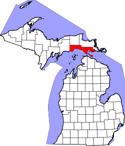
Mackinac County is a county in the state of Michigan in the United States . The county seat is St. Ignace .
geography
The county is located in the east of the Upper Peninsula of Michigan, bordering Lake Michigan to the south and Lake Huron to the southeast , both part of the 5 Great Lakes , and has an area of 5440 square kilometers, of which 2794 square kilometers are water. It is bordered clockwise by the following counties: Schoolcraft County , Luce County , Chippewa County , Cheboygan County (on Lake Huron) and on Lake Michigan the counties: Emmet County and Charlevoix Counties .
history
Mackinac County was formed in 1818 from parts of Wayne County. Until 1837 it was called Michilimackinac County . It was named after the French interpretation of the Indian expression for this area.
Three places in the county have National Historic Landmark status , the Grand Hotel on Mackinac Island , this island itself, and the St. Ignace Mission . 25 buildings and sites in the county are registered in the National Register of Historic Places (as of January 26, 2018).
Demographic data
| growth of population | |||
|---|---|---|---|
| Census | Residents | ± in% | |
| 1800 | 551 | - | |
| 1810 | 615 | 11.6% | |
| 1820 | 819 | 33.2% | |
| 1830 | 877 | 7.1% | |
| 1840 | 923 | 5.2% | |
| 1850 | 3598 | 289.8% | |
| 1860 | 1938 | -46.1% | |
| 1870 | 1716 | -11.5% | |
| 1880 | 2902 | 69.1% | |
| 1890 | 7830 | 169.8% | |
| 1900 | 7703 | -1.6% | |
| 1910 | 9249 | 20.1% | |
| 1920 | 8026 | -13.2% | |
| 1930 | 8783 | 9.4% | |
| 1940 | 9438 | 7.5% | |
| 1950 | 9287 | -1.6% | |
| 1960 | 10,853 | 16.9% | |
| 1970 | 9660 | -11% | |
| 1980 | 10.178 | 5.4% | |
| 1990 | 10,674 | 4.9% | |
| 2000 | 11,943 | 11.9% | |
| 2010 | 11,113 | -6.9% | |
| Before 1900
1900–1990 2000 + 2010 |
|||
As of the 2000 census , Mackinac County had 11,943 people in 5,067 households and 3,410 families. The population density was 5 people per square kilometer. The racial the population was composed of 80.07 percent white, 0.20 percent African American, 14.21 percent Native American, 0.31 percent Asian, 0.02 percent from the Pacific island area and 0.28 percent from other ethnic groups Groups; 4.92 percent were descended from two or more races. Hispanic or Latino of any race was 0.90 percent of the population.
Of the 5,067 households, 26.5 percent had children under the age of 18 living with them. 55.6 percent were married couples living together, 8.1 percent were single mothers, and 32.7 percent were non-families. 28.0 percent were single households and 11.9 percent had people aged 65 or over. The average household size was 2.32 and the average family size was 2.81 people.
22.2 percent of the population were under 18 years old. 6.0 percent between 18 and 24 years of age, 25.1 percent between 25 and 44 years of age, 28.4 percent between 45 and 64 years of age, and 18.2 percent were 65 years of age or older. The median age was 43 years. For every 100 females there were 99.7 males. For every 100 women aged 18 and over there were 97.2 men.
The median income for a household in the 33,356 US dollars , and the median income for a family 39,929 USD. Males had a median income of $ 30,805 versus $ 22,753 for females. The per capita income was $ 17,777. 7.2 percent of families and 10.5 percent of the population were below the poverty line.
Places in the county
See also
Web links
Individual evidence
- ↑ GNIS-ID: 1622991. Retrieved on February 22, 2011 (English).
- ↑ Listing of National Historic Landmarks by State: Michigan . National Park Service , accessed January 26, 2018.
- ↑ Search mask database in the National Register Information System. National Park Service , accessed January 26, 2018.
- ↑ US Census Bureau - Census of Population and Housing . Retrieved March 15, 2011
- ↑ Extract from Census.gov . Retrieved February 18, 2011
- ↑ Extract from census.gov (2000 + 2010) ( Memento of the original from July 14, 2011 on WebCite ) Info: The archive link was automatically inserted and not yet checked. Please check the original and archive link according to the instructions and then remove this notice. Retrieved April 4, 2012
- ^ Mackinac County, Michigan , 2000 census data sheet at factfinder.census.gov .
Coordinates: 46 ° 1 ′ N , 85 ° 1 ′ W


