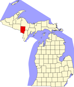
Dickinson County (Michigan)
![The Dickinson County Courthouse in Iron Mountain, listed on NRHP No. 80001852 [1]](https://upload.wikimedia.org/wikipedia/commons/thumb/6/68/2009-0619-IronMountain-Courthouse.jpg/298px-2009-0619-IronMountain-Courthouse.jpg) The Dickinson County Courthouse at Iron Mountain, listed on NRHP No. 80001852 |
|
| administration | |
|---|---|
| US state : | Michigan |
| Administrative headquarters : | Iron Mountain |
| Address of the administrative headquarters: |
705 Stephenson PO Box 609 Iron Mountain, MI 49801 |
| Foundation : | 1896 |
| Demographics | |
| Residents : | 26,168 (2010) |
| Population density : | 13.2 inhabitants / km 2 |
| geography | |
| Total area : | 2013 km² |
| Water surface : | 28 km² |
| map | |
| Website : www.dickinsoncountymi.gov | |
The Dickinson County is a county in the US -amerikanischen State Michigan . In 2010 , the county had 26,168 residents and a population density of 13.2 people per square kilometer. By 2013, the population had decreased to 26,098. The county seat is in Iron Mountain .
geography
The county is located in the west-central part of the Upper Peninsula of Michigan on the Menominee River , which forms the border with Wisconsin until its confluence with Lake Michigan .
Dickinson County covers an area of 201.6 square kilometers, of which 40.5 square kilometers are water.
The following neighboring counties border Dickinson County:
| Marquette County | ||
| Iron County |

|
|
|
Florence County ( Wisconsin ) |
Marinette County, Wisconsin |
Menominee County |
history
Dickinson County is the youngest county in Michigan and was formed in 1896 from parts of the pre-existing Marquette , Menominee and Iron Counties. It was named by President Grover Cleveland after Donald M. Dickinson , an American lawyer and politician.
economy
The county's importance lay primarily in its large iron ore deposits. For example, the Chapin Mine produced 27 million tons of iron ore from 1880 until its closure in 1934.
Attractions
Dickinson County has a wide variety of recreational opportunities. In addition to numerous campsites, riding trails and hiking trails, many of the rivers can be navigated by kayak and canoe. There are numerous opportunities for fishing, hunting, playing golf and mountain biking on special biking trails. Dickinson County is also a popular winter sports area with the Pine Mountain ski jump, numerous cross-country skiing routes and ice fishing events.
In the Iron Mountain Mine in Vulcan , which has been converted into a museum , the everyday life of an iron ore mine can be followed through guided underground train tours.
| Population development | |||
|---|---|---|---|
| Census | Residents | ± in% | |
| 1900 | 17,890 | - | |
| 1910 | 20,524 | 14.7% | |
| 1920 | 19,456 | -5.2% | |
| 1930 | 29,941 | 53.9% | |
| 1940 | 28,731 | -4% | |
| 1950 | 24,844 | -13.5% | |
| 1960 | 23,917 | -3.7% | |
| 1970 | 23,753 | -0.7% | |
| 1980 | 25,341 | 6.7% | |
| 1990 | 26,831 | 5.9% | |
| 2000 | 27,472 | 2.4% | |
| 2010 | 26,168 | -4.7% | |
| 2013 estimate | 26,098 | -0.3% | |
| 1900–1990 2000 2010–2012 | |||
population
According to the 2010 census , Dickinson County had 26,168 people in 11,322 households. The population density was 13.2 inhabitants per square kilometer. Statistically, 2.28 people lived in each of the 11,322 households.
The racial the population was composed of 97.2 percent white, 0.4 percent African American, 0.6 percent Native American, 0.6 percent Asian and other ethnic groups; 1.2 percent were descended from two or more races. Hispanic or Latino of any race was 1.2 percent of the population.
20.2 percent of the population were under 18 years old, 60.3 percent were between 18 and 64 and 19.5 percent were 65 years or older. 50.3 percent of the population were female.
The median income for a household was 44,272 USD . The per capita income was $ 24,682. 11.0 percent of the population lived below the poverty line.
Dickinson County localities
Other Unincorporated Communities
structure
In addition to the three cities, Dickinson County is divided into seven townships :
| Township | Population (2010) |
FIPS |
|---|---|---|
| Breen Township | 499 | 26-10200 |
| Spread Charter Township | 5853 | 26-10220 |
| Felch Township | 752 | 26-27660 |
| Norway Township | 1489 | 26-59240 |
| Sagola Township | 1106 | 26-70600 |
| Waucedah Township | 804 | 26-84700 |
| West Branch Township | 63 | 26-85520 |
See also
Individual evidence
- ^ Extract from the National Register of Historic Places.Retrieved March 13, 2011
- ↑ GNIS-ID: 1622964. Retrieved on February 22, 2011 (English).
- ↑ a b c U.S. Census Bureau, State & County QuickFacts - Dickinson County, MI ( Memento of the original from July 9, 2011 on WebCite ) Info: The archive link was automatically inserted and has not yet been checked. Please check the original and archive link according to the instructions and then remove this notice. Retrieved May 21, 2014
- ↑ a b National Association of Counties.Retrieved May 21, 2014
- ^ Extract from Census.gov.Retrieved February 18, 2011
- ↑ Missouri Census Data Center - Michigan ( page no longer available , search in web archives ) Info: The link was automatically marked as defective. Please check the link according to the instructions and then remove this notice. Retrieved May 21, 2014
Web links
Coordinates: 46 ° 0 ′ N , 87 ° 52 ′ W

