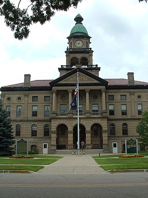
Van Buren County, Michigan
 Van Buren County Courthouse |
|
| administration | |
|---|---|
| US state : | Michigan |
| Administrative headquarters : | Paw Paw |
| Foundation : | 1829 |
| Demographics | |
| Residents : | 76,263 (2000) |
| Population density : | 48.2 inhabitants / km 2 |
| geography | |
| Total area : | 2824 km² |
| Water surface : | 1241 km² |
| map | |
| Website : www.vbco.org | |
Van Buren County is a county in the state of Michigan in the United States . The county seat is the city of Paw Paw .
geography
Van Buren County is located in southwest Michigan, through the county runs the highway and the railway line from Chicago to Detroit . At South Haven, the county also has access to Lake Michigan . It is bordered to the southwest by Berrien County, to the south by Cass County, to the southeast by St. Joseph County, to the east by Kalamazoo County, and to the north by Allegan County.
history
The county was named after US President Martin Van Buren before he became president. At that time he was serving as Secretary of State under Andrew Jackson . Other Jackson cabinet members were named patrons of counties in Michigan, which are therefore also called "Cabinet Counties".
Seven structures and sites in the county are listed on the National Register of Historic Places (as of January 28, 2018).
| growth of population | |||
|---|---|---|---|
| Census | Residents | ± in% | |
| 1830 | 5 | - | |
| 1840 | 1910 | 38,100% | |
| 1850 | 5800 | 203.7% | |
| 1860 | 15,224 | 162.5% | |
| 1870 | 28,829 | 89.4% | |
| 1880 | 30,807 | 6.9% | |
| 1890 | 30,541 | -0.9% | |
| 1900 | 33,274 | 8.9% | |
| 1910 | 33.185 | -0.3% | |
| 1920 | 30,715 | -7.4% | |
| 1930 | 32,637 | 6.3% | |
| 1940 | 35.111 | 7.6% | |
| 1950 | 39,184 | 11.6% | |
| 1960 | 48,395 | 23.5% | |
| 1970 | 56.173 | 16.1% | |
| 1980 | 66,814 | 18.9% | |
| 1990 | 70.060 | 4.9% | |
| 2000 | 76.263 | 8.9% | |
| 2010 | 76,258 | -0% | |
| Before 1900
1900–1990 2000 + 2010 |
|||
Natural space
Van Buren County is largely dominated by agriculture; on the other hand, the urbanization around the city of Kalamazoo can be seen on the border with Kalamazoo County , which borders on the east .
Almost half of the county's area is covered by water. In addition to the two major rivers in the area, the Paw Paw River and the Black River, these are a number of lakes, of which Paw Paw Lake is the most important. The county is also rich in nature reserves and nature reserves, which are mostly visited by day trippers from nearby Chicago. Mention should be made of the Dunes Parkway, a 340,000 m² dune area near the city of Covert, the Jeptha Lake near the city of Columbia, the Kal-Haven Trail, a hiking trail on the disused railway line from Kalamazoo to South Haven, the Van Buren Trail State Park, the Keeler State Game Area in the city of Keeler, the Ross Preserve, a 5.9 km² large protected area on the coast near Covert, and the Van Buren State Park.
Residents
Of the 76,263 inhabitants, 87.9 percent are white, 5.3 percent African-American, 0.9 percent Native American descent, 7.4 percent are Latinos or Hispanics. The average annual per capita income is 17.878 US dollars . 11.1 percent of the population live below the poverty line.
Communities
The county's largest communities are:
- Hartford (2476 inhabitants)
- Paw Paw (3363 inhabitants)
- South Haven (5021 inhabitants)
Web links
Individual evidence
- ↑ GNIS-ID: 1623020. Retrieved on February 22, 2011 (English).
- ↑ Search mask database in the National Register Information System. National Park Service , accessed January 28, 2018.
- ↑ US Census Bureau - Census of Population and Housing . Retrieved March 15, 2011
- ↑ Extract from Census.gov . Retrieved February 18, 2011
- ↑ Extract from census.gov (2000 + 2010). Accessed April 4, 2012
- ^ Van Buren County, Michigan , 2000 census data sheet at factfinder.census.gov .
Coordinates: 42 ° 16 ′ N , 86 ° 19 ′ W

