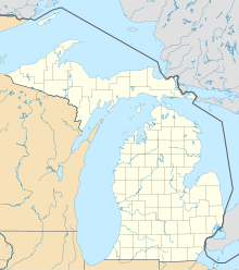
Saginaw Bay
Coordinates: 43 ° 55 ′ N , 83 ° 35 ′ W
The Saginaw Bay (Saginaw Bay) is a bay of Lake Huron , which the county Arenac County , Bay County , Tuscola County and Huron County in the US state of Michigan borders. In the bay are the islands of Maisou Island and Heisterman Island . The Saginaw River flows into the bay . The bay and river are named after the Sauk , an Indian tribe who lived in the area in the early seventeenth century.
background
Saginaw Bay is a large contiguous freshwater catchment area in Michigan. The Saginaw Bay Watershed Initiative Network (WIN) was founded in order to secure and improve the quality of life on site by creating regional facilities with so-called "on-the-ground projects". Innovative projects in the region are promoted through grants. The projects combine economic, ecological and communal objectives. In them communities, conservationists, foundations and companies work together to implement these goals. At nearly 8,700 square miles, the area is home to around 1.4 million people as well as a habitat for many animal species. For example, these projects were supported with three grants from 1992 to 1994 of $ 600,000 each from the Environmental Protection Agency (EPA) as part of the Great Lakes Basin Program, which funded 49 projects dealing with soil erosion and Sedimentation in Saginaw Bay.
Lake Huron's Saginaw Bay is made up of several large coastal wetlands. Important wet meadows extend between Point AuGres and Nayanquing Point, from Tobico Beach at the mouth of the Saginaw River to Fish Point and on the Maisou Island Complex from Sebewaing to Wildfowl Bays. The situation of the wetlands in the bay lost large areas in the period from 1859 to 1973 due to drainage for agricultural use or settlement. In the region between Fish Point and Sand Point alone, around 4,798 acres were drained for conversion into arable land. At the same time, the swamping of the water surface increased due to the conversion from rushes and wild rice to cattails as the predominant plant species.
Geography and history
The Saginaw County is located in central Michigan in a region known as " Tri-Cities area " ( Saginaw , Midland and Bay City is referred to). It is located south of Bay County and does not directly border Saginaw Bay, but is traversed by the Saginaw River. In addition to Bay County, Arenac County, Huron County and Tuscola County are the direct residents with access to the Bay. This is part of the Huron Lake.
The earliest evidence of settlement in the Saginaw Valley comes from nomadic paleo-Indians who lived here around 12,000 years ago and hunted mammoths and other large game here . The first permanent settlements arose around 3000 BC. These early inhabitants included the Hopewell culture who lived along the Saginaw River around 500 BC. Other tribes were Chippewa, Ojibwa , Odawa or Potawatomi . The name of the area and the river is derived from a term from the language of the Ojibwa Indians, who lived here at the time of the first European explorers and missionaries around 1650. “O-Sag-e-non” or “Sag-in-a-we” roughly means “to flow” and was probably related to the mouth of the river in Saginaw Bay. In the mid-1800s, the wood of the forests gave rise to an upswing in the Saginaw, Bay, and Midland regions, which brought them prosperity and fame. There were more than 100 active sawmills during this boom. When the timber industry began to lose momentum, new sources of income were sought and the focus was initially on agriculture and coal mining. Various industrial products were added later, so that finally the automotive industry also settled here.
literature
- L. J Danek, J. H Saylor, Environmental Research Laboratories (US), Great Lakes Environmental Research Laboratory: Saginaw Bay water circulation . US Dept. of Commerce, National Oceanic and Atmospheric Administration, Environmental Research Laboratories, Boulder, Colo. 1975, OCLC 2197259 .
- Survey of chemical factors in Saginaw Bay (Lake Huron) . US Environmental Protection Agency, Office of Research and Development, Duluth January 1, 1977, OCLC 3601851 .
- William A. Stout: Saginaw Bay waterfowl hunting and decoy carvers . 1st edition. Fanfair Enterprises, Bloomington Hills, MI 2006, ISBN 0-9787564-0-1 .
Web links
- Website on saginawbay.com
- Saginaw River and Bay on epa.gov
Individual evidence
- ↑ Saginaw Bay WIN. In: saginawbaywin.org. Retrieved August 28, 2015 .
- ^ Great Lakes Basin Program Projects. (No longer available online.) Projects.glc.org, formerly in the original ; accessed on August 28, 2015 . ( Page no longer available , search in web archives ) Info: The link was automatically marked as defective. Please check the link according to the instructions and then remove this notice.
- ↑ Maisou Island Complex: Evaluation of marsh losses Prepared for Wildlife Division, Michigan Department of Natural Resources. In: gpo.gov. Retrieved August 28, 2015 .
- ^ A b Saginaw Facts & History. (No longer available online.) Public Libraries of Saginaw, archived from the original on May 14, 2015 ; accessed on August 28, 2015 . Info: The archive link was inserted automatically and has not yet been checked. Please check the original and archive link according to the instructions and then remove this notice.
- ^ A b History - Saginaw County Chamber of Commerce. (No longer available online.) In: saginawchamber.org. Archived from the original on February 26, 2015 ; accessed on August 28, 2015 . Info: The archive link was inserted automatically and has not yet been checked. Please check the original and archive link according to the instructions and then remove this notice.
