Ada County
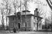
 Ada County Courthouse |
|
| administration | |
|---|---|
| US state : | Idaho |
| Administrative headquarters : | Boise |
| Address of the administrative headquarters: |
County Courthouse 200 West Front Street Boise, ID 83702-7300 |
| Foundation : | December 22, 1864 |
| Made up from: | Boise County |
| Area code : | 001 208 |
| Demographics | |
| Residents : | 392,365 (2010) |
| Population density : | 143.6 inhabitants / km 2 |
| geography | |
| Total area : | 2746 km² |
| Water surface : | 14 km² |
| map | |
Ada County is a county in the state of Idaho in the United States . The county seat is Boise , which is also the capital of Idaho. The district was named after Ada Riggs, who was the first white child born in the area.
geography
The county is located in southwest Idaho, about 45 km to the west from Oregon and has an area of 2,746 square kilometers, of which 14 square kilometers are water. It is bordered clockwise by the following counties: Boise County , Elmore County , Owyhee County , Canyon County, and Gem Counties . It is almost entirely within the Snake River Plain .
history
| growth of population | |||
|---|---|---|---|
| Census | Residents | ± in% | |
| 1870 | 2675 | - | |
| 1880 | 4674 | 74.7% | |
| 1890 | 8638 | 84.8% | |
| 1900 | 11,559 | 33.8% | |
| 1910 | 29,088 | 151.6% | |
| 1920 | 35,213 | 21.1% | |
| 1930 | 37,925 | 7.7% | |
| 1940 | 50,401 | 32.9% | |
| 1950 | 70,649 | 40.2% | |
| 1960 | 93,460 | 32.3% | |
| 1970 | 112.230 | 20.1% | |
| 1980 | 173.036 | 54.2% | |
| 1990 | 205,775 | 18.9% | |
| 2000 | 300.904 | 46.2% | |
| 2010 | 392.365 | 30.4% | |
| Before 1900
1900–1990 2000 + 2010 
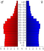
Age pyramid of Ada County (as of 2000)
|
|||
Ada County was formed on December 22, 1864 from parts of Boise County. It is named after Ada Riggs , the first pioneer child in the area and daughter of HC Riggs , one of the co-founders of Boise.
In 1811 the first British trappers came to the area and in 1834 Fort Boise , near Parma, was built. It also served as a trading post and stop on the Oregon Trail . After the old fort was abandoned in 1954, a fort of the same name was established on the site of the current city of Boise in 1963.
The summer of 1862 saw the first gold discoveries that made the county known. From 1864, the Ben Holladay's Stage Company provided the first regular passenger transport connections to Walla Walla ( Washington ) and Salt Lake City ( Utah ) by means of horse-drawn carriages .
Beginning in 1869, the Council Bluffs , Iowa , to Sacramento , California railroad ran through this area, giving settlers the opportunity to sell their produce further afield. In 1882 the Oregon Short Line Railroad was added and the first industry developed. From 1887 there was also a connection to the Idaho Central Railroad .
In 1890, the first hot spring baths with an indoor pool and recreational areas were opened thanks to the existing hot springs , and the county was the first county in the United States to be supplied with hot water using geothermal energy .
From 1900 the wood industry gained in importance. The first sawmill was built in 1905 and the first power plant in 1906, driving electrification in the county. The central water supply was also started.
In the Federal Highway Act of 1921 , the construction of two highways was decided and then started. In 1926, US Highway 30 , also known as the Old Oregon Trail Highway , was opened and from 1928 so-called Auto Stage Lines (bus lines) operated as an alternative to the railroad and the approximately 100 km long rail-bound trolley line in the county, which had been built 20 years earlier.
On April 6, 1926, the first regular airmail service was started with a double-decker . This was also the actual start of United Airlines , which was founded in December 1929.
In the wake of World War II , the Whitney Field military base , later renamed Gowen Field , was established in the county . It specialized in the training of bomber pilots and brought the region a rapid economic upswing combined with an increase in the population.
Ada County has a National Historic Landmark , the Assay Office . 154 other sites and structures are on the National Register of Historic Places .
Demographic data
According to the 2000 census , Ada County had 300,904 people in 113,408 households and 77,344 families. The population density was 110 people per square kilometer. The racial the population was composed of 92.86 percent white, 0.65 percent African American, 0.69 percent Native American, 1.74 percent Asian, 0.15 percent from the Pacific island area and 1.67 percent from other ethnic groups Groups; 2.24 percent were descended from two or more races. 4.48 percent of the population are Spanish or Latin Americans.
Of the 113,408 households, 36.2 percent had children under the age of 18 living with them. 55.1 percent of them were married couples living together. 9.4 percent were single mothers and 31.8 percent were non-families. 23.8 percent were single households and 6.7 percent had people 65 years of age or older. The average household size was 2.59 and the average family size was 3.11.
27.3 percent of the population were under 18 years old, 10.3 percent between 18 and 24 years, 32.5 percent between 25 and 44 years, 20.8 percent between 45 and 64 years. 9.1 percent were 65 years of age or older. The median age was 33 years. For every 100 females there were 100.6 males. For every 100 women aged 18 and over there were 98.9 men.
The median household income was 46,140 USD , and the median income for a family 54,416 USD. Males had a median income of $ 37,867 versus $ 26,453 for females. The per capita income was $ 22,519. 5.4 percent of families and 7.7 percent of the population lived below the poverty line.
Places in Ada County
Census-designated places (CDP)
See also
Web links
Individual evidence
- ↑ GNIS-ID: 395066. Retrieved on February 22, 2011 (English).
- ↑ US Census Bureau - Census of Population and Housing . Retrieved March 15, 2011
- ↑ Extract from Census.gov . Retrieved February 14, 2011
- ↑ Extract from census.gov (2000 + 2010) ( Memento of July 3, 2011 in the Internet Archive ) Retrieved on April 2, 2012
- ↑ Search mask database in the National Register Information System. National Park Service , accessed August 25, 2017.
- ↑ Page no longer available , search in web archives: Ada County, Idaho , data sheet with the results of the census in 2000 at factfinder.census.gov .
Coordinates: 43 ° 27 ′ N , 116 ° 14 ′ W


