Banks Lake (Washington)
| Banks Lake | |||
|---|---|---|---|
|
|||
|
|
|||
| Coordinates | 47 ° 37 '12 " N , 119 ° 18' 27" W | ||
| Data on the structure | |||
| Data on the reservoir | |||
| Altitude (at congestion destination ) | 1,571 ft (479 m) | ||
| Water surface | 26,886 acres (109 km²) | ||
| Reservoir length | 31 mi (49.9 km) | ||
| Maximum depth | 177 ft (53.9 m) (mean depth 46 ft (14 m)) | ||
| Total storage space : | 1 560 000 000 m³ | ||
The Banks Lake is a 27 mi (43.5 km) long artificial lake in the central part of the US state of Washington . Its circumference is 135 mi (about 220 km).
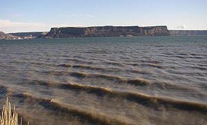
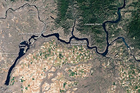
As part of the Columbia Basin Project , Banks Lake covers the northern part of the Grand Coulee , a formerly dry river terrace (English "coulee") near the Columbia River , which was left by the Missoula Floods during the Pleistocene . The Grand Coulee Dam , built by the United States Bureau of Reclamation , created Franklin D. Roosevelt Lake on the Columbia River . Lake Roosevelt's surface is several hundred feet above the pristine Columbia River, making it easy to pump water over 280 ft (85.3 m) above the river's canyon onto the adjacent Grand Coulee. Two low earth dams, the Dry Falls Dam and the North Dam , hold the water in the Grand Coulee, creating a reservoir called Banks Lake. It is named after Frank A. Banks, the site manager at Grand Coulee Dam.
At the north end of Banks Lake are the town of Grand Coulee and the small town of Electric City . The Steamboat Rock State Park is located in the north central part of the lake. The small town of Coulee City is at the southern end of the lake. From there, the water stored in Banks Lake will be distributed over a large area for irrigation as part of the Columbia Basin Project.
Satellite image
In this picture taken in summer, land areas appear in shades of beige, brown and green. In contrast to the jagged, irregular contours of the local peaks, cultivated land appears as a network of rectangles, some of them green, others beige or yellow-brown. Light green dots represent fields with pivot irrigation systems . The greatest concentration of agricultural areas is to be found south of the dam. To the north of the reservoir, hills covered with vegetation dominate. Flatter uncultivated terrain appears gray-beige, possibly due to the sparse vegetation, especially in the northwest.
Web links
swell
- Kirk, Ruth and Carmela Alexander (1995) Exploring Washington's Past: A Road Guide to History, Revised Edition , University of Washington Press, Seattle (1990, revised edition 1995). ISBN 0-295-97443-5
- Columbia Basin Irrigation Project (English)
Individual evidence
- ↑ Grand Coulee Dam This article contains text from the NASA website that is published under a public domain license.


