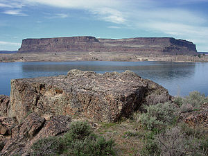
Steamboat Rock State Park
|
Steamboat Rock State Park
|
||
| location | Grant County , Washington , USA | |
| surface | 14.25 km² | |
| Geographical location | 47 ° 52 ' N , 119 ° 8' W | |
|
|
||
| Setup date | 1972 | |
| administration | Washington State Parks and Recreation Commission | |
The Steamboat Rock State Park is a 3,522 acres (14 km²) great State Park in the State of Washington , near the north end of Banks Lake in Grand Coulee . The park's name comes from the landschaftsdominierenden object, the Steamboat Rock ( German steamship Rock , a) Basalt - Härtling , the 800 ft rises (about 240 m) above the lake that surrounds him almost completely. The Härtlings Plateau covers more than 600 acres (2 km²) and was used by nomadic indigenous tribes and the early white settlers. During the last ice age , the monolith stood as an island in the new bed of the Columbia River , where it was divided by ice dams. When the dams broke and huge floods created the Channeled Scablands , the Columbia returned to its original course, leaving Steamboat Rock as a prominent feature in the arid Grand Coulee.
tourism
The park covers 50,000 ft (15,240 m) shoreline and is open to day and camping tourists year-round. There are trails for walking, cycling and horse riding; water sports activities are also possible: boating, swimming, water-skiing and fishing. Winter sports options include cross-country skiing, ice fishing, and ice climbing.
Individual evidence
- ^ A b c Cassandra Tate: Steamboat Rock State Park . In: The Online Encyclopedia of Washington State History . HistoryLink. October 11, 2005. Retrieved November 24, 2007.
- ↑ a b Steamboat Rock State Park . Washington State Parks and Recreation Commission. Retrieved August 27, 2018.
Web links
- Steamboat Rock State Park ( English ) In: Geographic Names Information System . United States Geological Survey .
- Steamboat Rock State Park - Washington State Parks and Recreation Commission website
- Steamboat Rock State Park map - Washington State Parks and Recreation Commission website

