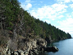
Larrabee State Park
|
Larrabee State Park
|
||
| location | Whatcom County in Washington (USA) | |
| surface | 1086 ha | |
| Geographical location | 48 ° 39 ' N , 122 ° 29' W | |
|
|
||
| Setup date | 1915 | |
| administration | Washington State Parks and Recreation Commission | |
The Larrabee State Park is located in Whatcom County in the western US state of Washington . It is about 7 miles south of Bellingham on State Highway 11 (Chuckanut Drive).
The park is named after its founder Charles Xavier Larrabee , who donated twenty acres (about eight hectares) of land to the state in 1915. At that time still called Chuckanut State Park , it was one of the first two state parks in Washington with a building from the pioneering days (" John R. Jackson House State Historic Site ") .
Today the state park covers an area of 2,683 acres and nearly 2.5 km of coastline on Samish Bay . The park is open all year round, but with limited recreational opportunities between October 16 and March 31. There are 75 campsites available, including 26 so-called "full hook-ups". H. with power supply, water and sewage connection. The park has more than 38 km of hiking trails in the Chuckanut Mountains , some of which lead to viewpoints over the San Juan Islands and Mount Baker and to Fragrance Lake and Lost Lake, two mountain lakes. Recreational opportunities in the park include snorkeling, fishing (including clams and crabs), and hiking.

