
San Juan Islands
| San Juan Islands | ||
|---|---|---|
 |
||
| Waters | Salish Sea | |
| Geographical location | 48 ° 34 ′ N , 122 ° 56 ′ W | |
|
||
| Number of islands | 172 | |
| Main island | San Juan Island | |
| Residents | 16,000 | |
 |
||

The San Juan Islands are a group of islands in the northwest of the US state Washington . Depending on the definition of "island" (as opposed to rocks protruding from the water) one speaks of 172 or even several hundred islands and islets that are assigned to the San Juans. 172 is the number of islands that are large enough to be labeled with their own name. Occasionally one also finds the indication of 176 islands with their own names. About 16,000 people live on the San Juan Islands.
The islands are located east of the Canadian island of Vancouver Island or the Haro Strait and the Boundary Pass and separate the Juan de Fuca Strait in the south from the Strait of Georgia in the north. The eastern border is Rosario Street . The three largest islands are San Juan Island , Orcas Island, and Lopez Island .
The San Juan Islands make up the San Juan County . The San Juan Islands National Monument with 75 areas is located on the islands . Furthermore, the state parks Moran State Park , Blind Island State Park, Clark Island State Park, Doe Island State Park, James Island State Park, Jones Island State Park, Lime Kiln Point State Park, Matia Island State Park, Obstruction Pass State Park, Patos Island State Park, Posey Island State Park, Saddlebag Island State Park, Skull Island State Park, Spencer Spit State Park, Stuart Island State Park, Sucia Island State Park, Turn Island State Park in the islands. Most of the time, these state parks are just campsites with a little bit of surroundings. Only the Moran State Park with an area of 2,258 hectares is a kind of protected area comparable to a nature park .
history
Before the arrival of the first Europeans, the islands belonged to the settlement area of the coastal Salish , the Nooksack , the Northern Straits Salish (to which the Lummi belong) and Klallam are counted. The coastal Salish migrated in the wake of the seasons within their respective areas, so inhabiting their villages only intermittently. The Lummi settled in this sense on the San Juan Islands and laid out reef nets there on Orcas Island, San Juan Island, at Point Roberts and at Sandy Point. Around 1780 their number is estimated at around 1,000 people. However, the first contact with Europeans led to smallpox epidemics among them from the late 1770s and in the following decades they migrated from British Columbia to the neighboring mainland, fleeing from the smallpox and looting tribes .
The first European to discover San Juan Island was an officer in 1791 under the command of the Spanish explorer Francisco de Eliza named Gonzalo López de Haro. The Haro Strait , which separates San Juan Island from Vancouver Island, is named after him. De Eliza gave the island and archipelago their name, Isla y Archipelago de San Juan . Since the expedition sailed under the authority of the viceroy of Mexico, Juan Vicente de Güemes Padilla Horcasitas y Aguayo , De Eliza named various places after him, in addition to San Juan Island also Orcas Island (short for Horcasitas).
A year earlier, Spaniards had already sighted the islands during a voyage under the command of Manuel Quimper , but without realizing that they were islands.
The two Spanish expeditions were followed by British and American expeditions. George Vancouver Expedition of 1792 and 1841 the reconnaissance trip by Charles Wilkes led to a number of Spanish names of the islands have been replaced by English. Vancouver still had some information from Spanish sources and mostly took over the Spanish names. Wilkes, on the other hand, may not have known the Spanish names and in many cases he gave new names to islands and waterways that had already been named by the Spaniards or by Vancouver. He often used it to honor members of his crew or American heroes of the war of 1812 against the British. For example, he named the San Juan Islands the Navy Archipelago and several islands were named by American naval officers.

In order to resolve the resulting confusion of names on different maps, the British Admiralty started a project in 1847 under the direction of Henry Kellett to clarify the name issues in the region. Since the San Juans were claimed by the British at that time, the patriotic American names that Wilkes had given disappeared in favor of the original Spanish names or names given by Vancouver, with few exceptions.
The text of the Oregon Compromise of 1846, by which the 49th parallel was established as the border between US and British-Canadian territory, omitted the clarification of the affiliation of the San Juan Islands. This lack of clarity led to the so-called pig conflict in 1859 over the course of the border between the USA and Great Britain in the area of the archipelago. A (British) pig shot by a US farmer was the only victim of the conflict. The border dispute was finally resolved only in 1872 after the German Emperor Wilhelm I had been asked to mediate.
The islands are namesake for the Indian tribe of the Mitchell Bay Band of San Juan Islands .
The San Juan Islands in Literature
The novel Island of Whispering Voices by Laurie R. King is set on the fictional San Juan Island "Folly".
The novels "Amber Beach" (Eng. Amber Fire) and "Jade Island" (Eng. Jade Hearts) by Elizabeth Lowell are set in the San Juan Islands.
The novel "What I Didn't Say" by Keary Taylor is set on Orcas Island.
Incomplete list of the San Juan Islands

- Aleegria Island
- Allan Island
- Anderson Island
- Armitage Island
- Barnes Island
- Barren Island
- Battleship Island
- Bell Island
- Blakely Island
- Blind Island
- Boulder Island
- Brown Island
- Buck Island
- Burrows Island
- Cactus Islands
- Canoe Island
- Castle Island
- Cemetery Island
- Center Island
- Clark Island
- Cliff Island
- Colville Island
- Coon Island
- Crab Island
- Crane Island
- Cypress Island
- Deadman Island
- Decatur Island
- Dinner Island
- Doe Island
- Double Island
- Eliza Island
- Ewing Island
- Fawn Island
- Fidalgo Island
- Flattop Island
- Flower Island
- Fortress Island
- Freeman Island
- Frost Island
- Goose Island
- Gossip Island
- Guemes Island
- Guss Iceland
- Hall Island
- Has Iceland
- Henry Island
- Iceberg Island
- James Island
- Johns Island
- Jones Island
- Justice Island
- Little Island
- Little Patos Island
- Little Sister Island
- Lone Tree Island
- Lopez Island
- Low Island
- Lummi Island
- Matia Island
- Mcconnell Island
- Minor Island
- Nob Island
- North Finger Island
- Obstruction Island
- O'Neal Island
- Orcas Island
- Patos Island
- Pearl Island
- Picnic Island
- Pointer Island
- Pole Island
- Portage Island
- Posey Island
- Puffin Island
- Ram Island
- Reef Island
- Rim Island
- Ripple Island
- Rum Island
- Samish Island
- San Juan Island
- Satellite Island
- Sentinel Island
- Shaw Island
- Sheep Island
- Sinclair Island
- Skull Island
- Small Island
- Smith Island
- South Finger Island
- Spieden Iceland
- Strawberry Island
- Stuart Island
- Sucia Island
- Swirl Island
- Towhead Island
- Trump Island
- Turn Island
- Vendovi Island
- Victim Island
- Waldron Island
- Wasp Islands
- Willow Island
- Yellow Island
Photo gallery

Iceberg Point, Lopez Island
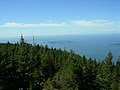
View from Mt. Constitution (Orcas Island)
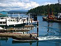
Friday Harbor


literature
- Amanda K. Taylor, Julie K. Stein, Stephanie AE Jolivette: Big Sites, Small Sites, and Coastal Settlement Patterns in the San Juan Islands, Washington, USA , in: The Journal of Island and Coastal Archeology 6.2 (2011) 287 -313.
Web links
swell
- ↑ The San Juan Islands Afoot & Afloat , Marge Mueller, Ted Mueller, Mountaineers Books 2004
- ↑ http://www.visitsanjuans.com/index.cfm?action=isle
- ↑ San Juan Islands ( English ) In: Geographic Names Information System . United States Geological Survey . Retrieved January 31, 2011.
- ↑ Archived copy ( memento of the original dated September 23, 2006 in the Internet Archive ) Info: The archive link was inserted automatically and has not yet been checked. Please check the original and archive link according to the instructions and then remove this notice.
- ↑ Phillips, James W. (1971). Washington State Place Names. University of Washington Press. ISBN 0-295-95158-3