Boundary Pass
| Boundary Pass | ||
|---|---|---|
| Boundary Pass | ||
| Connects waters | Juan de Fuca street | |
| with water | Strait of Georgia | |
| Separates land mass | Gulf Islands | |
| of land mass | San Juan Islands | |
| Data | ||
| Geographical location | 48 ° 44 ′ N , 123 ° 9 ′ W | |
|
|
||
| length | 23 km | |
| Smallest width | 10 km | |
| Greatest depth | 300 m | |
| Boundary Pass between the southern Gulf Islands and the San Juan Islands | ||
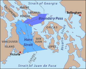
The Boundary Pass is only about 23 kilometers long and about 10 kilometers wide waterway of the Pacific Ocean in the southwest part of British Columbia , which separates the southern Gulf Islands and the San Juan Islands . The course of the road here forms the border between Canada and the United States .
At the same time, this shipping route is one of the busiest on the North American west coast as it is the main access route to the port of Vancouver and the Strait of Georgia .
definition
The USGS defines the course or the limits of the boundary pass as described below.
The northern border is formed by a line from East Point on Saturna Island to Alden Point on Patos Island . Furthermore, the southwestern border results from a line from Point Fairfax on Moresby Island to Turn Point on Stuart Island .
In the northwest, the Boundary Pass is limited by various points on the islands of Saturna Island, Pender Island and Moresby Island. To the southeast it is limited by points on Patos Island as well as Waldron Island and Stuart Island.
According to this definition, the Boundary Pass merges directly into the Strait of Georgia at its northern end. At the southern end, it is not directly connected to Juan de Fuca Street via Haro Street .
In various other definitions, the boundary pass is included in the description of the Haro Strait.
history
In 1846, with the so-called Oregon Treaty, the border between the United States and Great Britain was established along the 49th parallel, in the middle of the channel that separates the continent from Vancouver Island , and in the middle of the Juan de Fuca Strait to the Pacific Ocean set. Due to the many islands located there, there are two waterways that lead through the middle of the channel, on the one hand the Haro Strait , with its continuation in the Boundary Pass, west of the San Juan Islands and on the other hand the Rosario Strait along the east side of the archipelago. In 1859 a "war" broke out between Great Britain and the United States of America over the exact course of the border, the Pig Conflict .
climate
The climate and the water temperatures in the Boundary Pass are basically the same as those of the surrounding area of the Strait of Georgia, the Strait of Juan de Fuca and the Strait of Rosario. According to the Köppen climate classification , the climate is Mediterranean (Csb).
See also
literature
- Sheila Harrington, Judi Stevenson (Eds.): Islands in the Salish Sea: A Community Atlas, Surrey 2005, 2nd ed. 2007.
Web links
- Boundary Pass . In: BC Geographical Names (English)


