Fidalgo Island
| Fidalgo Island | ||
|---|---|---|
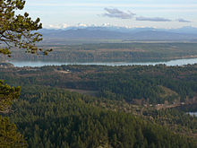
| The forested west flank of Fidalgo Island overlooks Puget Sound | ||
| Waters | Puget Sound ( Pacific Ocean ) | |
| Archipelago | San Juan Islands | |
| Geographical location | 48 ° 28 ′ N , 122 ° 38 ′ W | |
|
|
||
| surface | 106.7 km² | |
| Highest elevation | Mount Erie 388 m |
|
| Residents | 20,700 (2000) 194 inhabitants / km² |
|
| main place | Anacortes | |
Fidalgo Island is an inhabited, forested, and hilly island in the US state of Washington that is part of the San Juan Islands . It is 106.7 km² in size. Fidalgo Island is located in Skagit County , making it one of the state's westernmost archipelago . The largest place on the island is Anacortes with 14,557 inhabitants, a total of 20,700 people live on Fidalgo Island. (Status: US Census 2000)
To the east, the island is separated from the mainland by the Swinomish Channel . To the south, the Deception Pass Bridge , which spans the Deception Pass , connects the island with Whidbey Island .
Fidalgo Island was originally settled by the Samish and Swinomish indigenous people .
The island is named after the Spanish navigator, cartographer and explorer Salvador Fidalgo , who explored the area in 1790 with Francisco de Eliza's fleet . Charles Wilkes then discovered that this was not the mainland, but an island, which he named Perry Island . Oliver Hazard Perry was the American leader in the Battle of Lake Erie during the British-American War of 1812 . When Henry Kellett reorganized the British Admiralty's charts in 1847, he deleted the name Perry and renamed Fidalgo . The highest point on the island retained the Wilkes name, Mount Erie .
The biggest surge in settlement came in the 1850s with the Fraser River Gold Rush , and in 1890 when it was speculated that the terminus of the Northern Pacific Railroad might be built here. Today fishing companies and logging companies are located here.
Seattle to the south can be reached by land in two hours. There are ferry connections to Victoria ( Canada ) and to various locations in the San Juan Islands .
Individual evidence
- ↑ James W. Phillips: Washington State Place Names . University of Washington Press, 1971, ISBN 0-295-95158-3 .
swell
- Early History of Fidalgo Island . English.


