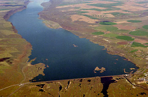
Dry Falls Dam
| Dry Falls Dam ( Banks Lake ) |
|||||||
|---|---|---|---|---|---|---|---|
|
|||||||
|
|
|||||||
| Coordinates | 47 ° 37 '12 " N , 119 ° 18' 27" W | ||||||
| Data on the structure | |||||||
| Construction time: | 1946-1949 | ||||||
| Height of the barrier structure : | 123 ft (37 m) | ||||||
| Crown length: | 9,800 ft (2,987 m) | ||||||
| Base width: | 480 ft (146 m) | ||||||
| Operator: | United States Bureau of Reclamation | ||||||
| Data on the reservoir | |||||||
| Water surface | 109 km² | ||||||
| Total storage space : | 1 573 000 000 m³ | ||||||
| Catchment area | 721 km² | ||||||
The Dry Falls Dam (also South Coulee Dam or South Dam ) is an earth-filled, rock-built dam in Grant County , Washington state . It was built near Coulee City as part of the United States Bureau of Reclamation's Columbia Basin Project . The water of the Columbia River dammed by the Grand Coulee Dam is pumped into the Grand Coulee , a formerly dry canyon , with the help of the Feeder Canal . The north end of the Grand Coulee is sealed by the North Dam ; the Dry Falls Dam extends in the middle of the Coulee (German here "river terrace"). This makes it possible to use the water pumped by the Columbia River to fill the upper Grand Coulee and to fill a large compensation basin , Banks Lake . The water from the reservoir is fed into the main canal of the irrigation project, which runs from the Dry Falls Dam to another reservoir, Billy Clapp Lake, which is formed by the Pinto Dam .
construction
Both the North Dam and the Dry Falls Dam are earth-filled structures built out of rock. They were built to create Banks Lake, a 27 mi (43 km) long equilibrium pool with a storage capacity of approximately 1.5 km³ for irrigation purposes. The backflow into the Columbia River provides the opportunity for electrical power generation. The Feeder Canal to Banks Lake has a capacity of 736 cubic meters per second, The Dry Falls Dam and the outlet to the Main Canal are located near Coulee City . The outlet ( Main Canal Headworks ) is not part of the Dry Falls Dam; it was expanded by six pump / generator units. The Main Canal was expanded from 50 ft (15 m) to 80 ft (24 m).
history
Construction of the Dry Falls Dam began in 1946 under the name South Coulee Dam. The company Roy L. Blair and Company and James Crick and Sons won the tender with a construction cost of 2,771,887 USD. Work started in mid-July. The contract included the construction of the dam across the Grand Coulee, the inlet canal, the outlet and standard structure and the initial stretch of the drainage canal. An outcropping channel for the entire length of the dam was driven through the rock . A continuous concrete wall was erected in the center of the trench with feet every 3 ft (0.9 m). The wall prevents seepage under the dam and is 1.5 ... 3 m high. Construction of the drainage channel began in March 1948 and was completed a year later. The dam was designed as an earth dam with an impermeable core, a semi-permeable layer on each side of the core and a stone-filled layer at the end. The semi-permeable layer was constructed in compacted one-foot layers (0.3 m). The final layer was carried out in three-foot layers (approx. One meter) without compaction.
See also
Individual evidence
- ↑ United States Bureau of Reclamation: Dry Falls Dam: General . May 17, 2012. Retrieved January 23, 2015.
- ^ A b c The Story of the Columbia Basin Project . United States Government Printing Office, Washington DC 1964, p. 59 (Retrieved January 23, 2015).
- ↑ United States Bureau of Reclamation: Dry Falls Dam: Hydraulics and Hydrology . May 17, 2012. Retrieved January 23, 2015.
- ↑ Columbia Basin Project ( Memento of the original from December 6, 2008 in the Internet Archive ) Info: The archive link was automatically inserted and has not yet been checked. Please check the original and archive link according to the instructions and then remove this notice. , Bureau of Reclamation
- ↑ a b c d e https://www.usbr.gov/projects/facilities.php?region=Pacific Northwest
Web links
- Dry Falls Dam - Bureau of Reclamation website

