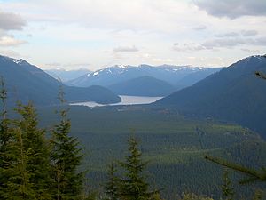
Chester Morse Lake
| Chester Morse Lake | ||
|---|---|---|

|
||
| The Chester Morse Lake from Rattlesnake Ridge of view | ||
| Geographical location | King County , Washington (USA) | |
| Tributaries | North Fork Cedar River , South Fork River , Rex River | |
| Drain | Cedar River | |
| Data | ||
| Coordinates | 47 ° 23 '13 " N , 121 ° 42' 1" W | |
|
|
||
| Altitude above sea level | 475 m | |
The Chester Morse Lake is actually a natural lake (originally Cedar Lake called) of the upper catchment area of Cedar River in King County in the State of Washington . Lake level was originally 466 meters above sea level, but was raised to 475 meters when the Cedar River was dammed in 1900. Chester Morse Lake is more than 4 miles long and is mainly fed by the North Fork and South Fork Cedar Rivers (coming from the east) and the Rex River (coming from the south). The lake is part of the water supply for the greater Seattle area.
history
Located in the upper catchment area of the Cedar River, Chester Morse Lake is dammed by a walled dam; In addition, an overflow channel has been built for control. The lake now serves as a water reservoir and drives a 30 megawatt power plant.
Natural Cedar Lake was formed about 14,000 years ago by damming a terminal moraine that was formed by an alpine glacier that reached down the Cedar River Valley from the high elevations of the Cascade Range.
ecology
Because fish migration to Chester Morse Lake is blocked upstream by Cedar Falls, fish populations downstream are isolated from those in the lake. The populations of bull trout and “pygmy whitefish” ( Prosopium coulterii ) were separated from other populations in Chester Morse Lake at least 13,000 years ago and now represent unique gene pools of these species. Both populations live in the deeper regions of the lake.
The level of Chester Morse Lake fluctuates an average of about 20 ft (6.1 m) annually. The flooding of the Cedar and Rex River deltas had a significant impact on aquatic and amphibious habitats. Changes in the management of the lake in the last 15 years have led to a higher lake level and resulted in a retreat of the sedge and willow communities in the delta. The flooding of the Cedar and Rex River beds in and above the delta led to progressive sedimentation, which can have a negative impact on bull trout eggs. Studies to investigate these effects are in progress.
Other lakes in the catchment area
Smaller lakes in the upper catchment area
Above the Cedar Falls, there are several sub-alpine lakes in ausgeschürften of alpine glaciers Karen occur in the upper valleys. None of these lakes are inhabited by fish, but all of them contain amphibians, including the American cascade frog ( Rana cascadae ) and the north-western cross-toothed newt ( Ambystoma gracile ) as well as the Washington landmark “Pacific tree frog” ( Pseudacris regilla ).
Findley Lake and its drainage basin have been places of intense scientific exploration since the early 1970s when they were designated as study sites by the International Biological Program . The research program expired in recent years.
Walsh Lake
Walsh Lake is the largest lake in the lower basin, covering 68 acres. With eleven proven species, it has the highest diversity of fish of all lakes in the catchment area. A population of the Kokanee (the stationary form of the sockeye salmon ) lives in Walsh Lake and spawns in its main tributary, Webster Creek. Researchers at the University of Washington have found that the Walsh Lake at the last holomiktischen belongs lakes of the lowlands in the Puget Sound region.
14 Lakes
The "14 Lakes" consist of five small lakes measuring 0.4 acres (0.16 ha) ... 3.6 acres (1.5 ha) in size. (They are named for their location in section 14 of the parish rank system.) These lakes lie in depressions and may have formed as dead ponds when the great glaciers that once covered Puget Sound retreated during the Pleistocene . The dead ponds were formed from large “stranded” glacial ice blocks that were buried by washed out glacial sediments, left a depression and then melted.
None of these lakes have permanent inflows or outflows. The water levels of the 14 lakes fluctuate seasonally and between individual years, depending on the amount of precipitation and the groundwater inflows and outflows. Because bushes and trees cannot settle permanently with the periodic fluctuations in water height, strongly heterogeneous societies of herbaceous plants can be found on the banks that are adapted to such conditions.
Due to the rarity of the habitats of standing waters in the surrounding landscape, the 14 lakes offer important aquatic habitats for the region, especially for amphibians. These lakes are an important refuge for amphibian populations in the area because the 14 lakes have not been populated by fish or by the non-indigenous bullfrogs, which eat amphibian eggs and larvae and thus can exterminate amphibian populations.
Individual evidence
- ^ David Chapin: Botanical Inventory of Fourteen Lakes . Cedar River Municipal Watershed, Seattle Public Utilities. February 2011. Retrieved April 24, 2018.
