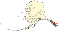
Petersburg Census Area
The Petersburg Census Area was a census area in the US state of Alaska on the Alaska Panhandle . It emerged from the Wrangell-Petersburg Census Area on June 1, 2008 , when the city of Wrangell became an independent borough and existed until 2013.
In 2010 the population was 3815. Petersburg was part of the Unorganized Borough and therefore had no administrative headquarters. The census area had an area of 23,365 km², of which 15,112 km² was land and 8252 km² was water. The largest city in the region was Petersburg .
Parts of the Tongass National Forest were in the Petersburg Census Area. To the northeast it bordered the Regional District of Kitimat-Stikine in the Canadian province of British Columbia .
Individual evidence
- ↑ Petersburg Census Area in the Geographic Names Information System of the United States Geological Survey
Web links
Commons : Petersburg Census Area - collection of images, videos and audio files
- QuickFacts on census.gov (English)

