Whittier (Alaska)
| Whittier | ||
|---|---|---|
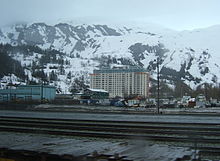
 Whittier (2008) |
||
| Location in Alaska | ||
|
|
||
| Basic data | ||
| State : | United States | |
| State : | Alaska | |
| Borough : | Unorganized Borough | |
| Coordinates : | 60 ° 46 ′ N , 148 ° 41 ′ W | |
| Time zone : | Alaska ( UTC − 9 / −8 ) | |
| Residents : | 220 (as of 2010) | |
| Population density : | 6.8 inhabitants per km 2 | |
| Area : | 51 km 2 (approx. 20 mi 2 ) of which 32.5 km 2 (approx. 13 mi 2 ) are land |
|
| Height : | 13 m | |
| Area code : | +1 907 | |
| FIPS : | 02-84510 | |
| GNIS ID : | 1415757 | |
| Website : | www.whittieralaska.gov | |
Whittier is a place in the Valdez-Cordova Census Area of the US state Alaska with 220 inhabitants.
Whittier is on the northeast coast of the Kenai Peninsula at the mouth of the Passage Canal , west of Prince William Sound . As the Barry Glacier melts, a landslide threatens to devastate the region from a tidal wave of up to 500 meters high - accompanied by an earthquake with a magnitude of 7. The municipal area extends over 51 km², of which 32.5 km² is land and 18.5 km² are water.
history
During the Second World War, the United States Army built a harbor and a train station near the Whittier Glacier, named after John Greenleaf Whittier , due to its protected location, which were also given the name "Whittier". In 1943 the Alaska Railroad reached the place. The port was used as a military facility until 1960. A tsunami, triggered by the Good Friday quake of 1964, with waves up to 13 m high, severely damaged the place and claimed 13 lives.
Two buildings built at the beginning of the 1950s characterize the townscape. The Begich Towers (formerly the Hodge Building ) and the Buckner Building , then one of the largest buildings in Alaska, housed soldiers and administrative structures and were designed as a "city under one roof". While the Buckner Building was closed in 1966 with the transfer of port operations from the Army to the General Services Administration and the associated withdrawal of soldiers, the Hodge Building was taken over by the state of Alaska and converted into an apartment building in 1973/74. With the renovation, the three-part building was renamed Begich Towers , in honor of Congressman Nick Begich , who has been missing since 1972 . Today the building is managed by the Begich Towers Condominium Association of Apartment Owners .
The 14-storey building complex of the Begich Towers, constructed by Anton Anderson , now houses not only the majority of the town's inhabitants, but also the entire infrastructure of the city, such as the administration and authorities of the community, shopping facilities, a hospital, post office, bank, church, Laundromat, a small hotel (8 suites on the top floor) and a leisure facility with swimming pool and fitness rooms. Even the school, which is located outside, can be reached via a tunnel, so that one does not have to leave the building. Because of this, Whittier received the nickname "city under one roof".
Outside the Begich Towers there is an additional supermarket, another hotel, various cafes on the harbor and a small museum in Whittier.
Transport and tourism
The port is part of the Alaska Marine Highway . There are ferry connections to Valdez , Juneau , Yakutat , Ketchikan , Bellingham . If there is sufficient demand, a seasonal non-stop ferry connection to and from Bellingham is also offered.
Today Whittier is a popular stop for cruise lines because of its rail and road links to Anchorage and inland. The Denali Express, a non-stop connection to Denali National Park offered by Princess Cruises , has its starting point here.
The Anton Anderson Memorial Tunnel through Maynard Mountain connects Whittier with the Seward Highway leading to Anchorage . The tunnel itself is part of the Portage Glacier Highway and at 4050 m the second longest highway tunnel and the longest combined rail and road tunnel in North America. In 1943, the tunnel initially only opened for trains. A train shuttle service for cars was set up in the mid-1960s, commuting between Whittier and Portage. The increase in traffic made it necessary to add a road to the railway tunnel. The opening of the expanded tunnel took place in June 2000.
Whittier has an airfield (Whittier Airport PAWR) with an unpaved runway around 450 m long, as well as a dock for seaplanes .
Various private providers offer sightseeing tours to glaciers and islands as well as fishing and hunting tours. Boats and kayaks in various designs can be rented.
swell
Web links
Individual evidence
- ↑ 2010 Demographic Profile Data. US Census Bureau, accessed May 30, 2013 .
- ↑ Megatsunami threatens holiday region accessed on June 11, 2020
- ↑ Website


