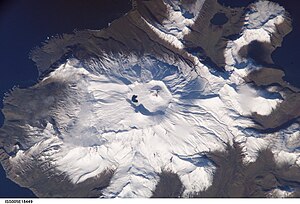
Akutan Island
| Acute | ||
|---|---|---|
| NASA image of Mount Akutan | ||
| Waters | Pacific Ocean | |
| Archipelago | Aleutian Islands | |
| Geographical location | 54 ° 8 ′ N , 165 ° 55 ′ W | |
|
|
||
| length | 31 km | |
| width | 24 km | |
| surface | 334 km² | |
| Highest elevation | Akutan Peak 1303 m |
|
| Residents | 1027 (2010) 3.1 inhabitants / km² |
|
| main place | Acute | |
| Mount Akutan | ||
Akutan Island is an island in the Fox Islands , a group of islands in the eastern Aleutian Islands , Alaska . The island is about 31 km long, up to 24 km wide and has a land area of 334.13 km². It is the fourth largest of the Fox Islands and the largest of the Krenitzin Islands , a subgroup of the Fox Islands . The island is inhabited by 713 people, all of whom live in Akutan on the east side of the island. To the southwest, Akutan Pass separates the island from Baby Islands , Unalga Island, and Unalaska Island ; in the northeast it separates Akun Strait from Akun . The western part of the island is dominated by the very active stratovolcano Mount Akutan , whose last major lava - eruption in 1979 took place. In Hot Springs Bay Valley there are hot springs and fumaroles .
PK Krenitsyn and MD Levaschow reported in 1768 that Akutan could be a name from the Aleutian language Unangan Tunuu and could be derived from the word "hakuta" which, according to RH Geoghegan, means "I made a mistake".
Web links
- Nautical map of the islands
- Akutan Island: Blocks 1052 and 1053, Census Tract 1, Aleutians East Borough, Alaska US Census 2000
- Comment on the construction of the new airport and port on Akutan (tagesschau) ( Memento from November 27, 2012 in the Internet Archive )


