Fox Islands (Alaska)
| Fox Islands | ||
|---|---|---|
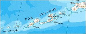
| Map of the Fox Islands | ||
| Waters | North pacific | |
| archipelago | Aleutian Islands | |
| Geographical location | 53 ° 40 ′ N , 167 ° 15 ′ W | |
|
|
||
| Number of islands | 14th | |
| Main island | Amaknak Island | |
| Total land area | 545,596 | |
The Fox Islands are the closest to the North American mainland islands of the Aleutian Islands . The islands belong to Alaska ( USA ) and are located immediately east of the Islands of Four Mountains .
The islands, inhabited by the Aleutians for centuries, were only discovered in 1741 by the Dane Vitus Bering , who was looking for new hunting grounds for Russian fur traders on behalf of the Russian Navy . The larger islands of the group are from west to east: Umnak , Unalaska , Amaknak , Akutan Island , Akun , Unimak and Sanak Island .
Fox Islands (German: Fuchsinseln) is the English translation of Лисьи острова, as Russian researchers and fur traders called the islands in the 18th century.
Historical earthquakes
On March 7, 1929 at 01: 34: 37.9 UTC , an earthquake with a magnitude of 7.8 on the Richter scale occurred here . The quake was felt on board several ships and was very violent in Dutch Harbor , Alaska. A small tsunami was recorded in Hilo , Hawaii .
On March 9, 1957 at 20: 39: 16.5 UTC, an earthquake with a magnitude of 7.1 on the Richter scale occurred here. The earthquake was felt on Adak Island .
Individual evidence
- ↑ Earthquake of March 7, 1929 ( memento of September 9, 2009 in the Internet Archive ), accessed on March 29, 2009, 1:10 p.m.
- ↑ Earthquake of March 9, 1957 ( memento of September 9, 2009 in the Internet Archive ), accessed on March 29, 2009, 1:10 p.m.

