Unalaska Island
| Unalaska | ||
|---|---|---|
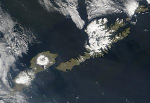
| Satellite image of Unalaska (right) and Umnak (left) | ||
| Waters | Pacific Ocean | |
| Archipelago | Fox Islands | |
| Geographical location | 53 ° 54 ′ N , 166 ° 32 ′ W | |
|
|
||
| surface | 2 721 km² | |
| Highest elevation |
Mount Makushin 2036 m |
|
| Residents | 1759 (2000) <1 inh / km² |
|
| main place | Unalaska | |
| The main town of Unalaska | ||
Unalaska Island is an island of the Fox Islands in the west-east center of the Aleutian Islands , which are southwest of Alaska and belong to the United States . The island is 2721 km² in size. In the north-east of the island, facing the Bering Sea, is the city of Unalaska , which has largely spread to the port island of Amaknak .
history
In 1759 the islands of Unalaska and Amaknak housed 24 settlements with over 1000 Aleut inhabitants. The Alëuten or Unangan have lived on the island of Unalaska for thousands of years. The Russian fur trade reached Unalaska when Stepan Glotov landed with his crew on August 1, 1759.
On June 3, 1942, during World War II , Unalaska was attacked by Japanese forces . Almost all of the locals were sent to Southeast Alaska for the duration of the war.
geography
The Bay of Unalaska flows into the Aktuan Pass, which borders the island in the northeast and in which the small island of Unalga is located. In the south, the narrow Umnak Pass separates Unalaska from the neighboring island of Umnak . In front of this pass - approx. 80 km southwest of Unalaska, also on the side facing the Bering Sea - lies the small town of Chernofski at the foot of Mount Aspird (654 m).
The largest elevation on the island is the Makushin volcano at 2036 m above sea level .
On December 8, 2004, the Malay cargo ship Selendang Ayu broke up off Unalaska and caused an oil spill due to the heavy oil spill.
Web links
- Unalaska ( Memento from December 23, 2010 in the Internet Archive ) in the island encyclopedia www.oceandots.com (English)


