
Sendai
| Sendai-shi 仙台 市 |
|||
|---|---|---|---|
 |
|||
| Geographical location in Japan | |||
|
|||
| Region : | Tōhoku | ||
| Prefecture : | Miyagi | ||
| Coordinates : | 38 ° 16 ' N , 140 ° 52' E | ||
| Basic data | |||
| Surface: | 786.30 km² | ||
| Residents : | 1,090,263 (October 1, 2019) |
||
| Population density : | 1387 inhabitants per km² | ||
| Community key : | 04100-9 | ||
| Postal code area : | 980-0011-989-3124 | ||
| Symbols | |||
| Flag / coat of arms: |
 |
||
| Tree : | Japanese zelkove | ||
| Flower : | Hagi shrub | ||
| Insect : | Bell Cicada | ||
| Bird : | cuckoo | ||
| town hall | |||
| Address : |
Sendai City Hall 3 - 7 - 1 , Kokubun-chō Aoba-ku , Sendai -shi Miyagi 980-8671 |
||
| Website URL: | http://www.city.sendai.jp/ | ||
| Location of Sendais in Miyagi Prefecture | |||
 |
|||

Sendai ( Japanese 仙台 市 , -shi ) is a city and the administrative seat of the Japanese prefecture of Miyagi .
Sendai is the largest city in the Tōhoku region and is located on the narrow strip of land between the coast of the Pacific ( Sendai Bay ) and the mountains.
geography
City structure
The city of Sendai is divided into 5 districts ( Ku ). These are:

|
Code with check digit |
Surname | Area (in km²) | population | Population density (inh / km²) |
||
|---|---|---|---|---|---|---|
| Rōmaji , | Kanji | October 01, 2018 | October 01, 2018 | 10/01/2015 | ||
| 04101-7 | Aoba-ku | 青葉 区 | 302.24 | 311,047 | 310.183 | 1026.3 |
| 04102-5 | Miyagino-ku | 宮城 野 区 | 58.19 | 196,578 | 194.825 | 3348.1 |
| 04103-3 | Wakabayashi-ku | 若 林区 | 50.86 | 137.494 | 133,498 | 2624.8 |
| 04104-1 | Taihaku-ku | 太白 区 | 228.39 | 229,664 | 226,855 | 993.3 |
| 04105-0 | Izumi-ku | 泉 区 | 146.61 | 213,886 | 216,798 | 1478.7 |
| 04100-9 | Sendai-shi | 仙台 市 | 786.30 | 1,088,669 | 1,082,159 | 1376.3 |
The Miyagino-ku and Wakabayashi-ku boroughs are on the coast. The district of Taihaku-ku extends over the entire southern part of the city and comes up to a distance of 3 km from the coast.
The densely populated, urban developed area of the city begins more than 4 km inland from the coast, and the city center is 12 km from the coast. In the majority of the country between the coast and the Tōhoku Expressway ( Tohoku Expressway is located), which divides the eastern part of the city from north to south, is agricultural land.
history
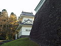
Sendai was founded as a castle town by the powerful feudal prince Date Masamune . For reasons of defense, Masamune had Sendai Castle (Aobajō / 青葉 城 , "Castle of the Green Leaves") built in 1601 one hundred meters above the city on the Aoba hill. The Hirose River flows next to the elevation.
In 1611 Sendai Castle was damaged by the Keicho earthquake , which was followed by a tsunami.
In the Edo period , the chronology records the collapse of the stone walls of Sendai Castle six times (1611, 1646, 1668, 1717, 1835 and 1855). In addition, damage to the castle town was recorded for the years 1731, 1736, 1793 and 1861.

In the Meiji period , the (- ken ) Sendai prefecture , which emerged from the principality (- han ) Sendai , was renamed Miyagi after the district in which its administrative seat was located when it was expanded to include parts of further ex-principalities / prefectures in 1871/72 . Sendai County ( 仙台 区 , Sendai- ku ) was separated from Miyagi County in 1878. From it emerged in 1889, with the introduction of today's community forms in the great Meiji regional reform, today's independent city (- shi ) Sendai with then 86,352 inhabitants. Because Sendai was already the largest city in the Tōhoku region at that time , the city became a capital of trade, education and politics. At the site of the castle at that time there was a garrison and the University of Tōhoku .
To mark the centenary of the establishment of the city of Sendai, in 1989 it was named seirei shitei toshi , a “major city by government decree” and thus divided into districts.

During the Second World War , the city was bombed several times in July 1945 by the United States Army Air Forces (USAAF). The attack with the most serious consequences was an area bombardment with napalm bombs on July 19, 1945. The attacks destroyed around 22% of the urban area and left 2,755 dead and 57,321 injured. The incendiary bombs burned around 13 km 2 of the city. (see air raids on Japan )
Tsunamis

Right : Expected area (red) and area actually flooded by the Tōhoku tsunami 2011 (yellow) with the Namiwake shrine (red arrow), in front of which the tsunami that penetrated 5 km inland stopped.

Historical tsunami experiences
The local geomorphology of the city of Sendai and its suburbs is characterized by a fluvial lowland and a low -relief coastal plain formed by the rivers Abukuma , Natori and Nanakita , where tsunami waves can sometimes penetrate far inland.
In the past, the Sendai area had suffered numerous flood and tsunami disasters. As evidenced by the Nihon Sandai Jitsuroku , the Jōgan tsunami in 869 flooded the Sendai coastal plain and killed over 1,000 people, but no historical information is known about the tsunami height or the size of the tsunami flood areas in the case of the Jōgan tsunami and the Keicho tsunami .
In 1835, the Namiwake Shrine (浪 分 神社) was built at a distance of 5.5 km from the coast in a low-lying area of the Wakabayashi district (仙台 市 若 林区) of the city of Sendai to "protect" from a future tsunami . Deposits of the Jōgan tsunami from the year 869 were found 200 to 300 meters in front of the shrine . The Namiwake Shrine was originally built in 1703 at a different location , but it was flooded by the Keichō-Sanriku tsunami in 1611 , which claimed around 1,700 lives.
2011 Tōhoku disaster
Extent of flooding and damage
While only a narrow strip of coastline was expected as a flood area in the event of a tsunami in the Sendai area, the tsunami triggered by the Tōhoku earthquake on March 11, 2011 in the Sendai coastal plain penetrated much deeper - more than 5 km - into it Inland ahead, including just before the Namiwake Shrine in Sendai-Wakabayashi. Although the 2011 Tōhoku tsunami was stronger than expected, the Namiwake Shrine survived the earthquake and tsunami of 2011.
The tsunami flooded the entire Sendai Plain, which, with its urban center of Sendai with a population of one million, was the largest city and the most densely populated area in the Tōhoku region. In the city of Sendai, it flooded an area in which (as of 2010) 19,580 people had lived in 6,640 households, of which 12,830 people in 4,720 households in the Miyagino-ku district (宮城 野 区) and 6,750 people in 1,920 households in the Wakabayashi district. ku (若 林区). Around 18% of the people living in the floodplains in Sendai were 65 years of age or older in 2010. Compared to other regions in the prefectures of Iwate and Miyagi that were flooded by the tsunami in 2011, the proportion of the population previously living in floodplains (especially high in Higashimatsushima at 67.1%) in Sendai was 1.9% (and in Miyagino-ku with 6.7% or in Wakabayashi-ku with 5.1%) much lower.
The number of completely destroyed residential buildings is put at 30,034, that of partially destroyed at 109,609.
In the Wakabayashi-ku district in southeast Sendai, bordering the Natori River to the south, the tsunami advanced more than 3 km inland from the coast, with the height of the tsunami tracks gradually decreasing as the tsunami waves moved away from the coast, such as this could also be seen in other cities belonging to the Sendai Plain such as Natori and Watari . As a coastal region, Wakabayashi-ku suffered severe damage from the tsunami, particularly around the Arahama district. Six offshore breakwaters were used locally on the coastline bordering the ocean to the east.
The most important coastal protection systems were in the concrete block revetments along Arahama Beach. A pine forest directly inland adjacent to the revetments offered additional protection. The concrete protection systems on Arahama Beach failed in several places, however, the tsunami washed out the sand filling and washed concrete blocks up to 100 m into the pine forest near the coast. The flat lowlands encouraged the tsunami to advance up to 5 km inland. Arahama was a residential area about 10 km from Sendai city center, beginning directly on the Pacific coast and about one kilometer inland, in which around 800 households with around 2,200 inhabitants had settled around the historic Teizan Canal, which was founded by Date Masamune and in this area of the coastline runs parallel to the sea shore at a distance of around 450 meters. While coastal forests typically stretch between the Teizan Canal and the shoreline, providing a degree of shelter, houses in Arahama extend beyond the canal all the way to the seashore. In the vicinity of the coastline, flood heights of 9.32 m and 8.43 m were measured and a lot of driftwood (up to 70 cm in diameter) was found, which came from the coastal forests between the Teizan Canal and the seashore. A flood height of 5.44 m was measured at the mouth of the Natori River, on the banks of which a lot of debris accumulated. Most of the buildings in Arahama were destroyed, with the exception of a few houses and the Arahama Elementary School. Many wooden houses collapsed or were later demolished.
Immediately after the earthquake, the Japanese broadcaster NHK sent a helicopter camera crew to the Sendai coast to broadcast the spread of the tsunami to the coast. The tsunami reached the Sendai coast about an hour after the earthquake and the NHK crew managed to film the moment of the tsunami attack on the coast. The camera team flew along the Natori River and was able to document the advance and emergence of the tsunami along the river. In particular, it filmed the tsunami to the left of the Natori in Sendai-Fujitsuka and to the right of the river in Natori-Yuriage and Natori-Kozukahara. The video has been broadcast worldwide and is included in the NHK video archive. It has been scientifically evaluated and provides important information on the manner in which the tsunami penetrated inland and on its flow characteristics during local flooding.
Victim
The fire and disaster control authorities reported 685 dead and 180 missing in their damage report on May 19. The number of deaths increased to 923 in the later damage record, while 27 people were still missing.
Measured against the total population of Sendai, which was given as 1,045,986 in the 2010 census, the casualty rate from the 2011 disaster was 0.1% if all the dead and in the 157th FDMA damage report of March 7, 2018 Missing persons are taken into account or 0.07% if the victims recorded in the 153rd FDMA damage report of March 8, 2016 (923 dead and 27 missing) minus the catastrophe-related deaths reported by the Reconstruction Agency (RA) are taken into account, whereby the number is 681 dead and missing. With the same data base, but based solely on the flood area of the tsunami in Sendai, which covered an area of 52 km 2 , the casualty rate was 2.27%.
Well over 600 people died in the Miyagino-ku and Wakabayashi-ku districts alone. A victim rate of 4.29% was reported for the Wakabayashi district.
evacuation


The Sendais coastal area was notable for two contrasting examples of evacuation building designs:
- In the vicinity of Sendai Port in Miyagino-ku, a precast concrete sports hall was signposted as an evacuation site. This building was located 380 m from the coast on the inland side of the beach near the small (150 m wide) mouth (150 m wide) of the Nanakita River (七 北 田 川). A series of dikes divided part of the estuary into individual ponds and were breached by the tsunami. The evacuation building suffered no visible damage to load-bearing components due to the tsunami, but due to its function as a sports hall it was single-story and equipped with a high ceiling, so that in the main part of the building there was no upper floor and on the second floor of the annex building only very little floor space. which is why it was unsuitable for vertical evacuation. In addition, apart from a small maintenance ladder, there was no outside access to the roof.
- The Sendai-Arahama (仙台 市立 荒 浜 小学校) elementary school, which was built according to the high structural standards applicable to schools in Japan and is designated as an evacuation site, was the only building in the Arahama district (若 林区) on higher ground and withstood the tsunami , which flooded and damaged it up to the ceiling of the second floor, although the four-storey reinforced concrete building of the school, which was founded in 1873 and had 91 students before the disaster, is around 700 m away from the coastline. In the longitudinal direction of the building (perpendicular to the coastline) rubble and several vehicles penetrated the building, which reached a considerable flow velocity through the central corridor within the central ground floor corridor. Immediately after the earthquake, the school building served as an important evacuation building due to its height and flatness for the wider area, into which many residents, students and school employees who lived nearby fled. During the tsunami, the school building, which was not clearly marked as a vertical evacuation site, fulfilled its secondary function as a building for vertical evacuation. The building had roof railings, direct access to the roof via a large, conspicuously painted steel staircase at the back (north side) and two roof sirens. While the tsunami reached the second floor, all those evacuated to the school managed to escape to the roof of the school. As 380 (according to other data: 320) people survived by evacuating them to the roof of the school, the school is considered an example of successful evacuation. In order to face future catastrophes, the city received the ruins of the school building as a memorial and opened it to the general public.
Relocation and Reconstruction

Around 57,000 houses were damaged or destroyed by the earthquake and tsunami on March 11, 2011. As part of its reconstruction concept, the Sendai city government designated an area of around 1,200 ha as a tsunami-prone area in December 2011, in which, according to arithmetical tsunami simulations, another tsunami of the same magnitude as on March 11, 2011, despite structural protection measures, would have flooding heights of over two meters deep would arise. In these risk areas, where around 1,500 families had lived before the disaster, the city government has now prohibited people from building housing. Instead, the city government promoted the resettlement of these 1,500 families from these so-called risk areas to higher and safer terrain and the reconstruction there with various programs: As part of individual resettlement, the families affected could buy safe land for themselves and cultivate them according to their own ideas, with the city administration bought their previous plots of land from the endangered areas and granted grants for grants for the relocation as well as the interest amounts for new housing loans. As part of the group relocation, the people affected build houses at locations developed by the government and are supported as in the previous model. As part of social housing, the government finally made public rental apartments available to residents who could not find the means to build new houses. As of May 2013, 49 percent of families in risk areas had opted for group relocation, 49 percent for individual relocation and 27 percent for social housing.
In the areas bordering the risk areas, in which, according to calculated tsunami simulations, another tsunami of the same magnitude as on March 11, 2011 would result in flooding heights of up to two meters in spite of structural protective measures, the city government supported the 2,300 families living there Provision of subsidies for disaster control measures such as increasing the soil level or building mounds of earth on residential properties. Alternatively, the people there had the opportunity to find a new piece of land and build on it according to their own ideas, while the city administration supported them with grants for resettlement and interest payments for new housing loans. As part of social housing, the city administration built 3,000 public rental units for residents who cannot build new houses.
In the hilly areas, where around 5,500 houses had to be badly damaged and rebuilt by landslides triggered by the earthquake, the city administration planned to rebuild them through public works or through subsidies that contributed 90 percent of the costs.
- Gallery: Devastation in Sendai after the earthquake and tsunami of March 11, 2011:

Satellite image of the tsunami damage in the port of Sendai from March 12, 2011 (magenta: rubble; blue: floods)

Dykes in Sendai before (left) and after the tsunami, which destroyed 190 of the 300 km of coastal defenses in Japan.

Aerial photograph of the flooded region over the port of Sendai (Photo: March 12, 2011)
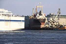
The South Korean cargo ship Glovis Mercury, washed onto the quay in Sendai harbor by the tsunami (Photo: April 25, 2011)

Drifting house (Photo: March 14, 2011)


Politics and administration
(as of September 9, 2019)
As a designated city ( seirei shitei toshi ), Sendai is divided into districts (- ku ) , namely: Aoba-ku , Miyagino-ku , Wakabayashi-ku , Taihaku-ku and Izumi-ku .
Mayor of Sendai City (Sendai-shichō) is the former Democratic MP Kazuko Kōri . In 2017 she replaced Emiko Okuyama , who no longer ran after two terms. Kōri won the July 23 election with center-left support against center-right-backed entrepreneur Hironori Sugawara and two other candidates.
The Parliament of Sendai City (Sendai-shi gikai) has 55 members from five constituencies corresponding to the city districts. In the election on August 25, 2019, with voter participation (36.07%) slightly recovering from the record low of 2015 (35.83%), the Liberal Democratic Party (LDP) remained the strongest force with slight losses with 19 seats. In each of the three constituencies, one KDP candidate received the highest number of votes. The Kōmeitō won nine seats, KDP and KPJ each six, the SDP five. All three candidates for the DVP were elected, plus seven without a formal party nomination, including three with LDP election recommendations.
The districts of the city of Sendai, which act as constituencies, elect 24 of the 59 MPs to the parliament of Miyagi Prefecture (Miyagi-ken gikai) : The seven-mandate constituency Aoba-ku is the constituency with the prefecture-wide highest number of seats, the districts Taihaku and Izumi each elect five MPs , Miyagino four, and Wakabayashi three.
In elections to the House of Representatives ( Shūgiin ) , the lower house of the National Assembly, the city of Sendai extends into three constituencies of Miyagi Prefecture since a reorganization in the 2017 election : The Liberal Democrat represents the constituency of Miyagi 1 with the district of Aoba and the eastern part of Taihaku-ku Tōru Doi (2017 46.2% of the vote), constituency 2 with the other three districts of Ken'ya Akiba (50.3%), also a Liberal Democrat. The Constitutional Democrat Akiko Okamoto (36.3%), who was defeated in the 1st constituency , won a seat in the proportional representation in the Tōhoku block. Parts of the Taihaku district have been part of constituency 3 since 2017, which includes the entire south of Miyagi and has been represented, with interruption, by the Liberal Democrat Akihiro Nishimura since 2003 .
traffic
- air
- Sendai Airport : international flights to neighboring countries depart from here
- Subway
There are two subway lines in the city (see: Sendai Subway ).
- train
Sendai is one of the most important stations on the JR Tōhoku-Shinkansen route.
- Street
climate
| Sendai | ||||||||||||||||||||||||||||||||||||||||||||||||
|---|---|---|---|---|---|---|---|---|---|---|---|---|---|---|---|---|---|---|---|---|---|---|---|---|---|---|---|---|---|---|---|---|---|---|---|---|---|---|---|---|---|---|---|---|---|---|---|---|
| Climate diagram | ||||||||||||||||||||||||||||||||||||||||||||||||
| ||||||||||||||||||||||||||||||||||||||||||||||||
|
Average monthly temperatures and rainfall for Sendai
Source: Japan Meteorological Agency
|
|||||||||||||||||||||||||||||||||||||||||||||||||||||||||||||||||||||||||||||||||||||||||||||||||||||||||
Culture
The University of Tōhoku is located in Sendai . The Sendai Mediatheque , designed by the Tokyo architect Toyo Ito and inaugurated in 2001, is internationally renowned and important .
Some of the most famous culinary specialties from Sendai include gyutan , thinly sliced and grilled cow tongue; Sasakamaboko , a fish sausage wrapped in leaves; and zundamochi , mochi balls with a light green edamame paste.
The Sendai City Tomizawa Site Museum of Archeology is located in the Taihaku district . a. 20,000 year old forest remains can be seen.
The most important daily newspaper is the Kahoku Shimpō .
The Daikannon statue in the north of the city was the largest statue in Asia when it was completed on September 1, 1991 .
Economy and Infrastructure
The economy in Sendai is dominated by trade and service companies. Only a few major companies have their headquarters there; branches of companies located elsewhere dominate.
The headquarters of the energy supplier Tōhoku Denryoku is located in Sendai .
Universities and colleges
Sports
- Baseball - Sendai is home to the Tōhoku Rakuten Golden Eagles baseball club of the Pacific League , whose games are played at Sendai Miyagi Stadium .
- Soccer - Sendai is the home of the J. League Vegalta Sendai soccer club , whose games are played at Yurtec Stadium .
- Sendai 89ers (basketball)
Personalities
Town twinning
-
 Acapulco , Mexico
 -
 Changchun , People's Republic of China
 -
 Dallas , United States
 -
 Gwangju , South Korea
 -
 Minsk , Belarus
 -
 Oulu , Finland
 -
 Rennes , France
 -
Riverside , United States
-
 Tainan , Republic of China (Taiwan)
gallery

Sendai Railway Station
lock

Goshiki

Goshiki

Hirose River

Steam locomotive C60 1 in Sakuragaoka Park


Neighboring cities and communities
Web links
- Official City Website (Japanese, English, Chinese, Korean, Russian, and French)
- 10 万分 1 浸水 範 囲 概況 図 , 国土 地理 院 ( Kokudo Chiriin , Geospatial Information Authority of Japan, formerly: Geographical Survey Institute = GSI), www.gsi.go.jp: 地理 院 ホ ー ム> 防災 関 連> 平 成 23 年 (2011年) 東北 地方 太平洋 沖 地震 に 関 す る 情報 提供> 10 万分 1 浸水 範 囲 概況 図:
- The GSI published here a map with Sendai ( 浸水範囲概況図13 ), on the (z. B. Miyagino ku /宮城野区and Wakabayashi-ku /若林区) in 2011 flooded the Tōhoku tsunami areas based on from evaluations of aerial photographs and satellite images are drawn in, as far as this was possible.
Individual evidence
- ↑ a b c d e f g h i j k l m n o p q r Stuart Fraser, Alison Raby, Antonios Pomonis, Katsuichiro Goda, Siau Chen Chian, Joshua Macabuag, Mark Offord, Keiko Saito, Peter Sammonds: Tsunami damage to coastal defenses and buildings in the March 11th 2011 Mw9.0 Great East Japan earthquake and tsunami . In: Bulletin of Earthquake Engineering . tape 11 , 2013, p. 205-239 , doi : 10.1007 / s10518-012-9348-9 .
- ↑ a b c d Fumihiko Imamura, Suppasr Anawat: Damage Due To The 2011 Tohoku Earthquake Tsunami And Its Lessons For Future Mitigation . In: Proceedings of the International Symposium on Engineering Lessons Learned from the 2011 Great East Japan Earthquake, March 1-4, 2012, Tokyo, Japan . 2012, p. 21-30 . , (Keynote Presentation, URL: http://www.jaee.gr.jp/event/seminar2012/eqsympo/proceedings.html ; complete download: http://www.jaee.gr.jp/event/seminar2012/eqsympo/Proc_GEJES .zip ).
- ↑ Sendai City: 仙台 市 の あ ゆ み
- ↑ a b c d e f g h Anawat Suppasri, Nobuo Shuto, Fumihiko Imamura, Shunichi Koshimura, Erick Mas, Ahmet Cevdet Yalciner: Lessons Learned from the 2011 Great East Japan Tsunami: Performance of Tsunami Countermeasures, Coastal Buildings, and Tsunami Evacuation in Japan . In: Pure and Applied Geophysics . tape 170 , no. 6-8 , 2013, pp. 993-1018 , doi : 10.1007 / s00024-012-0511-7 . (Published online July 7, 2012).
- ↑ a b Anawat Suppasri, Nobuo Shuto, Fumihiko Imamura, Shunichi Koshimura, Erick Mas, Ahmet Cevdet Yalciner: Lessons Learned from the 2011 Great East Japan Tsunami: Performance of Tsunami Countermeasures, Coastal Buildings, and Tsunami Evacuation in Japan . In: Pure and Applied Geophysics . tape 170 , no. 6-8 , 2013, pp. 993-1018 , doi : 10.1007 / s00024-012-0511-7 . (Published online on July 7, 2012), here: p. 1015, Figure 32. License: Creative Commons Attribution 2.0 Generic (CC BY 2.0).
- ↑ 東 日本 大 震災 記録 集 ( Memento from March 23, 2018 on WebCite ) , 総 務 省 消防 庁 (Fire and Disaster Management Agency), March 2013, here in Chapter 2 (第 2 章 地震 ・ 津 波 の 概要) the subsection 2.2 (2.2津 波 の 概要 (4)) ( PDF ( Memento from March 27, 2018 on WebCite )), p. 63, Fig. 13.
- ↑ Overview: Lessons from the Great East Japan Earthquake . In: Federica Ranghieri, Mikio Ishiwatari (Ed.): Learning from Megadisasters - Lessons from the Great East Japan Earthquake . World Bank Publications, Washington, DC 2014, ISBN 978-1-4648-0153-2 , Chapter 17, pp. 1–21 , doi : 10.1596 / 978-1-4648-0153-2 ( work accessible online on Google Books [accessed April 3, 2018]). , License: Creative Commons Attribution CC BY 3.0 IGO; here: p. 17, Map O.2: "Actual inundation areas were much larger than predicted" (source: Cabinet Office).
- ↑ a b Nobuhito Mori, Tomoyuki Takahashi, Tomohiro Yasuda, Hideaki Yanagisawa: Survey of 2011 Tohoku earthquake tsunami inundation and run ‐ up . In: Geophysical Research Letters . tape 38 , no. 7 , 2011, p. 1-6 , doi : 10.1029 / 2011GL049210 . (Published online September 27, 2011).
- ↑ a b Nobuhito Mori, Daniel T. Cox, Tomohiro Yasuda, Hajime Mase: Overview of the 2011 Tohoku Earthquake Tsunami Damage and Its Relation to Coastal Protection along the Sanriku Coast . In: Earthquake Spectra . tape 29 , S1, 2013, pp. 127-143 , doi : 10.1193 / 1.4000118 .
- ↑ H. Murakami, K. Takimoto, A. Pomonis: Tsunami Evacuation Process and Human Loss Distribution in the 2011 Great East Japan Earthquake - A Case Study of Natori City, Miyagi Prefecture . In: 15th World Conference on Earthquake Engineering . 2012 ( iitk.ac.in [PDF]).
- ↑ a b c 平 成 23 年 (2011 年) 東北 地方 太平洋 沖 地震 (東 日本 大 震災) に つ い て (第 157 報) ( Memento from March 18, 2018 on WebCite ) ( PDF ( Memento from March 18, 2018 on WebCite )),総 務 省 消防 庁 (Fire and Disaster Management Agency), 157th report, March 7, 2018.
- ↑ a b c d e f g h i Takahito Mikami, Tomoya Shibayama, Miguel Esteban, Ryo Matsumaru: Field survey of the 2011 Tohoku earthquake and tsunami in Miyagi and Fukushima prefectures . In: Coastal Engineering Journal . tape 54 , no. 1 , 2012, p. 1250011-1-1250011-26 , doi : 10.1142 / S0578563412500118 . (Published March 29, 2012).
- ↑ a b c d e f g h i j 荒 浜 地区 と 荒 浜 小学校 - Arahama Area and Arahama Elementary School ( Memento from June 23, 2018 on WebCite ) , city.sendai.jp, undated.
- ↑ Dinil Pushpalal: A Journey through the Lands of the Great East Japan Earthquake . In: Dinil Pushpalal, Jakob Rhyner, Vilma Hossini (eds.): The Great Eastern Japan Earthquake 11 March 2011: Lessons Learned And Research Questions - Conference Proceedings (11 March 2013, UN Campus, Bonn) . 2013, ISBN 978-3-944535-20-3 , ISSN 2075-0498 , pp. 14-26 .
- ↑ a b Shunichi Koshimura, Satomi Hayashi, Hideomi Gokon: The impact of the 2011 Tohoku earthquake tsunami disaster and implications to the reconstruction . In: Soils and Foundations . tape 54 , no. 4 , August 2014, p. 560-572 , doi : 10.1016 / j.sandf.2014.06.002 . (Published online July 22, 2014).
- ↑ Shunichi Koshimura, Satomi Hayashi, Hideomi Gokon: The impact of the 2011 Tohoku earthquake tsunami disaster and implications to the reconstruction . In: Soils and Foundations . tape 54 , no. 4 , August 2014, p. 560-572 , doi : 10.1016 / j.sandf.2014.06.002 . (Published online July 22, 2014). With reference to the NHK video archive: www9.nhk.or.jp/311shogen/map/#/evidence/detail/D0007030024_00000.
- ↑ 3.11 大 震災, 宮城 県 名 取 市, 3 月 11 日 15 時 54 分 , NHK 東 日本 大 震災 ア ー カ イ ブ ス (NHK Great East Japan Earthquake Archive), program: NHK ニ ュ ー ス (2011 年 3 月 11 日) ( 2011), location: 宮城 県 仙台 市 ・ 名 取 市 名 取 川 上空, video sequences: ニ ュ ー ス 映像, Chapter 1: 3 月 11 日 15 時 54 分, Chapter 2: 3 月 11 日 15 時 58 分, Chapter 3: 3 月11 日 16 時 02 分, Chapter 2: 3 月 11 日 16 時 07 分.
- ↑ 平 成 23 年 (2011 年) 東北 地方 太平洋 沖 地震 (第 124 報) ( Memento from March 25, 2018 on WebCite ) ( PDF ( Memento from March 25, 2018 on WebCite )), 総 務 省 消防 庁 (Fire and Disaster Management Agency), 124th report, May 19, 2011.
- ↑ 東 日本 大 震災 図 説 集 . (No longer available online.) In: mainichi.jp. Mainichi Shimbun- sha, May 20, 2011, archived from the original on June 19, 2011 ; Retrieved June 19, 2011 (Japanese, overview of reported dead, missing and evacuated).
- ↑ 平 成 22 年 国 勢 調査 - 人口 等 基本 集 計 結果 - (岩手 県 , 宮城 県 及 び 福島 県) ( Memento from March 24, 2018 on WebCite ) (PDF, Japanese), stat.go.jp (Statistics Japan - Statistics Bureau , Ministry of Internal Affairs and communication), 2010 Census, Summary of Results for Iwate, Miyagi and Fukushima Prefectures, URL: http://www.stat.go.jp/data/kokusei/2010/index.html .
- ↑ Tadashi Nakasu, Yuichi Ono, Wiraporn Pothisiri: Why did Rikuzentakata have a high death toll in the 2011 Great East Japan Earthquake and Tsunami disaster? Finding the devastating disaster's root causes . In: International Journal of Disaster Risk Reduction . tape 27 , 2018, p. 21-36 , doi : 10.1016 / j.ijdrr.2017.08.001 . (Published online on August 15, 2017), here p. 22, table 2.
- ↑ 平 成 23 年 (2011 年) 東北 地方 太平洋 沖 地震 (東 日本 大 震災) に つ い て (第 153 報) ( Memento of March 10, 2016 on WebCite ) , 総 務 省 消防 庁 (Fire and Disaster Management Agency), 153rd report, March 8, 2016.
- ↑ Anawat Suppasri, Nobuo Shuto, Fumihiko Imamura, Shunichi Koshimura, Erick Mas, Ahmet Cevdet Yalciner: Lessons Learned from the 2011 Great East Japan Tsunami: Performance of Tsunami Countermeasures, Coastal Buildings, and Tsunami Evacuation in Japan . In: Pure and Applied Geophysics . tape 170 , no. 6-8 , 2013, pp. 993-1018 , doi : 10.1007 / s00024-012-0511-7 . (Published online on July 7, 2012), here: p. 1010, Figure 24. License: Creative Commons Attribution 2.0 Generic (CC BY 2.0).
- ↑ a b c d Isao Hayashi: Materializing Memories of Disasters: Individual Experiences in Conflict Concerning Disaster Remains in the Affected Regions of the Great East Japan Earthquake and Tsunami . In: Bulletin of the National Museum of Ethnology [ 国立 民族 学 博物館 研究 報告 ] . tape 41 , no. 4 , March 30, 2017, p. 337-391 , doi : 10.15021 / 00008472 .
- ^ The Education Sector . In: Federica Ranghieri, Mikio Ishiwatari (Ed.): Learning from Megadisasters - Lessons from the Great East Japan Earthquake . World Bank Publications, Washington, DC 2014, ISBN 978-1-4648-0153-2 , Chapter 8, pp. 77–82 , doi : 10.1596 / 978-1-4648-0153-2 ( work accessible online on Google Books [accessed on April 3, 2018]). , License: Creative Commons Attribution CC BY 3.0 IGO.
- ↑ a b c d Michio Ubaura, Akihiko Hokugo, Mikio Ishiwatari, International Recovery Platform: Relocation in the Tohoku Area . In: Federica Ranghieri, Mikio Ishiwatari (Ed.): Learning from Megadisasters - Lessons from the Great East Japan Earthquake . World Bank Publications, Washington, DC 2014, ISBN 978-1-4648-0153-2 , Chapter 33, pp. 307–315 , doi : 10.1596 / 978-1-4648-0153-2 ( work accessible online on Google Books [accessed on April 3, 2018]). , here: 308f, Map 33.1: "Relocation project in Sendai City" ("Source: Sendai City"), License: Creative Commons Attribution CC BY 3.0 IGO.
- ↑ Junko Sagara, Keiko Saito: Overview: Lessons from the Great East Japan Earthquake . In: Federica Ranghieri, Mikio Ishiwatari (Ed.): Learning from Megadisasters - Lessons from the Great East Japan Earthquake . World Bank Publications, Washington, DC 2014, ISBN 978-1-4648-0153-2 , Overview, pp. 1–21 , doi : 10.1596 / 978-1-4648-0153-2 ( work accessible online on Google Books [accessed April 3, 2018]). , License: Creative Commons Attribution CC BY 3.0 IGO, here: p. 8f, Map O.3: "Dikes in Sendai before and after the tsunami of March 11, 2011" "Source: Ministry of Land, Infrastructure, Transport and Tourism, 2011. ".
- ↑ Sendai City Parliament: MPs by faction (Japanese), accessed November 13, 2019.
- ↑ Sendai elects opposition-backed Kori as next mayor, dealing another blow to Abe's LDP. In: The Japan Times . July 24, 2017, accessed March 16, 2018 .
- ↑ 2019 仙台 市 議 選 . In: NHK Senkyo Web. August 25, 2019. Retrieved November 13, 2019 (Japanese).
- ↑ 仙台 市 議会 議員 一般 選 挙 の 結果 . Sendai-shienkenyo kanri iinkai, August 26, 2019, accessed November 13, 2019 (Japanese).
- ↑ constituencies and members of parliament. In: Miyagi Prefecture Parliament. Retrieved November 13, 2019 (Japanese).
- ^ Sendai Mediatheque: Architecture
Remarks
- ↑ The Arahama district (荒 浜) in the Wakabayashi district (若 林区) of the city of Sendai (仙台 市) is not to be confused with the district of the same name (荒 浜) in the city of Watari (亘 理), which, as in the first-mentioned district, is subject to destruction caused by the Tōhoku tsunami of March 11, 2011 (Source: Takahito Mikami, Tomoya Shibayama, Miguel Esteban, Ryo Matsumaru: Field survey of the 2011 Tohoku earthquake and tsunami in Miyagi and Fukushima prefectures . In: Coastal Engineering Journal . Volume 54 , no. 1 , 2012, p. 1250011-1-1250011-26 , doi : 10.1142 / S0578563412500118 . )
Independent cities ( shi ): Higashimatsushima | Ishinomaki | Iwanuma | Kakuda | Kesennuma | Kurihara | Natori | Ōsaki | Sendai (administrative headquarters) | Shiogama | Shiroishi | Tagajō | Tome | Tomiya
Igu-gun : Marumori | Kami-gun : Kami | Shikama | Ring- tailed lemur : Shichikashuku | Zaō | Kurokawa-gun : Ōhira | Ōsato | Taiwa | Miyagi-gun : Matsushima | Rifu | Shichigahama | Motoyoshi-gun : Minamisanriku | Oshika-gun : Onagawa | Shibata-gun : Kawasaki | Murata | Ōgawara | Shibata | Toda-gun : Misato | Wakuya | Watari-gun : Watari | Yamamoto