
Higashimatsushima
| Higashimatsushima-shi 東 松 島 市 |
|||
|---|---|---|---|
 |
|||
| Geographical location in Japan | |||
|
|||
| Region : | Tōhoku | ||
| Prefecture : | Miyagi | ||
| Coordinates : | 38 ° 26 ' N , 141 ° 13' E | ||
| Basic data | |||
| Surface: | 101.86 km² | ||
| Residents : | 39,138 (October 1, 2019) |
||
| Population density : | 384 inhabitants per km² | ||
| Community key : | 04214-5 | ||
| Symbols | |||
| Flag / coat of arms: |
 |
||
| Tree : | jaw | ||
| Flower : | Cherry Blossom | ||
| town hall | |||
| Address : |
Higashimatsushima City Hall 36 - 1 , Aza Kamikawado, Yamoto Higashimatsushima shi Miyagi 981-0503 |
||
| Website URL: | http://www.city.higashimatsushima.miyagi.jp/ | ||
| Location of Higashimatsushimas in Miyagi Prefecture | |||
 |
|||

Higashimatsushima ( Japanese 東 松 島 市 , - shi ) is a city in Miyagi Prefecture on Honshū , the main island of Japan .
geography

Higashimatsushima is located south of Ishinomaki and north of Sendai on Sendai Bay in the Pacific Ocean . The inhabited island of Miyato-jima belongs to the municipality .
Higashimatsushima is located in the transition zone between much steeper sloping terrain in the north and the extensive, low-lying Sendai plain in the south.
The coastal zone at Ishinomaki Bay is politically divided between the municipalities of Higashimatsushima and Ishinomaki and combines a variety of land use zones including urban and industrial areas, residential areas and rural areas. In addition to the Matsushima military airport (松 島 基地) in Higashimatsushima, there is a commercial port and a fishing port. The local economy is primarily based on fishing, the fishery products industry and agriculture.
The geomorphological nature of Ishinomaki Bay makes the area particularly prone to tsunami events, as it is a flat coastline surrounded by the two bays of Ishinomaki and Matsushima, both of which are flat and characterized by a relatively flat (smooth ) Mark the seabed. The area has an extensive hydrographic network consisting of the Kitakami (北上 川, in Ishinomaki), Jo (定 川, between Ishinomaki and Higashimatsushima), and Naruse (鳴 瀬 川, in Higashimatsushima) rivers connected by canals. Hiyoriyama Hill (日 和 山, in Ishinomaki) and the local coastal forests are the only natural barriers to tsunami waves in the tsunami-prone area.
history
The city of Higashimatsushima was created on April 1, 2005 from the merger of the communities Yamoto ( 矢 本 町 , -machi ) and Naruse ( 鳴 瀬 町 , -machi ) in Monō County .
Tōhoku earthquake and tsunami 2011

Satellite images in false color display : water or muddy water is blue / dark blue, vegetation-covered land is red, exposed ground or fallow land is brown / beige-brown and urban sealed areas or buildings are shown in silver / blue-gray.
Extent of flooding and damage

.jpg)


On March 11, 2011, the city was hit by the Tōhoku earthquake and the subsequent tsunami. Fires broke out and half of the city was flooded. Rivers and canals in the plain contributed to the expansion of the floodplain. More than 5,500 houses were completely destroyed and over 5,500 others were partially destroyed.
According to media reports, many people died of hypothermia , as the disaster cut off the electricity and gas supplies that normally provided heating in the winter.
Ships such as the Chokai Maru (鳥 海 丸), a 50-meter-long fishing training ship estimated at 2000 tons from the Kamo Fisheries High School (加 茂 水産 高校) in Tsuruoka (鶴 岡 市) in Yamagata Prefecture , were lifted over the docks by the tsunami and washed up in inhabited areas of Higashimatsushima or Ishinomaki.
The JR East - Senseki Line suffered great damage. Railways and railroad cars were washed away by the tsunami that was up to 3.7 meters high. Two trains on the Senseki Line, which connected Sendai and Ishinomaki and carried around 200 commuters and school-goers daily, were in the area at the time of the earthquake, one of which was en route to Aoba-Dori Station. The passengers followed the instructions of the driving staff to evacuate to Nobiru Elementary School, which was the closest evacuation building, but the tsunami reached this elementary school (Tōna-Nobiru). Immediately afterwards, the train derailed due to the tsunami, turned at a right angle and came to a halt when it hit a house. Another train of the Senseki line to Ishinomaki, which was stopped at this location, drove about 1.5 km from the derailed train in the direction of Ishinomaki (Tōna-Rikuzenono). This train stopped on a hill a little over 10 m high. On the advice of locals, the drivers decided to stay on the train with the passengers, thus escaping the tsunami and keeping them safe.
Victim
Up to May 20, 2011, 1,031 dead and 395 missing, up to March 2018 1,132 dead and 23 still missing were counted.
Measured against the total population of Higashimatsushima, which was given as 42,903 in the 2010 census, the casualty rate from the 2011 disaster was 2.7% if all dead and missing persons recorded in the 157th FDMA damage report of March 7, 2018 are included or 2.53% if the victims recorded in the 153rd FDMA damage report of March 8, 2016 (1,129 dead and 23 missing) minus the catastrophe-related deaths reported by the Reconstruction Agency (RA) are taken into account, which results in a The figure is 1,086 dead and missing. With the same database, but based solely on the flood area of the tsunami in Higashimatsushima, which covered an area of 37 km 2 , the casualty rate was 3.19%.
Most of the fatalities in Higashimatsushima were in the Nobiru area. Depending on the source, 323 or 500 people died in Nobiru.
In the entire Ishinomaki metropolitan area, which includes Higashimatsushima and its neighboring town Ishinomaki and Onagawa , nearly 220,000 people lived at the time of the disaster, of whom 5,300 were killed in the disaster and around 700 remained missing.
| Area in Higashimatsushima | Fatalities | Residents | Tsunami | Distance to the next evacuation site [m] | ||
|---|---|---|---|---|---|---|
| Rate [%] | number | Max. Flooding height [m] | Arrival time [min.] | |||
| Nobiru | 12.78 | 323 | 2,527 | 7.93 | 62 | 4,368 |
| Ōmagari | 4.46 | 313 | 7,019 | 4.57 | 62 | 3,394 |
| Yamoto | 0.65 | 83 | 12,736 | 0.78 | 62 | 679 |
| Akai | 0.47 | 35 | 7,424 | 0.78 | 62 | 2.128 |
| Shintona | 3.32 | 34 | 1,024 | 2.02 | 135 | 3,715 |
| Ushiami | 0.94 | 17th | 1,812 | 1.63 | 62 | 3,930 |
| Miyato | 1.16 | 11 | 950 | 1.95 | 132 | 1,375 |
| Source: Total population according to Statistics Bureau (統計局) and Director-General for Policy Planning (政策 統 括 官), 2010 census; Fatalities according to fire and disaster management agency (消防 庁 = Fire and Disaster Management Agency, FDMA); Maximum flood height and arrival time of the tsunami according to The 2011 Tohoku Earthquake and Tsunami Joint Survey Group ; Distance to the nearest evacuation site from the place of residence according to the evacuation site data from the Cabinet Secretariat Civil Protection Portal Site ( http://www.kokuminhogo.go.jp/en/pc-index_e.html ) of the Cabinet Secretariat (内閣 官 房) and the aerial photographs and maps from Geospatial Information Authority of Japan (GSI) from the Tsunami Damage Mapping Team, Association of Japanese Geographers. | ||||||
evacuation


The city of Higashimatsushima was particularly vulnerable to the tsunami because the waves of the tsunami attacked the city from four different sources: the coast itself (Ishinomaki Bay / 石 巻 湾), the Naruse River (鳴 瀬 川), and the Tona Canal (東 名 運河) and from Matsushima Bay (松 島 湾). Parts of the city to the south of the Tona Canal had no direct access to higher terrain.
One of the designated “tsunami evacuation buildings” was the single-storey multi-purpose or sports hall of a primary school. The primary school itself was located in a neighboring, three-story building with an internal staircase, the higher floors of which were above the flood level, but these were not used as a vertical evacuation site. An estimated 200 people had gathered in the sports hall after the earthquake, but it offered no protection when the water reached the bottom of the window. Only a few people were able to get onto the ledges on the windows to safety from the water, which rose to a height of 2.7 meters in the gym. Most of the evacuees perished. After the tsunami, the floor of the multi-purpose hall was used as a morgue. The school grounds lay at the foot of a hill nearby, where anyone could have reached higher ground by walking a few minutes, as a newly arrived and still unfamiliar family had done and survived because they were not informed that they were should evacuate to the sports hall. This case is an example of how well-intentioned but inaccurate scientific information in some cases did not reduce the catastrophe on March 11, 2011, but intensified it. It has been criticized that evacuation killers were not selected on the basis of numerical simulations alone, as these were based on certain numerical models that rarely correspond to the actual events occurring. The actual flood area on March 11, 2011 went considerably beyond the flood area expected in the tsunami hazard maps for Higashimatsushima. Tsunami researchers (such as seismologists , oceanographers , geologists , mathematicians, and civil engineers ) separately contributed to drafting the evacuation plans, which came into effect on March 11, 2011, but many people died unnecessarily because they acted on those plans.
- Gallery: Devastation in Higashimatsushima after the earthquake and tsunami of March 11, 2011

Destroyed house in the district of Nobiru (野 蒜) on the Tona Canal (東 名 運河) (Photo: March 17, 2011)
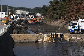
In search of bodies, the Tona Canal in Nobiru was dammed by the river, water was pumped out and debris was removed from the canal bed (Photo: May 25, 2011)
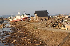
Boat stranded on the bank of the Kitakami Canal (北上 運河) in the district of Ōmagari (大曲) (Photo: May 24, 2011)
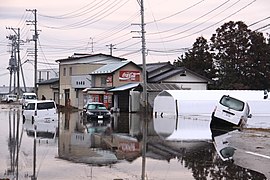
Tsunami damage in the Akai district (赤 井) (Photo: March 13, 2011)


reconstruction
At the beginning of August 2015, the city announced that it would buy the former platform of Nobiru Station from the JR East Railway Company and keep it as a disaster ruin. The tracks and signage were left in their condition and the station building was renovated. 22 meters further inland from the old one, a new Nobiru station went into operation on May 30, 2015, when the JR East's Senseki line was opened to traffic on the entire railway line. The memorial park was opened on August 1, 2016.
traffic
- Train:
- Street:
- Sanriku Highway
- National road 45
Neighboring cities and communities
Individual evidence
- ↑ a b c d e f g h i Lori Dengler, Megumi Sugimoto: Learning from Earthquakes - The Japan Tohoku Tsunami of March 11, 2011 . In: EERI Special Earthquake Report . November 2011, p. 1-15 . , Earthquake Engineering Research Institute (EERI).
- ↑ a b c d e f g h i Megumi Sugimoto: Geoethics and Risk-Communication Issues in Japan's Disaster Management System Revealed by the 2011 Tohoku Earthquake and Tsunami . In: Max Wyss, Silvia Peppoloni (Ed.): Geoethics - Ethical Challenges and Case Studies in Earth Sciences . Elsevier, Amsterdam [et al.] 2015, ISBN 978-0-12-799935-7 , chap. 26 , p. 324–334 ( work partially accessible online on Google Books [accessed August 25, 2018]).
- ↑ a b c d Katerina-Navsika Katsetsiadou, Emmanuel Andreadakis, Efthimis Lekkas: Tsunami intensity mapping: applying the integrated Tsunami Intensity Scale (ITIS2012) on Ishinomaki Bay Coast after the mega-tsunami of Tohoku, March 11, 2011 . In: Research in Geophysics . tape 5 , no. 1 , 2016, p. 5857 (7-16) , doi : 10.4081 / rg.2016.5857 . , License: Creative Commons Attribution-NonCommercial 4.0 International (CC BY-NC 4.0). Special issue on Mega Earthquakes and Tsunamis.
- ↑ a b c d e Isao Hayashi: Materializing Memories of Disasters: Individual Experiences in Conflict Concerning Disaster Remains in the Affected Regions of the Great East Japan Earthquake and Tsunami . In: Bulletin of the National Museum of Ethnology [ 国立 民族 学 博物館 研究 報告 ] . tape 41 , no. 4 , March 30, 2017, p. 337-391 , doi : 10.15021 / 00008472 .
- ↑ a b Soichiro Shimamura, Fumihiko Imamura, Ikuo Abe: Damage to the Railway System along the Coast Due to the 2011 Tohoku Earthquake Tsunami . In: Journal of Natural Disaster Science . tape 34 , no. 1 , 2012, p. 105-113 , doi : 10.2328 / jnds.34.105 .
- ↑ Massive tsunami submerges towns, washes away houses, cars ( Memento from March 13, 2011 in the Internet Archive )
- ↑ a b c 平 成 23 年 (2011 年) 東北 地方 太平洋 沖 地震 (東 日本 大 震災) に つ い て (第 157 報) ( Memento from March 18, 2018 on WebCite ) ( PDF ( Memento from March 18, 2018 on WebCite )),総 務 省 消防 庁 (Fire and Disaster Management Agency), March 7, 2018.
- ↑ Tsunami hit city aims to be reborn ( Memento from March 14, 2016 on WebCite ) (English), japantimes.co.jp ( The Japan Times ), January 1, 2013, by Maya Kaneko.
- ↑ Tsunami survivors face monstrous cleanup task ( Memento from March 14, 2016 on WebCite ) , japantimes.co.jp ( The Japan Times ), March 26, 2011, by Tim Sullivan (AP).
- ↑ Grounding, Japan Tsunami - Tsunami: Chokai Maru ( Memento of 14 March 2016 Webcite ) (English), shipwrecklog.com, posted on March 11, 2011 by "Paul Hancock" .
- ↑ Report: The Tsunami ( Memento from March 14, 2016 on WebCite ) , focus.de, March 21, 2011 (Focus Magazin, No. 12, 2011).
- ↑ After the disaster - Japan is cleaning up - but where first? ( Memento from March 14, 2016 on WebCite ) , blick.ch, March 24, 2011 (updated: January 20, 2012) (SDA).
- ↑ 「鳥 海 丸」 住宅 街 を 裂 く 東 松 島 市 ・ 加 茂 水産 高 の 4 代 目 実 習 船 ( Memento from March 14, 2016 on WebCite ) (Japanese), yamagata-np.jp (Yamagata News Online), March 24, 2011 .
- ↑ 東 日本 大 震災 図 説 集 . In: mainichi.jp. Mainichi Shimbun- sha, May 20, 2011, archived from the original on June 19, 2011 ; Retrieved June 19, 2011 (Japanese, overview of reported dead, missing and evacuated).
- ↑ 平 成 22 年 国 勢 調査 - 人口 等 基本 集 計 結果 - (岩手 県 , 宮城 県 及 び 福島 県) ( Memento from March 24, 2018 on WebCite ) (PDF, Japanese), stat.go.jp (Statistics Japan - Statistics Bureau , Ministry of Internal Affairs and communication), 2010 Census, Summary of Results for Iwate, Miyagi and Fukushima Prefectures, URL: http://www.stat.go.jp/data/kokusei/2010/index.html .
- ↑ Tadashi Nakasu, Yuichi Ono, Wiraporn Pothisiri: Why did Rikuzentakata have a high death toll in the 2011 Great East Japan Earthquake and Tsunami disaster? Finding the devastating disaster's root causes . In: International Journal of Disaster Risk Reduction . tape 27 , 2018, p. 21-36 , doi : 10.1016 / j.ijdrr.2017.08.001 . (Published online on August 15, 2017), here p. 22, table 2.
- ↑ a b 平 成 23 年 (2011 年) 東北 地方 太平洋 沖 地震 (東 日本 大 震災) に つ い て (第 153 報) ( Memento of March 10, 2016 on WebCite ) , 総 務 省 消防 庁 (Fire and Disaster Management Agency), 153. Report, March 8, 2016.
- ↑ a b c Nam Yi Yun, Masanori Hamada: Evacuation Behavior and Fatality Rate during the 2011 Tohoku-Oki Earthquake and Tsunami . In: Earthquake Spectra . tape 31 , no. 3 , August 2015, p. 1237-1265 , doi : 10.1193 / 082013EQS234M . , here table 2.
- ↑ a b Kimiaki Sato, Michio Kobayashi, Satoru Ishibashi, Shinsaku Ueda, Satoshi Suzuki: Chest injuries and the 2011 Great East Japan Earthquake . In: Respiratory Investigation . tape 51 , no. 1 , March 2013, p. 24–27 , doi : 10.1016 / j.resinv.2012.11.002 . (Published online on). License: Creative Commons Attribution-NonCommercial-NoDerivatives 4.0 International (CC BY-NC-ND 4.0).
Web links
- 10 万分 1 浸水 範 囲 概況 図 , 国土 地理 院 ( Kokudo Chiriin , Geospatial Information Authority of Japan, formerly: Geographical Survey Institute = GSI), www.gsi.go.jp: 地理 院 ホ ー ム> 防災 関 連> 平 成 23 年 (2011年) 東北 地方 太平洋 沖 地震 に 関 す る 情報 提供> 10 万分 1 浸水 範 囲 概況 図:
- The GSI published here a map with Higashimatsushima ( 浸水範囲概況図12 ) on which the 2011 flooded areas are drawn on the basis of reports of aerial photographs and satellite images from the Tōhoku tsunami, as far as was possible.
Independent cities ( shi ): Higashimatsushima | Ishinomaki | Iwanuma | Kakuda | Kesennuma | Kurihara | Natori | Ōsaki | Sendai (administrative headquarters) | Shiogama | Shiroishi | Tagajō | Tome | Tomiya
Igu-gun : Marumori | Kami-gun : Kami | Shikama | Ring- tailed lemur : Shichikashuku | Zaō | Kurokawa-gun : Ōhira | Ōsato | Taiwa | Miyagi-gun : Matsushima | Rifu | Shichigahama | Motoyoshi-gun : Minamisanriku | Oshika-gun : Onagawa | Shibata-gun : Kawasaki | Murata | Ōgawara | Shibata | Toda-gun : Misato | Wakuya | Watari-gun : Watari | Yamamoto