Miyato-jima
| Miyato-jima | ||
|---|---|---|
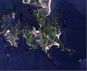
| Landsat image of Sabusawa-jima (left) and Miyato-jima (right) | ||
| Waters | Sendai Bay , Pacific Ocean | |
| Geographical location | 38 ° 20 '10 " N , 141 ° 9' 20" E | |
|
|
||
| length | 5 km | |
| width | 3.5 km | |
| surface | 7.06 km² | |
| Highest elevation | Ōtakamori 104.8 m |
|
| Residents | 1030 (2005) 146 inhabitants / km² |
|
| main place | Miyato | |
Miyato-jima ( Japanese 宮 戸 島 ) is a Japanese island in Sendai Bay .
geography
The 7.06 km² island is located in Sendai Bay, separating Ishinomaki Bay in the east from Matsushima Bay in the west. Miyato-jima itself is in turn separated in the west by the 100 m wide Wanigafuchi Canal ( 鰐 ヶ 渕 水道 , ~ -suidō ) from the island of Sabusawa-jima of the Urato Islands . Like many others in Matsushima Bay, the island has a very irregular shape with many deeply indented bays. It is believed that the islands originally formed a common land mass that was divided into today's islands by the Jōgan earthquake and tsunami in 869 .
Originally, it was connected to Suzaki-hama ( 洲 崎 浜 ) beach via a sandbar ( tombolo ) and thus a peninsula. However, in 1963 the Katsugigaura Canal ( 潜 ヶ 浦 水道 ) was dug through the sandbar , which finally separated Miyato-jima completely from the mainland. The channel also separated the northeastern cape Nihonmatsu-bana from Miyato-jima, making it an island in its own right.
Geologically, the island consists of tertiary tuff . The weather is characterized by warm winters and the island has a lush population of hemp palms .
Until 1955 the island formed the village community Miyato ( 宮 戸 村 , - mura ), was then incorporated into Naruse , which in turn was incorporated into Higashimatsushima in 2005 . At that time there were 1030 inhabitants on Miyato-jima. The main settlement area is on the northwestern bay of Satoura ( 里 浦 ). The main occupation is the cultivation of seaweed ( nori ) and mussel farming.
To the east of this is also the hill Ōtakamori ( 大 高 森 ) which, at 104.8 m, is the highest point on the island.
There are around 260 islands in and around Matsushima Bay, with the following clockwise-listed islands being Miyato-jima satellites:
Ōyatori-jima and Koyatori-jima are part of Shiogama Township , like the Urato Islands, but closer to Miyato-jima.
Individual evidence
- ↑ 島 面積 . (PDF; 136 kB) (No longer available online.) Kokudo Chiriin , October 1, 2015, archived from the original on June 15, 2016 ; Retrieved August 2, 2016 (Japanese). Info: The archive link was inserted automatically and has not yet been checked. Please check the original and archive link according to the instructions and then remove this notice.
- ↑ 浦 戸 村 の 沿革 . Shiogama Ward, October 1, 2012, accessed August 15, 2015 (Japanese).
- ↑ a b c 宮 戸 島 . In: 世界 大 百科 事 典 第 2 版 at kotobank.jp. Retrieved August 14, 2015 (Japanese).
- ↑ 宮 戸 島 (み や と じ ま) . In: 日本 の 島 へ 行 こ う . Retrieved August 14, 2015 (Japanese).
- ↑ a b official topographic map of Kokudo Chiriin

