Shiroishi (Miyagi)
| Shiroishi-shi 白石 市 |
||
|---|---|---|
|
|
||
| Geographical location in Japan | ||
| Region : | Tōhoku | |
| Prefecture : | Miyagi | |
| Coordinates : | 38 ° 0 ' N , 140 ° 37' E | |
| Basic data | ||
| Surface: | 286.47 km² | |
| Residents : | 33,380 (October 1, 2019) |
|
| Population density : | 117 inhabitants per km² | |
| Community key : | 04206-4 | |
| Symbols | ||
| Flag / coat of arms: | ||
| Tree : | Notched beech | |
| Flower : | Kerrie | |
| Bird : | Japanese Bush Warbler | |
| town hall | ||
| Address : |
Shiroishi City Hall 1 - 1 , Ote-machi Shiroishi -shi Miyagi 989-0292 |
|
| Website URL: | http://www.city.shiroishi.miyagi.jp | |
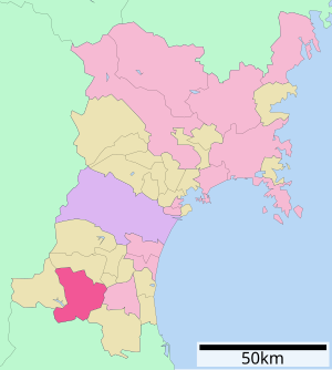
| Location of Shiroishi's in Miyagi Prefecture | ||
Shiroishi ( Japanese 白石 市 , - shi ) is a city in Miyagi Prefecture on Honshū , the main island of Japan .
geography
Shiroishi is north of Fukushima and south of Sendai . The Shiroishi River with its 69.7 km total length is the most important river in the city area.
history
- 1602 Katakura Kojūrō , a tenant of Date Masamune , got the Shiroishi Castle and the administration of the area. During his reign he developed the city's infrastructure.
- In 1954 Shiroishi merged with 10 surrounding villages.
- In 1957 the village of Obara with its hot springs was incorporated.
traffic
- Street:
- Tōhoku Highway
- National road 4 , to Tokyo or Aomori
- National road 113,457
- Train:
- JR Tōhoku Shinkansen : Shiroishi-Zaō Station
- JR Tōhoku main line
Attractions
Neighboring cities and communities
Town twinning
- 1983 Noboribetsu , Hokkaidō , Japan
- 1991 Ebina , Kanagawa , Japan
- 1994 Hurstville City , Australia
Web links
Commons : Shiroishi - collection of images, videos and audio files


