Matsushima (Miyagi)
| Matsushima-chō 松 島 町 |
||
|---|---|---|
| Geographical location in Japan | ||
|
|
||
| Region : | Tōhoku | |
| Prefecture : | Miyagi | |
| Coordinates : | 38 ° 23 ' N , 141 ° 4' E | |
| Basic data | ||
| Surface: | 54.04 km² | |
| Residents : | 13,468 (October 1, 2019) |
|
| Population density : | 249 inhabitants per km² | |
| Community key : | 04401-6 | |
| Symbols | ||
| Flag / coat of arms: | ||
| Tree : | jaw | |
| Flower : | Dendrobium moniliforme | |
| town hall | ||
| Address : |
Matsushima Town Hall 10 , Aza Machi, Takagi Matsushima -chō, Miyagi-gun Miyagi 981-0215 |
|
| Website URL: | http://www.town.matsushima.miyagi.jp/ | |
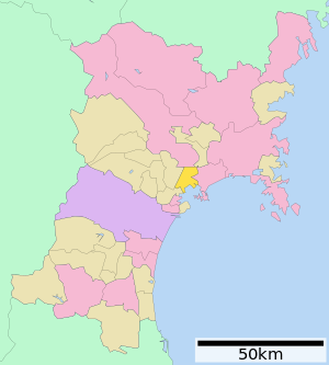
| Location of Matsushima's in Miyagi Prefecture | ||
Matsushima ( Japanese 松 島 町 , - machi , German "pine islands") is a small town in the Japanese prefecture of Miyagi .
Attractions
- Zuigan-ji ( 瑞 巌 寺 ), the temple founded in 828 and rebuilt in 1610, which belongs to the Rinzai direction of Zen, is one of the most famous in Tōhoku.
- Godaidō ( 五 大堂 ), a Buddhist prayer hall, dedicated to the "Five Enlightened Kings" ( 五大 明王 , Godai myōō ), is located on an island that can be reached directly from the shore via a bridge.
- The place is right on Matsushima Bay , the main attraction of the prefecture. It is a bay with around 260 pine-covered islands, 22 km northeast of Sendai . In addition to Amanohashidate and Miyajima , Matsushima is one of the three most beautiful landscapes in Japan , which has made its beaches and the nearby historical sites into corresponding strongholds of tourism. - Due to its particular beauty, Matsushima Bay has also found its way into classical Japanese literature: the poet Matsuo Bashō dedicates a separate chapter to Matsushima Bay in his travel diary Oku no Hosomichi . The place advertises with the Bashō attributed haiku "Matsushima ya / aa Matsushima ya / Matsushima ya".
Tōhoku earthquake
On March 11, 2011, the city was hit by the Tōhoku earthquake and the subsequent tsunami. In contrast to many other coastal towns in the Tōhoku region, however, the height of the tsunami in Matsushima remained below the height of the dike.
According to the damage report by the fire and disaster control authority, 7 people in Matsushima lost their lives as a result of the disaster. 221 residential buildings were completely destroyed and 1,785 partially.
photos
Chōmei-ana in Komone-jima (collapsed by the Tōhoku earthquake in 2011 )
traffic
- Street:
- Sanriku Highway to Sendai or Miyako
- National Road 45 to Sendai or Aomori
- National Road 346 to Sendai or Kesennuma
- Train:
- JR Tōhoku main line from Matsushima , Atago or Shinainuma to Ueno or Morioka
- JR Senseki Line from Matsushima-Kaigan , Takagimachi , Teataru or Rikuzen-Tomiyama to Sendai or Ishinomaki
Matsushima Airport is located south of the city.
Neighboring cities and communities
additional
Marion Poschmann's novel Die Kieferninseln refers to the islands in the bay of Matsushima. The city itself is the final scene of the text.
Web links
-
10 万分 1 浸水 範 囲 概況 図 , 国土 地理 院 ( Kokudo Chiriin , Geospatial Information Authority of Japan, formerly: Geographical Survey Institute = GSI), www.gsi.go.jp: 地理 院 ホ ー ム> 防災 関 連> 平 成 23 年 (2011年) 東北 地方 太平洋 沖 地震 に 関 す る 情報 提供> 10 万分 1 浸水 範 囲 概況 図
The GSI publishes two maps with Matsushima, 浸水 範 囲 概況 図 12 (PDF) and 浸水 範 囲 概況 図 13 (PDF), on which the Areas flooded by the Tōhoku tsunami 2011 are drawn on the basis of evaluations of aerial photographs and satellite images, as far as possible. - Aerial photography
Individual evidence
- ↑ 東 日本 大 震災 図 説 集 . In: mainichi.jp. Mainichi Shimbun- sha, May 20, 2011, archived from the original on June 19, 2011 ; Retrieved June 19, 2011 (Japanese, overview of reported dead, missing and evacuated).
- ↑ Anawat Suppasri, Nobuo Shuto, Fumihiko Imamura, Shunichi Koshimura, Erick Mas, Ahmet Cevdet Yalciner: Lessons Learned from the 2011 Great East Japan Tsunami: Performance of Tsunami Countermeasures, Coastal Buildings, and Tsunami Evacuation in Japan . In: Pure and Applied Geophysics . tape 170 , no. 6-8 , 2013, pp. 993-1018 , doi : 10.1007 / s00024-012-0511-7 . (Published online July 7, 2012).
- ↑ Mikio Ishiwatari, Junko Sagara: Structural Measures Against Tsunamis . In: Federica Ranghieri, Mikio Ishiwatari (Ed.): Learning from Megadisasters - Lessons from the Great East Japan Earthquake . World Bank Publications, Washington, DC 2014, ISBN 978-1-4648-0153-2 , Chapter 1, pp. 25–32 , doi : 10.1596 / 978-1-4648-0153-2 ( Google Books [accessed April 3, 2018]). , License: Creative Commons Attribution CC BY 3.0 IGO.
- ↑ 平 成 23 年 (2011 年) 東北 地方 太平洋 沖 地震 (東 日本 大 震災) に つ い て (第 157 報) ( Memento from March 18, 2018 on WebCite ) fdma.go.jp ( Memento from March 18, 2018 on WebCite ) (PDF ) 総 務 省 消防 庁 (Fire and Disaster Management Agency), 157th report, March 7, 2018.


