
Kesennuma
| Kesennuma-shi 気 仙 沼 市 |
|||
|---|---|---|---|
 |
|||
| Geographical location in Japan | |||
|
|||
| Region : | Tōhoku | ||
| Prefecture : | Miyagi | ||
| Coordinates : | 38 ° 54 ' N , 141 ° 34' E | ||
| Basic data | |||
| Surface: | 226.67 km² | ||
| Residents : | 60,840 (October 1, 2019) |
||
| Population density : | 268 inhabitants per km² | ||
| Community key : | 04205-6 | ||
| Symbols | |||
| Flag / coat of arms: |
 |
||
| Tree : | Japanese black pine | ||
| Flower : | Rhododendron kaempferi var. Kaempferi | ||
| Bird : | Japanese gull | ||
| Fish : | Real bonito | ||
| town hall | |||
| Address : |
Kesennuma City Hall 1 - 1 - 1 , Yoka-machi Kesennuma -shi Miyagi 988-8501 |
||
| Website URL: | http://www.city.kesennuma.lg.jp/ | ||
| Location of Kesennumas in Miyagi Prefecture | |||
 |
|||

Kesennuma ( Japanese 気 仙 沼 市 , -shi ) is a city in Miyagi Prefecture on Honshū , the main island of Japan .
geography

Kesennuma is north of Sendai and southeast of Morioka on the Pacific Ocean . The city is located at the innermost end of the elongated and 1 km wide Bay of Kesennuma, which is formed in this area by the Ria coast and opens in its southern part to the Pacific coast. The urban developed areas are concentrated on the west and north ends of the bay. The entrance to the Bay of Kesennuma, which has a total area of 15.4 km², is 2.6 km wide. The bay is somewhat protected from the ocean by the island of Ōshima (大 島) and the headland in the east (Karakuwa Peninsula / 唐桑 半島).
The coast's Ria geography, while offering an abundance of natural resources, also poses a disaster risk for the city. The coastal region is prone to both tsunamis and floods . Seawalls protect the land from the sea, pumps remove flood water and river dikes regulate the flow of rivers.
history
The city of Kesennuma is said to have been founded in the 14th century to collect gold mined from the interior and to ship it to Sendai , Edo (now Tokyo ) and Kyoto . In its early days, the city consisted of two areas, the inland settlement ( Furumachi ) and the inner port area ( Naiwan ), which lies at the end of a long bay in the Pacific Ocean and is protected from natural disasters such as typhoons , heavy surf and storms. The Furumachi and the Naiwan were about a kilometer apart and connected by the main road running in an east-west direction. The early settlers viewed the port area as a place of work rather than living.
In modern times, the port area previously only used as a place of work for fishing and the food industry was made culturally and developed. Shops, offices, factories, restaurants and houses were soon built over. The city flourished and the rice wine brewing industry also developed on the northern slope side (namely the Kakuboshi Brewery and the Otokomaya Brewery), which soon established headquarters and shops on Nairan Main Street.
The Naiwan port area was completely destroyed twice in 1916 and 1929 by unintentional and non-natural disaster-related fires. The population was able to rebuild the city and industry with great effort and bring it to a new bloom. After the 1929 fire, people introduced a fireproof construction by covering the wooden structure of the houses with a reinforced wall of mortar. While some simply retained the previous wooden appearance, others introduced masonry or a design similar to reinforced concrete.
In the 1970s, the city developed into one of the five largest fishing bases in Japan.
On October 1, 2009, Motoyoshi was incorporated from the Motoyoshi-gun .
Before the 2011 disaster, Kesennuma was one of the most important cities on the Sanriku Coast with 75,000 inhabitants. Their main industries included fishing , seafood processing, and shipbuilding . Before the 2011 tsunami, Kesennuma was a thriving commercial fishing port and center of Japan's shark fin trade. Due to the tsunami, the city lost its historically built-up district.
Earthquake and tsunami disasters

The Sanriku coast has been hit by several tsunamis over the past two centuries: the Meiji-Sanriku tsunami in 1896 , the Shōwa-Sanriku tsunami in 1933, and the Tōhoku tsunami in 2011 .
| Disaster event | Completely destroyed houses | Death toll | source |
|---|---|---|---|
| Meiji 1896 (earthquake and tsunami) | 486 | 1887 | |
| Shōwa 1933 (earthquake and tsunami) | 407 | 79 | |
| Tōhoku 2011 (earthquake and tsunami) | 8533 | 1325 | |
| Note: The death toll for the 2011 Tōhoku disaster is calculated from the total number of dead and missing in the 153rd FDMA damage report of March 8, 2016, minus the figures for catastrophe-related deaths determined by the Reconstruction Agency (RA). | |||
Tōhoku disaster 2011
The Tōhoku earthquake of March 11, 2011 was registered in the central part of Kesennuma with level 6 of the Japanese seismic intensity scale and reached level 5 in the Motoyoshi area in the southern part of the city.
Extent of flooding and damage
The tsunami streamed north up the bay in Kesennuma, reached the harbor as a fast-flowing rising tide and flooded harbor embankments and river fortifications. Significant damage occurred along the western bank of the Bay of Kesennuma (left, i.e. east of the Ōkawa / 大川 River) and in the northern area of the city at the inner end of the bay. About a third of the area was flooded. In the Motoyoshi district, the tsunami flooding reached a height of 19.3 m. The tsunami flooded the Naiwan, Shishiori and Minami-Kesennuma districts. The tsunami reached Naiwan at a height of 5 to 6 m and carried floating objects with it, such as steel ships and timber. Although concrete and steel buildings in Naiwan were able to withstand the tsunami, vehicles and machines suffered total losses in the salt water and wooden buildings were washed away and destroyed by the tsunami. In contrast, only a few, all of which had been recognized by the Bunka-chō as a nationally listed heritage in 2001, withstood, albeit in poor condition. While the flood heights of the tsunami measured in many places outside of Kesennuma Bay were more than 10 m, they were generally below 10 m inside Kesennuma Bay. Flood heights measured around the port of Kesennuma were 7.79 and 11.84 m. At the inner end of the bay about 500 m inland flooding heights of 7–8 m were measured.
The city of Kesennuma was badly hit by a fire that apparently had started at the oil terminal in the south of the city and spread across flotsam. The fires triggered by the earthquake and the subsequent tsunami affected large parts of the city. Damaged oil tanks exploded in the village of Shishiori, causing large fires. The massive fires in Kesennuma Bay are a typical example of tsunami-induced fires that started from destroyed oil tanks. Oil had leaked from these tsunami-destroyed oil tanks in the port of Kesennuma, causing fires that spread to other urban areas with the tsunami floods.
In Motoyoshicho-Nakajima (本 吉 町 中 島), 15 km south of the port of Kesennuma, around 300 m of coastal erosion was observed. In this area, the low-lying land extended around the mouth of the Tsuya River, which is why an extensive area was flooded here. In the eroded area, tsunami flood heights of 9.23 and 10.88 m were measured.
In the northern part of the city of Kesennuma, the flooding in conjunction with 0.74 m deep co-seismic subsidence prevented access to the coast.
Many of the large packaging companies in the area around the port have suffered damage from soil liquefaction . Dozens of boats were torn from their moorings and washed away inland or sank in the bay. Large boats were washed ashore. The many large and small fishing vessels that the tsunami swept away in the port of Kesennuma and that were stranded inland contributed to the damage to houses and other structures. Even mud , which in some places reached a thickness of around 10 cm or more, was carried out of the sea and deposited inland, which hampered the relief efforts.
10,000 people had to be evacuated to emergency shelters. The number of completely destroyed residential buildings is put at 8,483.


The 60 meter long fishing vessel Kyotoku-maru No.18 (第 18 共 徳 丸) equipped with purse seine with a total tonnage of 330 tons and a gross weight of 500 to 800 tons, which belonged to the fishing company Gisuke Gyogo from Fukushima Prefecture and is currently owned The disaster was in a port for regular inspection, was driven 750 meters from the port into the city of Kesennuma by the tsunami and was stranded in front of the already collapsed Shishiori-Karakuwa station of the JR East- Ōfunato Line at the intersection of prefecture roads 210 and 34 im Shishiori district of Nakaminato-cho. It became a symbol of the tsunami. It was too big and heavy to take away. In 2013, contrary to existing plans by the city of Kesennuma to preserve the boat as a memorial in the memorial park, a majority of the city's population voted to scrap it, which was carried out from September to the end of October 2013.
In the Kesennuma Koyo High School building in Hajikamisemukai, the tsunami reached the fourth floor, causing damage and objects. On May 11, 2015, the city of Kesennuma decided to keep the school building. Only the southern school building, on the third floor of which there is still a car carried in by the tsunami, is to be left in its condition. The school building should be open to the public to enter, to illustrate the height of the tsunami to future generations. On the same property in Hajikamisemukai, a newly built tourist facility is said to show documents about the Tōhoku earthquake and tsunami.

The Tsuyagawa Bridge, built in 1974 and over which the Kesennuma Line of the JR East ran, was washed over by the tsunami at a speed of 6.7 m / s and a flood height at the time of the highest speed of around 13 meters. The first inland wave of the tsunami severely damaged the bridge. The tsunami damage caused the bridge to collapse.
At the time of the earthquake, a two-car train on the Kesennuma Line operated by JR East , destined for Kogota, was traveling between Matsuiwa and Saichi stations and made an emergency stop. The train driver then received the tsunami alarm, let the passengers get off and began the successful evacuation of passengers and train personnel to the junior high school located about 1 km inland. The train was lifted off the track by the tsunami and torn away around 60 m.
Victim
The fire and disaster control authority (FDMA) reported 930 dead and 604 missing in its damage report of May 19. The number of deaths increased to 1,217 in the later damage record, while 215 people were still missing.
Measured against the total population of Kesennuma, which was given as 73,489 in the 2010 census, the casualty rate from the 2011 disaster was 1.9%, if all dead and missing persons registered in the 157th FDMA damage report of March 7, 2018 are taken into account or 1.80% if the victims registered in the 153rd FDMA damage report of March 8, 2016 (1,214 dead and 220 missing) minus the catastrophe-related deaths reported by the Reconstruction Agency (RA) are taken into account, resulting in a Figure of 1,325 dead and missing results. With the same database, but based solely on the floodplain area of the tsunami in Kesennuma, which covered an area of 18 km 2 , the casualty rate was 3.29%, according to other calculations 3.5%. 40,331 people and thus 55% of the total population of the city of Kesennuma (assuming 73,494 inhabitants in 2010) had their residence in the area flooded by the tsunami on March 11, 2011.
Despite the high absolute death toll in Kesennuma, the death rate of the population in the flooded area remained relatively low.
| Area in Kesennuma | Fatalities | Residents | Tsunami | Distance to the next evacuation site [m] | ||
|---|---|---|---|---|---|---|
| Rate [%] | number | Max. Flooding height [m] | Arrival time [min.] | |||
| Matsuzaki | 1.47 | 107 | 7,258 | 5.24 | 55 | 505 |
| Hajikami | 6.90 | 95 | 1,377 | 17.63 | 40 | 647 |
| Motoyoshi | 0.80 | 87 | 10,855 | 18.36 | 39 | 180 |
| Karakuwa | 1.06 | 79 | 7,420 | 15.39 | 38 | 381 |
| Nainowaki | 5.91 | 71 | 1,201 | 5.20 | 55 | 585 |
| Saiwaicho | 4.84 | 42 | 867 | 4.20 | 55 | 217 |
| Akaiwa | 0.69 | 30th | 4,371 | 0.66 | 55 | 564 |
| Nango | 1.73 | 22nd | 1,271 | 4.11 | 55 | 704 |
| Nakaminato | 3.58 | 21st | 586 | 5.57 | 55 | 721 |
| Nagaiso | 0.84 | 21st | 2,498 | 1.24 | 41 | 242 |
| Higashiminato | 5.51 | 21st | 381 | 5.37 | 55 | 478 |
| Kawaguchi | 5.19 | 20th | 385 | 7.12 | 55 | 1,193 |
| Saichi | 2.37 | 19th | 802 | 3.99 | 42 | 778 |
| Iwatsuki | 0.57 | 18th | 3.159 | 0.22 | 44 | 730 |
| Shinhama | 3.12 | 17th | 545 | 5.64 | 55 | 910 |
| Nishikicho | 3.74 | 15th | 401 | 5.65 | 55 | 849 |
| Hammamachi | 10.48 | 13 | 124 | 7.05 | 55 | 1,131 |
| Sakanamachi | 3.00 | 12 | 400 | 5.27 | 55 | 715 |
| Higashihachimanmae | 1.24 | 10 | 808 | 1.77 | 55 | 436 |
| Oura | 2.68 | 8th | 299 | 5.13 | 55 | 545 |
| Nakasai | 0.66 | 6th | 914 | 1.63 | 55 | 404 |
| Sakae-cho | 0.45 | 7th | 1,555 | 4.21 | 55 | 407 |
| Tanakamae | 2.39 | 6th | 251 | 4.55 | 55 | 1,113 |
| Minato | 4.85 | 5 | 103 | 4.68 | 55 | 673 |
| Minami-Kesennuma | 0.83 | 5 | 603 | 4.67 | 55 | 121 |
| Ota | 0.91 | 4th | 439 | 3.90 | 55 | 628 |
| Ninohama | 2.41 | 4th | 166 | 5.67 | 55 | 364 |
| Hongo | 0.68 | 4th | 591 | 1.94 | 55 | 462 |
| Uranohama | 1.43 | 3 | 210 | 7.31 | 44 | 618 |
| Asane | 0.39 | 2 | 511 | 2.90 | 41 | 274 |
| Taya | 0.20 | 1 | 502 | 1.08 | 55 | 279 |
| Yoka | 0.52 | 1 | 193 | 2.35 | 55 | 285 |
| Namiita | 8.48 | 14th | 165 | 5.11 | 55 | 843 |
| Source: Total population according to Statistics Bureau (統計局) and Director-General for Policy Planning (政策 統 括 官), 2010 census; Fatalities according to fire and disaster management agency (消防 庁 = Fire and Disaster Management Agency, FDMA); Maximum flood height and arrival time of the tsunami according to The 2011 Tohoku Earthquake and Tsunami Joint Survey Group ; Distance to the nearest evacuation site from the place of residence according to the evacuation site data from the Cabinet Secretariat Civil Protection Portal Site ( http://www.kokuminhogo.go.jp/en/pc-index_e.html ) of the Cabinet Secretariat (内閣 官 房) and the aerial photographs and maps from Geospatial Information Authority of Japan (GSI) from the Tsunami Damage Mapping Team, Association of Japanese Geographers. | ||||||
evacuation
In Kesennuma, 12 buildings were designated for vertical evacuation by the city administration in 1982 and three more were added later. On March 11, 2011, these buildings served as refuge for 2,326 people. These included an office building located directly on the coastline at the inner harbor (not used for evacuation, no rescued persons), the Yoyoi food factory (400 rescued people, flood height about 8 m), a shoe store (5 rescued), a welfare center ( 80 people rescued on the upper floors, flood height about 8 m), the tourist pier and fish market (1,000 people rescued on the large open vehicle parking deck above the fish harbor almost on the edge of the harbor, the open steel frame enabled the tsunami to flow through the first floor), the building of the prefectural offices built in 2004 (200 rescued, flood height approx. 8 m), the office of the national government adjacent to the building mentioned above (120 rescued, the two lower floors were flooded), the Central Community Center (気 仙 沼 中央 公民 館, 450 rescued, those from Buildings nearby were evacuated) and the office of the daily newspaper Kahoku (71 rescued, flooding at least up to the ceiling of the first floor). With the exception of the parking deck above the fish market, whose functionality for vertical evacuation had been taken into account in the design, all of these buildings complied with the guidelines adopted in 2005 for evacuation buildings. Some of these evacuation buildings were almost flooded by the tsunami. Since the tide was low when the tsunami reached Kesennuma, it is assumed that these vertical evacuation buildings would have been flooded with a tide 1 m higher at the time of the tsunami arrival. The fire brigade concluded that buildings designated for vertical evacuation would have to have at least 5 storeys in future.
Some evacuation centers narrowly escaped the severe fires in Kesennuma, where many buildings caught fire after 51,000 liters of oil leaked from damaged oil tanks.
The evacuation in Kesennuma (as well as in Natori ) was apparently impaired by the fact that a major tsunami warning was issued during the earthquake in Chile in 2010 , which then resulted in tsunami heights of 0.5-0.6 m in Kesennuma and 0, 5 m in Natori proved to be wrong. This may have led to the population underestimating the danger and reacted negligently on March 11, 2011, when waves corresponding to a Great Tsunami warning actually reached their city.
- Gallery: Devastation in Kesennuma after the earthquake and tsunami of March 11, 2011:

Aerial view of the Kawahara fishing port (March 13, 2011)

Large fishing boats have washed up in the city (Photo: April 13, 2011)
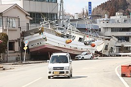
Beached boat in front of a destroyed house (March 23, 2011)
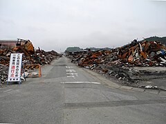
Debris in a fire-stricken area (Photo: June 12, 2011)


.jpg)

reconstruction
Half a year after the disaster, the city formed a Kesennuma Disaster Reconstruction Council made up of members of the town planning council and experts from Kesennuma who had made preparations for a reconstruction plan. At the same time, a Residents Committee for Reconstruction was established to take input from the population and incorporate it into the reconstruction plan.
Even two years after the day of the 2011 tsunami, the reconstruction and development of the administrative and economic conditions in Kesennuma were still future tasks. In 2014, various structures such as the new pier for deep sea fishing were completed. The recovery of the city and the port proceeded slowly. Most of the residents of single family houses had rebuilt their homes on nearby and higher land or registered for public condominiums. The low-lying areas in the city center were redeveloped and raised above all for industrial and commercial use or as a location for parks. The reconstruction far from the city center was delayed because on the one hand resources and capacities were limited and on the other hand there was no consensus on reconstruction between the citizens and the city.
Since only a small number of the survivors on the coast wanted to resettle in their district, the city designated around 44.5 hectares at the mouth of the Omose River as a “disaster risk area”. The river was defined as the boundary between a northern area designated for use as lowland and a southern area designated as a disaster area. Even four years after the disaster, there were no organized urban planning activities in this area, in which the population showed little interest in settlement. The Matsuiwa side of the Omose River is a low-lying area that was primarily residential prior to the 2011 disaster. It was badly damaged by the tsunami in 2011 and is also frequently inundated by rains from inland, which is why ditches, pumping stations and flood gates were used to prevent inland flooding before the disaster. While industrial areas were mainly located on the Omose side of the district prior to the 2011 disaster, the city's rebuilding plan played with the intention of locating industrial areas on the Matsuiwa side without developing a specific strategy for attracting industry.
Sea walls and dykes were built in the coastal area and on the Omose River with the aim of preventing damage in the event of a Category 1 tsunami. The dikes on the Omose were built up to 600 m upstream of the mouth. The seawall was built at a height of around 2 m above sea level, but it is planned to increase it to a height of between 4.0 and 7.2 m with a foundation width of 20 to 30 m. As of 2017, there was construction progress in a wide range of infrastructure such as seawalls, prefecture roads, Sanriku roads and Bus Rapid Transit (BRT), for which the foundations were raised.
Attractions
A special feature of Kesennuma, close to the city center, is a high diversity of historical and cultural sites and landscapes, which include the natural landscapes of the island of Ōshima, the ecosystems of the fishing port, the estuary and the upstream sections of the Omose River, and industries such as the fishing industry include the coast, agriculture along the river, and further inland forestry.
- Enunkan (the historic house is used by the Agency for Cultural Affairs (ACA) as a training facility for staff to learn more about Japanese gardens )
- Hachinan jinja (shrine)
- Ozaki jinja (the shrine is the site of a memorial for the survival of 30 people in the tsunami)
traffic
- Train:
- Street:
- National roads 45, 284
Neighboring cities and communities
- Miyagi Prefecture
- Iwate Prefecture
Web links
- 10 万分 1 浸水 範 囲 概況 図 , 国土 地理 院 ( Kokudo Chiriin , Geospatial Information Authority of Japan, formerly: Geographical Survey Institute = GSI), www.gsi.go.jp: 地理 院 ホ ー ム> 防災 関 連> 平 成 23 年 (2011年) 東北 地方 太平洋 沖 地震 に 関 す る 情報 提供> 10 万分 1 浸水 範 囲 概況 図:
- The GSI published here a map with Kesennuma ( 浸水範囲概況図9 ) on which the 2011 flooded areas are drawn on the basis of reports of aerial photographs and satellite images from the Tōhoku tsunami, as far as was possible.
Individual evidence
- ↑ a b c Lori Dengler, Megumi Sugimoto: Learning from Earthquakes - The Japan Tohoku Tsunami of March 11, 2011 . In: EERI Special Earthquake Report . November 2011, p. 1-15 . , Earthquake Engineering Research Institute (EERI).
- ↑ a b c d e f Takahito Mikami, Tomoya Shibayama, Miguel Esteban, Ryo Matsumaru: Field survey of the 2011 Tohoku earthquake and tsunami in Miyagi and Fukushima prefectures . In: Coastal Engineering Journal . tape 54 , no. 1 , 2012, p. 1250011-1-1250011-26 , doi : 10.1142 / S0578563412500118 . (Published March 29, 2012).
- ↑ a b c d e f g h i j Stuart Fraser, Alison Raby, Antonios Pomonis, Katsuichiro Goda, Siau Chen Chian, Joshua Macabuag, Mark Offord, Keiko Saito, Peter Sammonds: Tsunami damage to coastal defenses and buildings in the March 11th 2011 Mw9.0 Great East Japan earthquake and tsunami . In: Bulletin of Earthquake Engineering . tape 11 , 2013, p. 205-239 , doi : 10.1007 / s10518-012-9348-9 . (Published online March 27, 2012).
- ↑ a b c d e f g h i j k l m n o p q Wanglin Yan, Rob Roggema, Luke Middleton: Planning and Design in Kesennuma: Remember, Reconnect, Reform . In: Rob Roggema, Wanglin Yan (Eds.): Tsunami and Fukushima Disaster: Design for Reconstruction . Springer International Publishing AG, Cham 2017, ISBN 978-3-319-56740-2 , Chapter 7, pp. 95–111 , doi : 10.1007 / 978-3-319-56742-6_7 ( in Roggema & Yan partly accessible online on Google Books ). (Chapter published online for the first time on May 19, 2017)
- ↑ a b c d e f g h Hideo Izumida: Challenge to Restore the Heritage Buildings Damaged by the 2011 Tsunami Attacks, Kesennuma, Japan . In: Journal of Civil Engineering and Architecture . tape 9 , 2015, p. 999-1011 , doi : 10.17265 / 1934-7359 / 2015.08.012 .
- ↑ a b c d e f Tadashi Nakasu, Yuichi Ono, Wiraporn Pothisiri: Why did Rikuzentakata have a high death toll in the 2011 Great East Japan Earthquake and Tsunami disaster? Finding the devastating disaster's root causes . In: International Journal of Disaster Risk Reduction . tape 27 , 2018, p. 21-36 , doi : 10.1016 / j.ijdrr.2017.08.001 . (Published online August 15, 2017). With reference to: Tadashi Nakasu, Yuichi Ono, Wiraporn Pothisiri: Forensic investigation of the 2011 Great East Japan Earthquake and Tsunami disaster: a case study of Rikuzentakata , Disaster Prevention and Management, 26 (3) (2017), pp. 298-313 , doi: 10.1108 / DPM-10-2016-0213 .
- ↑ a b Number of dead, missing rises to 1,400. (No longer available online.) In: Yomiuri Shimbun. March 13, 2011, archived from the original on October 24, 2016 ; accessed on August 13, 2016 . Info: The archive link was inserted automatically and has not yet been checked. Please check the original and archive link according to the instructions and then remove this notice.
- ↑ Akihiko Hokugo: Mechanism of Tsunami Fires after the Great East Japan Earthquake 2011 and Evacuation from the Tsunami Fires . In: Procedia Engineering . tape 62 , 2013, p. 140–153 , doi : 10.1016 / j.proeng.2013.08.051 . License: Attribution-NonCommercial-NoDerivs 3.0 Unported (CC BY-NC-ND 3.0).
- ↑ Akihiko Hokugo, Tomoaki Nishino, Takuya Inada: Damage and Effects Caused by Tsunami Fires: Fire Spread, Fire Fighting and Evacuation . In: Fire Science and Technology . tape 30 , no. 4 , 2011, p. 117-137 , doi : 10.3210 / fst.30.117 . Also in: Proceedings of the International Symposium on Engineering Lessons Learned from the 2011 Great East Japan Earthquake, March 1-4, 2012, Tokyo, Japan; Pp. 43-62.
- ↑ Hironari Akiyama, Takeharu Ishibashi: Kesennuma described as 'hellish sight'. (No longer available online.) In: Yomiuri Shimbun. March 13, 2011, archived from the original on December 9, 2012 ; accessed on August 13, 2016 .
- ↑ a b 平 成 23 年 (2011 年) 東北 地方 太平洋 沖 地震 (東 日本 大 震災) に つ い て (第 157 報) ( Memento of March 18, 2018 on WebCite ) ( PDF ( Memento of March 18, 2018 on WebCite )), 総 務省 消防 庁 (Fire and Disaster Management Agency), March 7, 2018.
- ↑ a b Anawat Suppasri: The 2011 Great East Japan Tsunami: Background, Characteristics, Damage and Reconstruction . In: Dinil Pushpalal, Jakob Rhyner, Vilma Hossini (eds.): The Great Eastern Japan Earthquake 11 March 2011: Lessons Learned And Research Questions - Conference Proceedings (11 March 2013, UN Campus, Bonn) . 2013, ISBN 978-3-944535-20-3 , ISSN 2075-0498 , pp. 27-34 .
- ↑ a b c Isao Hayashi: Materializing Memories of Disasters: Individual Experiences in Conflict Concerning Disaster Remains in the Affected Regions of the Great East Japan Earthquake and Tsunami . In: Bulletin of the National Museum of Ethnology [ 国立 民族 学 博物館 研究 報告 ] . tape 41 , no. 4 , March 30, 2017, p. 337-391 , doi : 10.15021 / 00008472 .
- ↑ Japanese town to scrap marooned 'tsunami boat' ( Memento from May 1, 2018 on WebCite ) , bbc.com, August 13, 2013.
- ↑ 【3.11】 第 18 共 徳 丸 の 解体 始 ま る 震災 遺 構 を 断 念 、 ス ク ラ ッ プ に ( Memento from May 1, 2018 on WebCite ) , huffingtonpost.jp, September 9, 2013 (Update: March 9, 2017).
- ↑ a b Hamed Salem, Suzan Mohssen, Yuto Nishikiori, Akira Hosoda: Numerical Collapse Analysis of Tsuyagawa Bridge Damaged by Tohoku Tsunami . In: Journal of Performance of Constructed Facilities . June 2016, p. 04016065-1-04016065-12 , doi : 10.1061 / (ASCE) CF.1943-5509.0000925 .
- ↑ Soichiro Shimamura, Fumihiko Imamura, Ikuo Abe: Damage to the Railway System along the Coast Due to the 2011 Tohoku Earthquake Tsunami . In: Journal of Natural Disaster Science . tape 34 , no. 1 , 2012, p. 105-113 , doi : 10.2328 / jnds.34.105 .
- ↑ 平 成 23 年 (2011 年) 東北 地方 太平洋 沖 地震 (第 124 報) ( Memento from March 25, 2018 on WebCite ) ( PDF ( Memento from March 25, 2018 on WebCite )), 総 務 省 消防 庁 (Fire and Disaster Management Agency), 124th report, May 19, 2011.
- ↑ 東 日本 大 震災 図 説 集 . (No longer available online.) In: mainichi.jp. Mainichi Shimbun- sha, May 20, 2011, archived from the original on June 19, 2011 ; Retrieved June 19, 2011 (Japanese, overview of reported dead, missing and evacuated).
-
↑ 平 成 23 年 (2011 年) 東北 地方 太平洋 沖 地震 (第 158 報) ( Memento from October 3, 2018 on WebCite )
ホ ー ム> 東北 地方 太平洋 沖 地震 (東 日本 大 震災) 被害 報> 【過去】 被害 報> 平 成 23年 (2011 年) 東北 地方 太平洋 沖 地震 被害 報 157 報 ~ (1 月 ~ 12 月) ( Memento from October 3, 2018 on WebCite ) , 総 務 省 消防 庁 (Fire and Disaster Management Agency), 158th Damage Report, 7 September 2018. - ↑ 平 成 22 年 国 勢 調査 - 人口 等 基本 集 計 結果 - (岩手 県 , 宮城 県 及 び 福島 県) ( Memento from March 24, 2018 on WebCite ) (PDF, Japanese), stat.go.jp (Statistics Japan - Statistics Bureau , Ministry of Internal Affairs and communication), 2010 Census, Summary of Results for Iwate, Miyagi and Fukushima Prefectures, URL: http://www.stat.go.jp/data/kokusei/2010/index.html .
- ↑ Tadashi Nakasu, Yuichi Ono, Wiraporn Pothisiri: Why did Rikuzentakata have a high death toll in the 2011 Great East Japan Earthquake and Tsunami disaster? Finding the devastating disaster's root causes . In: International Journal of Disaster Risk Reduction . tape 27 , 2018, p. 21-36 , doi : 10.1016 / j.ijdrr.2017.08.001 . (Published online on August 15, 2017), here p. 22, table 2.
- ↑ 平 成 23 年 (2011 年) 東北 地方 太平洋 沖 地震 (東 日本 大 震災) に つ い て (第 153 報) ( Memento of March 10, 2016 on WebCite ) , 総 務 省 消防 庁 (Fire and Disaster Management Agency), 153rd report, March 8, 2016.
- ^ S. Fraser, GS Leonard, I. Matsuo, H. Murakami: Tsunami Evacuation: Lessons from the Great East Japan Earthquake and Tsunami of March 11th 2011 . In: GNS Science Report 2012/17 . Institute of Geological and Nuclear Sciences Limited, 2012, ISBN 978-0-478-19897-3 , ISSN 1177-2425 , 2.0, pp. I-VIII + 1–81 ( massey.ac.nz [PDF; accessed on June 29, 2018]). ; here: p. 3.
- ↑ Nam Yi Yun, Masanori Hamada: Evacuation Behavior and Fatality Rate during the 2011 Tohoku-Oki Earthquake and Tsunami . In: Earthquake Spectra . tape 31 , no. 3 , August 2015, p. 1237-1265 , doi : 10.1193 / 082013EQS234M . , here table 2.
- ^ A b S. Fraser, GS Leonard, I. Matsuo, H. Murakami: Tsunami Evacuation: Lessons from the Great East Japan Earthquake and Tsunami of March 11th 2011 . In: GNS Science Report 2012/17 . Institute of Geological and Nuclear Sciences Limited, 2012, ISBN 978-0-478-19897-3 , ISSN 1177-2425 , pp. I-VIII + 1–81 ( massey.ac.nz [PDF; accessed on June 29, 2018]). ; here: pp. 41–45.
- ^ S. Fraser, GS Leonard, I. Matsuo, H. Murakami: Tsunami Evacuation: Lessons from the Great East Japan Earthquake and Tsunami of March 11th 2011 . In: GNS Science Report 2012/17 . Institute of Geological and Nuclear Sciences Limited, 2012, ISBN 978-0-478-19897-3 , ISSN 1177-2425 , 2.0, pp. I-VIII + 1–81 ( massey.ac.nz [PDF; accessed on June 29, 2018]). ; here: p. 28.
- ^ New beginning with obstacles in FAZ of March 9, 2013, page 13
Remarks
- ↑ According to the specifications for tsunami warnings and advisories published by the JMA in 2006, a large tsunami is indicated from an expected tsunami height of three meters for which a message of the category Tsunami Warning: Major tsunami (given here in English) is issued, which contains the shows the predicted tsunami height specifically for each region, namely by means of the five height values 3m, 4m, 6m, 8m or ≥10m. With an expected tsunami height of one or two meters, a tsunami is indicated for which a message of the category Tsunami Warning: Tsunami is issued, which also shows the predicted tsunami height specifically for each region, namely by means of the two height values 1m or 2m. With an expected tsunami height of around half a meter, a tsunami is indicated for which a message of the category Tsunami Advisory with the predicted tsunami height of 0.5 m is issued. Source: S. Fraser, GS Leonard, I. Matsuo, H. Murakami: Tsunami Evacuation: Lessons from the Great East Japan Earthquake and Tsunami of March 11th 2011 . In: GNS Science Report 2012/17 . Institute of Geological and Nuclear Sciences Limited, 2012, ISBN 978-0-478-19897-3 , ISSN 1177-2425 , 2.0, pp. I-VIII + 1–81 ( massey.ac.nz [PDF; accessed on June 29, 2018]). ; here: p. 8.
Independent cities ( shi ): Higashimatsushima | Ishinomaki | Iwanuma | Kakuda | Kesennuma | Kurihara | Natori | Ōsaki | Sendai (administrative headquarters) | Shiogama | Shiroishi | Tagajō | Tome | Tomiya
Igu-gun : Marumori | Kami-gun : Kami | Shikama | Ring- tailed lemur : Shichikashuku | Zaō | Kurokawa-gun : Ōhira | Ōsato | Taiwa | Miyagi-gun : Matsushima | Rifu | Shichigahama | Motoyoshi-gun : Minamisanriku | Oshika-gun : Onagawa | Shibata-gun : Kawasaki | Murata | Ōgawara | Shibata | Toda-gun : Misato | Wakuya | Watari-gun : Watari | Yamamoto