Abukuma (river)
| Abukuma | ||
|
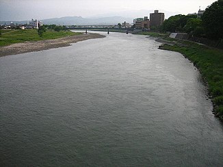
View of the river |
||
| Data | ||
| location | Japan | |
| River system | Abukuma | |
| source | Mount Asahi | |
| muzzle |
Pacific Ocean Coordinates: 38 ° 2 ′ 56 " N , 140 ° 55 ′ 17" E 38 ° 2 ′ 56 " N , 140 ° 55 ′ 17" E
|
|
| length | 239 km | |
| Catchment area | 5390 km² | |
| Big cities | Kōriyama , Fukushima | |
| Medium-sized cities | Shirakawa , Sukagawa , Nihonmatsu , Kakuda , Iwanuma | |
|
Lower Abukuma near Kakuda , April 2005 |
||
The Abukuma ( Jap. 阿武隈川 , Abukuma-gawa ) is the second longest river in the region Tohoku in Japan . It is 239 km long and has a catchment area of 5390 km².
The source of the river is on Mount Asahi ( 旭 岳 , Asahi-dake ). It then runs eastward to Shirakawa , from there northward.
This valley is the Nakadōri ( 中 通 り , "middle road") called part of Fukushima Prefecture . Many small and medium-sized towns have developed in the valley, e.g. B. Shirakawa , Sukagawa , Kōriyama , Nihonmatsu and Fukushima .
After crossing the vast Abukuma Highlands , the river continues through Miyagi Prefecture . Kakuda and Iwanuma are riverside towns. The confluence with the Pacific lies between Iwanuma and Watari .
The catchment area of Abukuma is the largest river system that the radioactive fallout of the Fukushima nuclear disaster is concerned. As a result of the nuclear disaster, increased concentrations of cesium were found in the Abukuma and its estuary in the summer of 2013 .
Individual evidence
- ↑ Yosuke Yamashiki, Yuichi Onda, Hugh G. Smith, William H. Blake, Taeko Wakahara, Yasuhito Igarashi, Yuki Matsuura, Kazuya Yoshimura: Initial flux of sediment-associated radiocesium to the ocean from the largest river impacted by Fukushima Daiichi Nuclear Power Plant . In: Scientific Reports . tape 4 , no. 3714 , 2014, p. 1-7 , doi : 10.1038 / srep03714 . (Published online January 16, 2014).
- ↑ Report in the Japantimes . (English).

