Yamagata (Yamagata)
| Yamagata-shi 山形 市 |
||
|---|---|---|
| Geographical location in Japan | ||
|
|
||
| Region : | Tōhoku | |
| Prefecture : | Yamagata | |
| Coordinates : | 38 ° 15 ' N , 140 ° 20' E | |
| Basic data | ||
| Surface: | 381.34 km² | |
| Residents : | 249,327 (October 1, 2019) |
|
| Population density : | 654 inhabitants per km² | |
| Community key : | 06201-4 | |
| Symbols | ||
| Flag / coat of arms: | ||
| Tree : | Japanese mountain ash | |
| Flower : | Safflower | |
| town hall | ||
| Address : |
Yamagata City Hall 2 - 3 - 25 , Hatagomachi Yamagata -shi Yamagata 990-8540 |
|
| Website URL: | http://www.city.yamagata-yamagata.lg.jp/ | |
| Location of Yamagatas in Yamagata Prefecture | ||
Yamagata ( Japanese 山形 市 , - shi ) is a city and the administrative seat of the Japanese prefecture Yamagata . Since April 1, 2019, the city of Yamagata has been a "core city" with expanded self-government.
geography
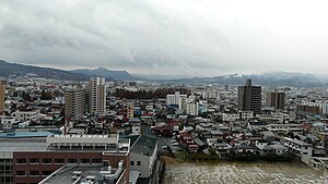
Yamagata is located in a wide basin that heats up quickly in spring and summer and is often foggy and humid. In the east, in Miyagi Prefecture on the Pacific coast, it is rather clearer and milder. In winter, however, it often snows in the basin, while the Pacific coast remains clear and snow-free.
The Mogami flows through the city from south to north. The Ōu Mountains form the eastern city limits today.
Neighboring cities and communities
- Yamagata Prefecture
- Miyagi Prefecture
history
Yamagata is an old castle town that was expanded by the Mogami before 1600. In the Edo period it was the principal seat of the Yamagata-han ( principality / daimyat / grand fief of Yamagata). After several families, a branch of the Mizuno last resided there with a nominal income of 50,000 koku , which was provided at the end of the Edo period through territories in the counties of Murayama, Sakai and Azai. The complex as a castle town with its right-angled street system shapes the cityscape to this day.
In the Meiji Restoration , the Han evolved over several intermediate stations into the eponymous Ken (prefecture), which was extended to practically the entire province of Uzen (+ a district of Ugo ) through the prefectural fusions of the Meiji period . The city of Yamagata, until then part of Murayama County or from 1878 South Murayama of Uzen / Yamagata, became one of the first independent cities in Japan on April 1, 1889 as Yamagata-shi.
Due to incorporations, especially in the 1950s, the city expanded to include considerable parts of the earlier districts of East and South Murayama.
traffic
- Streets:
- Tōhoku-Chūō Highway : Yamagata-chūō and Yamagata-Kaminoyama exit
- Yamagata Highway : Yamagata-Zaō, Yamagata-kita and Sekizawa exits
- National road 13
- National road 48
- National roads 112, 286, 348 and 458
- Railway ( JR East ):
- Yamagata Shinkansen : Yamagata Station
- Ōu main line : Zaō – Yamagata – Kita-Yamagata – Uzen-Chitose – Minami-Dewa – Urushiyama stations
- Senzan Line : Omoshiroyama-Kōgen-Yamadera-Takase-Tateyama-Uzen-Chitose-Kita-Yamagata-Yamagata stations
- Aterazawa Line : Yamagata – Kita-Yamagata – Higashikanai stations
Sights and festivals
An autumn tradition is imoni-kai ( 芋 煮 会 , sweet potato cooking party ). Taro potatoes, thinly sliced meat and vegetables are heated in pots at picnic areas. Popular picnic spots are the Mamigasaki river banks . Once a year the city administration donates a giant Imoni pot.
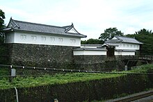
In the center of the city west of the train station is the Kajō Kōen ( 霞 城 公園 ), on the ground of the castle Yamagata of the feudal ruler Mogami Yoshiaki. While much of the park is made up of sports facilities and public buildings, the rebuilt walls, main east gate, and moat are impressive. The park is planted with cherry trees. There is a natural and social museum in the park. Not far from the park is the Yamagata Museum of Art with Japanese and European art.
The Hanagasa Festival ( 花 笠 祭 りhanagasa matsuri ), which is held annually in August, is one of the largest festivals in Tōhoku.
The Yamagata International Documentary Film Festival is held every two years .
The famous Ryūshaku-ji (Yama-dera) temple is located within the city, a 15-minute train ride from the center.
Close to the city is the Zaō winter sports area , famous for the frost in the trees.
education
The city is home to the Kojirakawa and Iida campuses of Yamagata University . The Kojirakawa Campus is home to the Faculty of Literature and Social Sciences, the Faculty of Science, and the Faculty of Education, Art, and Science. The Faculty of Medicine with the nursing school and the university hospital are located on the Iida campus.
Sports
Yamagata is the home of the Montedio Yamagata football club from the J. League , whose games are played in the Yamagata PGA Park .
Twin cities
-
 Kitzbühel , since 1963
 -
 Swan Hill , since 1980
 -
 Jilin , since 1983
 -
 Ulan-Ude , since 1991
 -
 Boulder, Colorado , since 1994
 -
 Khorramabad , since 2009
sons and daughters of the town
- Shūga Arai , football player (* 1999)
- Kenjirō Azuma , sculptor (1926-2016)
- Yuta Kamiya , soccer player (born 1997)
- Yoshitaka Kuroda , racing car driver (* 1987)
- Kiyoyuki Okuyama , designer (* 1959)
- Shōzō Sasahara , wrestler (* 1929)
- Miyuki Takahashi , volleyball player (* 1978)
- Shugyō Takahashi , haiku poet (* 1930)
- Eriko Watanabe , actress, theater director and playwright (* 1955)
Web links
Individual evidence
- ↑ National Museum of Japanese History : 旧 高 旧 領取 調帳 デ ー タ ベ ー ス (database of feudal possessions and income from the Meiji Restoration; based on the series of publications of the same name (Kimura Motoi: 旧 高 旧 領取 調帳 , 6 vols., Kondō Shuppansha 1969-79)), Search mask , entries for the Yamagata-han / the first Yamagata-ken at that time
- ^ Faculty of Literature and Social Sciences
- ↑ http://www-sci.yamagata-u.ac.jp/e_index.html
- ↑ http://www.e.yamagata-u.ac.jp/english.html
- ↑ http://www.id.yamagata-u.ac.jp/eng.html


