
Ōtsuchi (Iwate)
| Ōtsuchi-chō 大 槌 町 |
|||
|---|---|---|---|
|
|||
| Geographical location in Japan | |||
| Region : | Tōhoku | ||
| Prefecture : | Iwate | ||
| Coordinates : | 39 ° 22 ' N , 141 ° 54' E | ||
| Basic data | |||
| Surface: | 200.59 km² | ||
| Residents : | 11,046 (October 1, 2019) |
||
| Population density : | 55 inhabitants per km² | ||
| Community key : | 03461-4 | ||
| Symbols | |||
| Flag / coat of arms: |
 |
||
| Tree : | Japanese zelkove | ||
| Flower : | Shinzan azalea | ||
| Bird : | Common gull | ||
| Fish : | Ketal salmon | ||
| town hall | |||
| Address : |
Ōtsuchi Town Hall 1 - 1 , Shinchō Ōtsuchi -chō, Kamihei-gun Iwate 028-1192 |
||
| Website URL: | www.town.otsuchi.iwate.jp | ||
| Location of Ōtsuchi in Iwate Prefecture | |||
 |
|||

Ōtsuchi ( Japanese 大 槌 町 , - chō ) is a Japanese town in Kamihei County in Iwate Prefecture .
geography


The community is located on the Pacific Sanriku Coast , 50 km north of Rikuzentakata. The geometry of the Ōtsuchi area, with its steep and narrow bays, is typical of the Ria coast.
The city of Ōtsuchi is located in the alluvial alluvial cone formed by the two rivers it lies between - the Ōtsuchi in the north and the Kozuchi in the south. The Oyashio - ocean current that from the Bering Sea southward flowing into the area from Otsuchi has all year by turn affect its Klimat, the summers are cool and winters relatively moderate.
The southern part with the town center is located on the north and northwest shores of Ōtsuchi Bay ( 大 槌 湾 , Ōtsuchi-wan ), an elongated, mountain-lined bay between the Hakozaki Peninsula ( 箱 崎 半島 , Hakozaki-hantō ), the neighboring Kamaishi in the south, with the Mihako Cape ( 御 箱 埼 , Mihako-zaki ) as the end, as well as the Kirikiri Peninsula ( 吉里吉 里 半島 , Kirikiri-hantō ) in the north with the offshore island of Noshima ( 野 島 ), whose Cape Samehana ( 鮫 鼻 , dt . "Hainase") marks the north end. On the opposite side of the Kirikiri Peninsula is the Funakoshi Bay ( 船 越 湾 , Funakoshi-wan ), whose south bank also belongs to the municipality. The Kitakami mountainous region is directly adjacent to the coast , so that the settlement is concentrated on the coast and partly on the river valleys. The highest point in the municipality is the Kujira-san ( 鯨 山 ) with 610.2 m on the border to Yamada , which is also on the opposite side of Funakoshi Bay. In the northwest, the community borders on Miyako , and on a small tip in the west on Tōno .
The community consists of 17 districts:
The village of Kirikiri ( 吉里吉 里 ) as the northernmost district - unlike other fishing villages in the Ōtsuchi area such as Akahama, Ando and the Ōtsuchi downtown area itself - does not border on Ōtsuchi Bay, but lies on Funakoshi Bay. The village is surrounded by a number of mountains. Only the coastal area of Kirikis in the north with its white sandy beach and small fishing port opens up to the sea.
Akahama ( 赤 浜 ) is located on the opposite side of the peninsula of the same name, on the north bank of Ōtsuchi Bay . On the northwest bank in the immediate vicinity is the center of the village in a funnel-shaped double river mouth with the districts, in counterclockwise direction, Minatomachi ( 港 町 , "port district"), Ando ( 安 渡 ), Shinminatomachi ( 新港 町 , "new port district"), Shinchō ( 新 町 , “New district”), Suehirochō ( 末 広 町 ), Ōmachi ( 大 町 , “large district”), Honchō ( 本 町 , “main district”), Kamichō ( 上 町 , “lower district”), Sakaechō ( 栄 町 ) and Sukachō ( 須 賀 町 ). Along the northern river Ōtsuchi-gawa ( 大 槌 川 , "big hammer river") of the double mouth, then follow the districts Ōtsuchi ( 大 槌 ), Ogakuchi ( 大 ケ 口 ) and then after several kilometers deep in the mountains Kanezawa ( 金澤 ), as well as along the lower reaches of the southern river Kozuchi-gawa ( 小鎚 川 , "small hammer river") the districts Kozuchi ( 小鎚 ) and Sakuragichō ( 桜 木 町 ).
Since the town center with the majority of the population is at the end of an elongated bay in the funnel-shaped river mouth with rising mountains, tsunamis are particularly devastating.
history
The area of the city of Ōtsuchi can boast 7000 years of settlement history, which extends from the early Jōmon period to the present day.
With the beginning of the Meiji era in 1868, the neighboring city of Kamaishi, which developed into the birthplace of modern Japanese iron smiths, replaced Ōtsuchi as the focus of the area. Thanks largely to its fishery and seafood industries, Ōtsuchi maintained stable levels of prosperity. Of the 1125 households in the area in 1888, 548 - nearly half - were involved in the fish trade, demonstrating the vital role fishing played in the region's economy.
Today's community was established on April 1, 1889 during the reorganization of the Japanese community from the villages of Ōtsuchi, Kozuchi and Kirikiri. On April 1, 1955, Ōtsuchi was united with the inland village of Kanezawa to form the new community Ōtsuchi.
In contrast to Ando, which is close to the downtown area, the village of Kiriki has a pronounced sense of independence. Until the end of the Second World War , Kiriki belonged neither to the administrative district of the city of Ōtsuchi nor to its fishing association. Before a tunnel was built connecting Kiriki to the downtown area, one had to cross a mountain to get into the village, which can be seen as an enhancing factor for the independence consciousness in the village. The residents of Kiriki still call the downtown area "Ōtsuchi", which makes it clear that they do not consider themselves to be the population of Ōtsuchi. Unlike other villages in the area, the main industry in Kiriki is fishing. Before the four fishing associations in the Ōtsuchi area were merged, Kiriki advertised that his fishing association had the most members and the greatest profits.
Earthquake and tsunami disasters

red : predicted flood plains based on the union of three types of earthquakes: the historical Meiji-Sanriku-oki and Shōwa-Sanriku-oki and the hypothetical Miyagi-oki
black numbers : flood or run-up heights [m] from March 11, 2011
blue : floodplains March 11, 2011
column charts : population (left) and dead (right) for ages 0-15 (below), 16-64 (center) and ≥65 (top)
| Disaster event | Completely destroyed houses | Death toll | source |
|---|---|---|---|
| Meiji 1896 (earthquake and tsunami) | 684 | 600 | |
| Shōwa 1933 (earthquake and tsunami) | 483 | 61 | |
| Chile 1960 (earthquake and tsunami) | 30th | 0 | |
| Tōhoku 2011 (earthquake and tsunami) | 3677 | 1229 | |
| Note: The death toll for the 2011 Tōhoku disaster is calculated from the total number of dead and missing in the 153rd FDMA damage report of March 8, 2016, minus the figures for catastrophe-related deaths determined by the Reconstruction Agency (RA). | |||
Historical tsunami experiences and countermeasures
As part of the coastal region of Sanriku, Ōtsuchi is frequently hit by tsunamis. In a period of only around one hundred years, Ōtsuchi experienced several large tsunamis such as the Meiji-Sanriku earthquake in 1896 , the Shōwa-Sanriku earthquake in 1933 and the Great Chile earthquake in 1960 . Of the total of 21,959 dead and missing from the Meiji-Sanriku earthquake on the Sanriku Coast, 612 were residents of Ōtsuchi. In the Sanriku earthquake of 1933, of a total of 3,064 deaths along the Sanriku coast, 62 again came from Ōtsuchi.
The coastal residents, who were very aware of the dangers posed by the coast, invested enormous amounts of time and money in the construction of seawalls, moved their houses to higher ground and generally tried to ensure that they were protected from tsunamis.
In the 20th century, however, Ōtsuchi experienced rapid population growth. From around 9,500 people in 1925, the population grew to 15,000 by 1950 and peaked at 21,300 in 1980. While the spatial restriction of the place between the mountains reaching very close to the coast in the Jōmon or in the Edo period , when the population of the place was still limited, was probably not problematic, the people in uchtsuchi began during the period of population growth and Japan's post- WWII economic development with land reclamation to make room for new residents and a concrete port. Most of this reclaimed land was at sea level. Even the slightly raised areas on which, for example, the town hall was built, were only 2 or 3 meters above sea level. This would later contribute to the loss of life in Ōtsuchi during the Tōhoku tsunami in 2011.
A wind telephone was established in tsuchi as a special way of commemorating the victims of a tsunami disaster .
2011 Tōhoku earthquake


Extent of the tsunami and damage
The tsunami triggered by the Tōhoku earthquake on March 11, 2011 severely damaged the area of Ōtsuchi. The coastal area was completely destroyed. The tsunami destroyed the breakwater dam and penetrated inland along the Ōtsuchi and Kotsuchi rivers . The hydraulic structures and dams were completely flooded during the flooding. Outside the bay, the initial flood / run-up height of the tsunami was 17 m, and the tsunami entered Ōtsuchi Bay directly and without significant loss of energy. In the vicinity of the port of Ōtsuchi, the flood height exceeded 10 m, while the maximum run-up height in Ōtsuchi reached 18.1 m. According to other sources, the tsunami in tsuchi had a flood height of 12.6 m and flooded 4 square kilometers and 52 percent of the area in the residential areas. 78.2% of the 15,293 inhabitants of Ōtsuchi lived in the flooded area.
The number of completely destroyed residential buildings is put at 3579, that of the partially destroyed at 588. That corresponds to over half of the 6,100 houses. No houses or buildings have survived near the coastal area. Two multi-storey reinforced concrete buildings were knocked over by the tsunami in Ōtsuchi. Around 60% of Ōtsuchi's residents lost their homes. The city's only hospital and all seven clinics were damaged by the tsunami. Like Yamada, Noda and Rikuzentakata, Ōtsuchi was one of the cities in Iwate Prefecture where most of the medical facilities lost their functionality.


The photo of the excursion boat Hamayuri ( は ま ゆ り ) stranded on a house roof went around the world. Equipped with 200 seats 109-ton high speed - excursion catamaran owned by the city Kamaishi was formerly used for cruises to the island Sangan (三貫島) and overlooking the bay of Kamaishi. On the day of the disaster, the Hamayuri was in the Iwate shipyard in Akahama for regular inspection, was washed away by the tsunami and carried inland by the second wave over the barrage until it was almost undamaged on the roof of a two-story inn about 150 m north of the shipyard stranded. To commemorate the disaster, the city of Ōtsuchi collected contributions from the public for the restoration of the Hamayuri and the construction of a memorial park as a place for prayer for the disaster victims. On the grounds that the ship was in danger of falling, the city of Kamaishi made the decision to scrap the ship. It was lowered to the ground by crane on May 10, 2011 and scrapped the following day.
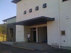
The central shopping area of Ōtsuchi with the town hall and the main train station in its center is known to the locals as "downtown" (machikata) . In this downtown area, 1,422 of the 1,853 houses, which corresponds to around 80%, were completely or half destroyed. All important facilities in Ōtsuchi were destroyed, including the city hall, the police station, the fire station, the hospitals, the library, the main shopping streets and the shopping center. The computers and documents located there were destroyed along with the town hall. Like most of Ōtsuchi, the town hall was decommissioned.
The tsunami caused extensive fire damage, with propane cylinders and the remains of the destroyed houses catching fire. The fires lasted three days and were not limited to the rubble and houses in the area, but also spread to the forests of the surrounding hills, making them impossible to extinguish. This made it extremely difficult for external rescue teams to enter the region, so that many of the villages and evacuation centers in the Ōtsuchi area were completely cut off from the outside world for a few days.
Victim
The isolation of many places in Ōtsuchi due to the fires blocking access for rescue teams from outside made it impossible to verify the safety of the residents of Ōtsuchi, so newspapers and other media sources reported the status of the entire population of Ōtsuchi (over 10,000 people) five days after the tsunami as “ unknown ”reported.
The fire and disaster control authorities reported 766 dead and 952 missing in their damage report on May 19. The number of deaths increased to 855 in the later damage record, while 419 people were still missing.
Depending on the data, the proportion of victims in Ōtsuchi was between 8 and 10 percent of the population. Measured against the total population of Ōtsuchi, which was given as 15,276 in the 2010 census, the casualty rate from the 2011 disaster was 8.3% if all the dead and missing persons registered in the 157th FDMA damage report of March 7, 2018 are taken into account or 8.05% if the victims recorded in the 153rd FDMA damage report of March 8, 2016 (854 dead and 423 missing) minus the catastrophe-related deaths reported by the Reconstruction Agency (RA) are taken into account, resulting in a The figure is 1,229 dead and missing. With the same database, but based solely on the floodplain of the tsunami in Ōtsuchi, the casualty rate was 10.31%.
According to city statistics, the downtown area of machikata had 343 dead and another 325 missing, a loss of 15% of its original population of 4,483.

Immediately after the earthquake, the most important members of the municipal officials working in the town hall had set up tables in the square in front of the town hall for a meeting of the civil protection committee to discuss the risk that the old and somewhat dilapidated town hall could collapse after the earthquake. Around the beginning of the meeting, the first wave of tsunami arrived, taking many of the high-ranking city officials with it, including the mayor, who like others tried to take refuge on the roof of the town hall. The people working in the town hall also got under the floods. Around 40 people fell victim to the tsunami. In addition to its mayor, who was in front of the town hall at the time of the tsunami and was in charge of the disaster control measures, the city also lost 31, 32 or 39 other of its 139 or 146 municipal employees, including seven senior executives, in the tsunami. Controversy arose over whether the town hall in Kamicho should be preserved as a disaster ruin or demolished. The demolition of parts of the town hall began in early June 2016.
The damage recorded in the village of Kiriki was the lowest of all the villages in Ōtsuchi hit by the tsunami. 414 houses in Kiriki were completely or partially destroyed and of the 2,475 residents in 954 households Kiriki had before the tsunami, 100 were recorded dead or missing. This means that the proportion of Kiriki citizens who had lost their lives was around 4%, significantly lower than in the downtown area of Ōtsuchi (with 15%) and other coastal villages such as Ando and Akahama (with 10 to 11%). These statistical results suggest that people in Kiriki, who were well acquainted with the danger of tsunamis, evacuated faster than people in other places in Ōtsuchi.
evacuation
The number of people who lost their homes and sought refuge in one of the city's 38 evacuation centers peaked at 6,200. Together, victims and refugees made up about 50% of the total population of Ōtsuchi.
Ōtsuchi Elementary School in Ōtsuchi City on the main and shopping street was a designated evacuation building. As a result, the tsunami was not expected to reach the school and many people stayed in the school yard, some of them sitting in their vehicles, instead of going to the higher ground on the hill near the school. The tsunami washed over the entire school yard, taking vehicles and people with it.
- Gallery: Devastation in Ōtsuchi after the earthquake and tsunami of March 11, 2011:
Ruins of the Ōtsuchi fire station (Photo: September 1, 2012)
Ōtsuchi City Library (Photo: July 9, 2011)
Ōtsuchi primary school in Ōtsuchi city after the tsunami disaster (大 槌 町 立 大 槌 小学校) (Photo: May 13, 2011)

Bahnhoftsuchi (大 槌 駅) station, years after the disaster (Photo: September 15, 2013)


.jpg)

reconstruction
The death of the mayor and his staff meant that the reconstruction process in Ōtsuchi was slower than in other places. It was five months before the city received a mayor again.
In Ōtsuchi, all facilities and equipment of the local fishing association were damaged. Even months after the disaster, economic activity in this sector had not resumed.
traffic
The most important trunk road is the national road 45 to Sendai or Aomori . Others are prefecture streets 26, 145, 231 and 280.
The city is connected to the rail network via the JR Yamada Line to Morioka Station in Morioka or Kamaishi. Stops are Namiitakaigan ( 浪板 海岸 駅 , -eki ), Kirikiri ( 吉里吉 里 駅 , -eki ) and Ōtsuchi ( 大 槌 駅 , -eki ).
education
In Otsuchi primary schools (are 大槌町立X小学校 , Otsuchi-chōritsu X shōgakkō ) Otsuchi, Ando, Kirikiri, Kozuchi, Akahama, Kanezawa and Otsuchi-Kita ( "Otsuchi-Nord"), the middle schools ( 大槌町立X中学校 , Ōtsuchi- chōritsu X chūgakkō ) Ōtsuchi and Kirikiri, as well as the prefectural high school Ōtsuchi ( 岩手 県 立 大 槌 高等学校 , Iwate-kenritsu Ōtsuchi kōtō gakkō ).
Town twinning
Ōtsuchi has been sister city to Fort Bragg in California since October 15, 2005 .
Web links
- 岩手 県 地震 ・ 津 波 シ ミ ュ レ ー シ ョ ン 及 び 被害 想 定 調査 (overview of the earthquake / tsunami simulation and damage forecast for Iwate): 岩手 県 津 波 浸水 予 測 図 (大 槌 町 Ō (tsunami forecast for the city of Iwate forecast) www2.pref.iwate.jp (Iwate Prefecture). A print version with further information is available as: 岩手 県 地震 ・ 津 波 シ ミ ュ レ ー シ ョ ン 及 び 被害 想 定 調査 に 関 す る 報告 書 (概要 版) ( Memento from June 28, 2018 on WebCite ) (PDF) (岩手ww2.pref.iwate ) (PDF), w 岩手ww2.pref.iwate ), November 2004 (revised: February 2006).
- The tsunami hazard map with its tsunami flood information is based on three tsunami simulations (1st historical Meiji-Sanriku tsunami, 2nd historical Showa-Sanriku tsunami and 3rd predicted Miyagi-Oki earthquake tsunami). The map of the Kokudo Chiriin (国土 地理 院, Geographical Survey Institute = GSI) has been created on a scale of 1: 25000 and is intended for printing on A3 paper . The damage prediction study was carried out by Iwate Prefecture in 2003 and 2004.
- 10 万分 1 浸水 範 囲 概況 図 , 国土 地理 院 ( Kokudo Chiriin , Geospatial Information Authority of Japan, formerly: Geographical Survey Institute = GSI), www.gsi.go.jp: 地理 院 ホ ー ム> 防災 関 連> 平 成 23 年 (2011年) 東北 地方 太平洋 沖 地震 に 関 す る 情報 提供> 10 万分 1 浸水 範 囲 概況 図:
- The GSI published here a map with Otsuchi ( 浸水範囲概況図7 ), on which the 2011 flooded areas are drawn on the basis of reports of aerial photographs and satellite images from the Tōhoku tsunami, as far as was possible.
Individual evidence
- ↑ a b c d e Nobuhito Mori, Daniel T. Cox, Tomohiro Yasuda, Hajime Mase: Overview of the 2011 Tohoku Earthquake Tsunami Damage and Its Relation to Coastal Protection along the Sanriku Coast . In: Earthquake Spectra . tape 29 , S1, 2013, pp. 127-143 , doi : 10.1193 / 1.4000118 .
- ↑ Shoichiro Takezawa: The Aftermath of the 2011 East Japan Earthquake and Tsunami - Living among the Rubble . Lexington Books, Lanham et al. 2016, ISBN 978-1-4985-4251-7 , pp. 1 .
- ↑ a b c Shoichiro Takezawa: The Aftermath of the 2011 East Japan Earthquake and Tsunami - Living among the Rubble . Lexington Books, Lanham et al. 2016, ISBN 978-1-4985-4251-7 , pp. 30th f .
- ↑ a b c d e Shoichiro Takezawa: The Aftermath of the 2011 East Japan Earthquake and Tsunami - Living among the Rubble . Lexington Books, Lanham et al. 2016, ISBN 978-1-4985-4251-7 , pp. 5 f .
- ↑ 津 波 防災 手 帳 大 槌 町 ( Memento from July 16, 2018 on WebCite ) , town.otsuchi.iwate.jp.
- ↑ M. Ando, M. Ishida, Y. Hayashi, C. Mizuki, Y. Nishikawa, Y. Tu: Interviewing insights regarding the fatalities inflicted by the 2011 Great East Japan Earthquake . In: Nat. Hazards Earth Syst. Sci. tape 13 , September 6, 2017, p. 2173-2187 , doi : 10.5194 / nhess-13-2173-2013 . , License: Creative Commons Attribution 3.0 Unported (CC BY 3.0); here: 2179, Fig. 2 b) ("Otsuchi").
- ↑ a b c d e f Tadashi Nakasu, Yuichi Ono, Wiraporn Pothisiri: Why did Rikuzentakata have a high death toll in the 2011 Great East Japan Earthquake and Tsunami disaster? Finding the devastating disaster's root causes . In: International Journal of Disaster Risk Reduction . tape 27 , 2018, p. 21-36 , doi : 10.1016 / j.ijdrr.2017.08.001 . (Published online August 15, 2017). With reference to: Tadashi Nakasu, Yuichi Ono, Wiraporn Pothisiri: Forensic investigation of the 2011 Great East Japan Earthquake and Tsunami disaster: a case study of Rikuzentakata , Disaster Prevention and Management, 26 (3) (2017), pp. 298-313 , doi: 10.1108 / DPM-10-2016-0213 .
- ↑ a b c Nobuo Mimura, Kazuya Yasuhara, Seiki Kawagoe, Hiromune Yokoki, So Kazama: Damage from the Great East Japan Earthquake and Tsunami - A quick report . In: Mitigation and Adaptation Strategies for Global Change . tape 16 , no. 7 , 2011, p. 803-818 , doi : 10.1007 / s11027-011-9304-z . (Published online May 21, 2011).
- ↑ a b Tadashi Nakasu, Yuichi Ono, Wiraporn Pothisiri: Why did Rikuzentakata have a high death toll in the 2011 Great East Japan Earthquake and Tsunami disaster? Finding the devastating disaster's root causes . In: International Journal of Disaster Risk Reduction . tape 27 , 2018, p. 21-36 , doi : 10.1016 / j.ijdrr.2017.08.001 . (Published online on August 15, 2017), here p. 22, table 2.
- ↑ a b Shinichi Omama, Yoshihiro Inoue, Hiroyuki Fujiwara, Tomohiko Mase: First aid stations and patient demand in tsunami-affected areas of Iwate Prefecture following the Great East Japan Earthquake . In: International Journal of Disaster Risk Reduction . tape 31 , 2018, p. 435-440 , doi : 10.1016 / j.ijdrr.2018.06.005 . (First available online on June 12, 2018). License: Creative Commons Attribution-NonCommercial-NoDerivatives 4.0 International (CC BY-NC-ND 4.0).
- ↑ a b 平 成 23 年 (2011 年) 東北 地方 太平洋 沖 地震 (東 日本 大 震災) に つ い て (第 157 報) ( Memento from March 18, 2018 on WebCite ) ( PDF ( Memento from March 18, 2018 on WebCite )), 総 務省 消防 庁 (Fire and Disaster Management Agency), 157th report, March 7, 2018.
- ↑ a b c d e f g h i j Shoichiro Takezawa: The Aftermath of the 2011 East Japan Earthquake and Tsunami - Living among the Rubble . Lexington Books, Lanham et al. 2016, ISBN 978-1-4985-4251-7 , pp. VIIf .
- ↑ a b Anawat Suppasri, Nobuo Shuto, Fumihiko Imamura, Shunichi Koshimura, Erick Mas, Ahmet Cevdet Yalciner: Lessons Learned from the 2011 Great East Japan Tsunami: Performance of Tsunami Countermeasures, Coastal Buildings, and Tsunami Evacuation in Japan . In: Pure and Applied Geophysics . tape 170 , no. 6-8 , 2013, pp. 993-1018 , doi : 10.1007 / s00024-012-0511-7 . (Published online July 7, 2012).
- ↑ a b c d e f Isao Hayashi: Materializing Memories of Disasters: Individual Experiences in Conflict Concerning Disaster Remains in the Affected Regions of the Great East Japan Earthquake and Tsunami . In: Bulletin of the National Museum of Ethnology [ 国立 民族 学 博物館 研究 報告 ] . tape 41 , no. 4 , March 30, 2017, p. 337-391 , doi : 10.15021 / 00008472 .
- ↑ A cruise ship lies on the roof of a two storey building in Otsuchi. (No longer available online.) In: sg.news.yahoo.com. March 25, 2011, archived from the original on July 24, 2012 ; accessed on August 12, 2016 .
- ^ A b Shoichiro Takezawa: The Aftermath of the 2011 East Japan Earthquake and Tsunami - Living among the Rubble . Lexington Books, Lanham et al. 2016, ISBN 978-1-4985-4251-7 , pp. 7 .
- ↑ 平 成 23 年 (2011 年) 東北 地方 太平洋 沖 地震 (第 124 報) ( Memento from March 25, 2018 on WebCite ) ( PDF ( Memento from March 25, 2018 on WebCite )), 総 務 省 消防 庁 (Fire and Disaster Management Agency), 124th report, May 19, 2011.
- ↑ 東 日本 大 震災 図 説 集 . (No longer available online.) In: mainichi.jp. Mainichi Shimbun- sha, May 20, 2011, archived from the original on June 19, 2011 ; Retrieved June 19, 2011 (Japanese, overview of reported dead, missing and evacuated).
- ↑ 平 成 23 年 (2011 年) 東北 地方 太平洋 沖 地震 (第 158 報) ( Memento from October 3, 2018 on WebCite ) , ホ ー ム> 東北 地方 太平洋 沖 地震 (東 日本 大 震災) 被害 報> 【過去】 被害 報> 平 成23 年 (2011 年) 東北 地方 太平洋 沖 地震 被害 報 157 報 ~ (1 月 ~ 12 月) ( Memento from October 3, 2018 on WebCite ) , 総 務 省 消防 庁 (Fire and Disaster Management Agency), 158th damage report, September 7, 2018.
- ↑ a b 東 日本 大 震災 記録 集 ( Memento from March 23, 2018 on WebCite ) , 総 務 省 消防 庁 (Fire and Disaster Management Agency), March 2013, here in Chapter 3 (第 3 章 災害 の 概要) the subsection 3.1 / 3.2 (3.1 被害 の 概要 /3.2 人 的 被害 の 状況) ( PDF ( Memento from March 23, 2018 on WebCite )).
- ↑ 平 成 22 年 国 勢 調査 - 人口 等 基本 集 計 結果 - (岩手 県 , 宮城 県 及 び 福島 県) ( Memento from March 24, 2018 on WebCite ) (PDF, Japanese), stat.go.jp (Statistics Japan - Statistics Bureau , Ministry of Internal Affairs and communication), 2010 Census, Summary of Results for Iwate, Miyagi and Fukushima Prefectures, URL: http://www.stat.go.jp/data/kokusei/2010/index.html .
- ↑ 平 成 23 年 (2011 年) 東北 地方 太平洋 沖 地震 (東 日本 大 震災) に つ い て (第 153 報) ( Memento of March 10, 2016 on WebCite ) , 総 務 省 消防 庁 (Fire and Disaster Management Agency), 153rd report, March 8, 2016.
- ↑ a b c d e f g Supporting and Rmpowering Municipal Functions and Staff . In: Federica Ranghieri, Mikio Ishiwatari (Ed.): Learning from Megadisasters - Lessons from the Great East Japan Earthquake . World Bank Publications, Washington, DC 2014, ISBN 978-1-4648-0153-2 , Chapter 17, pp. 149–153 , doi : 10.1596 / 978-1-4648-0153-2 ( work accessible online on Google Books [accessed April 3, 2018]). , License: Creative Commons Attribution CC BY 3.0 IGO.
- ^ A b c Protecting Significant and Sensitive Facilities . In: Federica Ranghieri, Mikio Ishiwatari (Ed.): Learning from Megadisasters - Lessons from the Great East Japan Earthquake . World Bank Publications, Washington, DC 2014, ISBN 978-1-4648-0153-2 , Chapter 5, pp. 55–62 , doi : 10.1596 / 978-1-4648-0153-2 ( work accessible online on Google Books [accessed April 3, 2018]). , License: Creative Commons Attribution CC BY 3.0 IGO.
- ↑ cf. Anawat Suppasri, Nobuo Shuto, Fumihiko Imamura, Shunichi Koshimura, Erick Mas, Ahmet Cevdet Yalciner: Lessons Learned from the 2011 Great East Japan Tsunami: Performance of Tsunami Countermeasures, Coastal Buildings, and Tsunami Evacuation in Japan . In: Pure and Applied Geophysics . tape 170 , no. 6-8 , 2013, pp. 993-1018 , doi : 10.1007 / s00024-012-0511-7 . (Published online on July 7, 2012), here: p. 1009, Figure 22. License: Creative Commons Attribution 2.0 Generic (CC BY 2.0).
- ↑ Death toll to top 15,000 in quake hit Miyagi alone. (No longer available online.) In: Kyodo News . March 20, 2011, archived from the original on March 20, 2011 ; accessed on August 12, 2016 .
- ↑ a b c d e Stephanie Chang et al .: The March 11, 2011, Great East Japan (Tohoku) Earthquake and Tsunami: Societal Dimensions . In: EERI Special Earthquake Report . August 2011, p. 1-23 . Earthquake Engineering Research Institute (EERI).
- ↑ Shoichiro Takezawa: The Aftermath of the 2011 East Japan Earthquake and Tsunami - Living among the Rubble . Lexington Books, Lanham et al. 2016, ISBN 978-1-4985-4251-7 , pp. 8-10 .
Remarks
Independent cities ( shi ): Hachimantai | Hanamaki | Ichinoseki | Kamaishi | Kitakami | Kuji | Miyako | Morioka (administrative headquarters) | Ninohe | Ōfunato | Ōshū | Rikuzentakata | Takizawa | Tono
Isawa-gun : Kanegasaki | Iwate-gun : Iwate | Kuzumaki | Shizukuishi | Kamihei-gun : Ōtsuchi | Kesen-gun : Sumita | Kunohe-gun : Karumai | Kunohe | Noda | Hirono | Ninohe-gun : Ichinohe | Nishiiwai-gun : Hiraizumi | Shimohei-gun : Fudai | Iwaizumi | Tanohata | Yamada | Shiwa-gun : Shiwa | Yahaba | Waga-gun : Nishiwaga