
Yamada (Iwate)
| Yamada-machi 山田 町 |
|||
|---|---|---|---|
|
|||
| Geographical location in Japan | |||
| Region : | Tōhoku | ||
| Prefecture : | Iwate | ||
| Coordinates : | 39 ° 28 ' N , 141 ° 57' E | ||
| Basic data | |||
| Surface: | 263.45 km² | ||
| Residents : | 14,691 (October 1, 2019) |
||
| Population density : | 56 inhabitants per km² | ||
| Community key : | 03482-7 | ||
| Symbols | |||
| Flag / coat of arms: |
 |
||
| Tree : | Crescent fir | ||
| Flower : | Potato rose | ||
| Bird : | Japanese gull | ||
| town hall | |||
| Address : |
Yamada Town Hall 3 - 20 , Hachimanchō Yamada - machi , Shimohei-gun Iwate 028-1392 |
||
| Website URL: | www.town.yamada.iwate.jp | ||
| Location of Yamadas in Iwate Prefecture | |||
 |
|||

Yamada ( Japanese 山田 町 , - machi ) is a city in Shimohei County in Iwate Prefecture on Honshū , the main island of Japan .
geography

Yamada is located on the Pacific coast along the Sanriku-Ria coast along Yamada Bay ( 山 田湾 , Yamada-wan ) and the north shore of Funakoshi Bay ( 船 越 湾 , Funakoshi-wan ), both separated from each other by the Funakoshi Peninsula ( 船 越 半島 , Funakoshi-hantō ). There are several smaller islands in Yamada Bay, the largest being Ōshima ( ima 島 , "big island") or Oranda-jima ( オ ラ ン ダ 島 , "Holland island"). Like the other islands, it is uninhabited, but it is a popular seaside resort in summer and there is also a ferry connection. In the immediate vicinity is Kojima ( 小島 , "small island").
The municipal area consists for the most part of mountainous land, whereby the Takadakimori ( 高 darstellt 森 ) with 1160.3 m height on the western border to the neighboring municipality Ōtsuchi represents the highest peak. The Jūnishin-zan ( 十二 神山 ) with 731.4 m is located on the northern border of Miyako, which is adjacent to Wells. The dominant mountain on the Funakoshi Peninsula is the Karogadake ( 霞 露 ヶ 岳 ) with 504.2 m.
The settlement of the community is concentrated due to the many mountains on the coasts and river valleys. In the north of the municipality there is a larger river valley from the confluences of various rivers into the Tsugaruishi River ( 津 軽 石川 ) coming from Miyako . In the northern part of the plain is the district Ishitōge ( 石 峠 ), in the western foothills with the Arakawa River ( 荒 川川 , Arakawa-kawa ) the district Arakawa ( 荒 川 ) and in the southern part Toyomane ( 豊 間 根 ). On the north bank of Yamada Bay at the mouth of the Ōsawa River ( 大 沢 川 , Ōsawa-kawa ) is Ōsawa ( 大 沢 ), then on the west bank clockwise Yamada at the mouth of the Sekiguchi River ( 関口 川 , Sekiguchi-kawa ), on which directly to the south is a wider coastal strip with the community center, consisting of the districts Kitahama-chō ( 北 浜 町 ), Kōraku-chō ( 後 楽 町 ), Hachiman-chō ( 八 幡 町 ), Chūō-chō ( 中央 町 ), Nagasaki ( 長崎 ) , Kawamukai-chō ( 川 向 町 ) and Sakaida-chō ( 境 田 町 ), as well as Iioka ( 飯 岡 ) a little inland. On the southwest of the bay the Orikasa River ( 織 笠 川 , Orikasa-kawa ) flows into this and in its estuary is the Orikasa district of the same name ( 織 笠 ) and upstream where the 馬 指 野 川 connects with Todoroki. Funakoshi ( Süd 越 ) is located on the land bridge between the south bank of Yamada Bay and the north bank of Funakoshi Bay and the peninsula .
history
In 1643 the Dutch ship Breskens from the expedition fleet of Maarten Gerritszoon de Vries landed on the island of Ōshima. For this reason it is also known as Oranda-jima "Holland Island".
As a city (machi) , Yamada was established in 1889 when the Meiji government established modern local authorities by merging the villages ( mura ) Yamada and Iioka in what was then Higashihei County . In 1955, Yamada and the villages of Funakoshi, Orikasa, Ōsawa and Toyomane from the district, now merged with the districts of Nakahei and Kitahei to form Shimohei, were united and the new Yamada was formed.
Earthquake and tsunami disasters

red : predicted flood plains based on the union of three earthquake types: the historical Meiji-Sanriku-oki and Shōwa-Sanriku-oki and the hypothetical Miyagi-oki
black numbers : flood or run-up heights [m] from March 11, 2011
blue : floodplains March 11, 2011
column charts : population (left) and dead (right) for ages 0-15 (below), 16-64 (center) and ≥65 (top)

| Disaster event | Completely destroyed houses | Death toll | source |
|---|---|---|---|
| Meiji 1896 (earthquake and tsunami) | 814 | 2124 | |
| Shōwa 1933 (earthquake and tsunami) | 551 | 20th | |
| Chile 1960 (earthquake and tsunami) | 133 | 0 | |
| Tōhoku 2011 (earthquake and tsunami) | 2789 | 752 | |
| Note: The death toll for the 2011 Tōhoku disaster is calculated from the total number of dead and missing in the 153rd FDMA damage report of March 8, 2016, minus the figures for catastrophe-related deaths determined by the Reconstruction Agency (RA). | |||
2011 Tōhoku earthquake
Extent of flooding and damage
The city of Yamada was struck by a tsunami after the Tōhoku earthquake in 2011 on March 11, 2011 , the damage of which was intensified by the Ria coast, especially since the center of the village is at the end of the long mountain-lined Yamada Bay, and the mountains that rise nearby. The city's coastal area was flooded and fires broke out. The tsunami reached heights between 6 and 8 m in Yamada Bay, while the heights further north outside the bay reached over 20 m. The city of Yamada suffered severe damage, although the corresponding tsunami heights were relatively low.
Five of the seven central districts of downtown on Yamada Bay were wiped out. The number of completely destroyed houses is put at 2762. The city's only hospital and three of the four clinics were damaged by the tsunami. Like wietsuchi, Noda and Rikuzentakata, Yamada was one of the cities in Iwate Prefecture where most of the medical facilities lost their functionality. 61.3% of Yamada's 18,745 residents lived in the floodplain.
The city of Yamada includes moderately extensive lowland areas along the bay and has been protected by a combination of old and new tsunami breakwaters. The height of the old breakwater was 4.0 m, while the design height of the new breakwater was 6.6 m above the local mean sea level. The effective heights could be a few decimeters lower than the design heights due to the coseismic subsidence. In fact, the height of the tsunami barely exceeded the new breakwaters, but the old breakwater segments on the sides allowed massive trespassing and flooding into the city, causing significant property damage and death. A six meter high breakwater was destroyed by the tsunami.
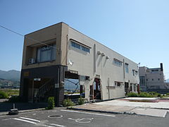
In the Whale & Marine Science Museum (鯨 と 海 の 科学館) tsunami traces up to a height of 5 m were found. The skeleton of a male sperm whale (Physeter macrocephalus) hanging from the ceiling on the first floor, 17.6 m long, which was caught in the last season of commercial whaling in November 1987 off the town of Yamada, which was once known for its whaling, remained like the skeleton exhibit of a minke whale (Balaenoptera acutorostrata) hanging next to it, largely undamaged despite soiling. However, the outside walls of the museum were damaged and almost half of the 2,000 exhibition materials were lost. The museum was closed and reopened on July 15, 2017 after the restoration of the facilities and exhibits.
Victim
The Fire and Disaster Management Agency (FDMA) reported 687 dead and 146 missing by its 157th damage report in 2018.
Measured against the total population of Yamada, which was given as 18,617 in the 2010 census, the casualty rate from the 2011 disaster was 4.5% when all dead and missing persons recorded in the 157th FDMA damage report of March 7, 2018 are included or 4.04% if the victims recorded in the 153rd FDMA damage report of March 8, 2016 (687 dead and 148 missing) minus the catastrophe-related deaths reported by the Reconstruction Agency (RA) are taken into account, resulting in a Number of 752 dead and missing results. With the same database, but based solely on the floodplain area of the tsunami in Yamada, which covered an area of 5 km 2 , the casualty rate was 6.59%. The casualty rate of around 4% is high compared to other cities on the Sanriku Coast.
- Gallery: Devastation in Yamada after the earthquake and tsunami of March 11, 2011:

Destroyed steel-reinforced buildings (Photo: April 30, 2011)
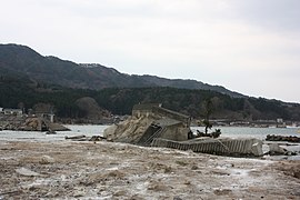
Destroyed coastal protection structures (Photo: April 30, 2011)
Shop in downtown Yamada. The first floor has been destroyed, the second is in use (June 1, 2013)

The roof of the tsunami-damaged Whale & Marine Science Museum behind a mound of rubble (Photo: July 17, 2011)

Damaged exhibit of a whale of the genus Balaenoptera in the Whale & Marine Science Museum (June 8, 2011)
.jpg)
.jpg)


traffic

The most important highways of the municipality are the Sanriku Highway to Sendai or Miyako, and the National Road 45 to Sendai or Aomori .
There is a connection to the rail network via the JR East Yamada Line to Morioka Station in Morioka or Kamaishi Station in Kamaishi . The stops on the line within the community are Toyomane, Rikuchu-Yamada, Orikasa, and Iwate-Funakoshi.
education
In the community there are the primary schools Yamada-South ( 山田 町 立 山田 南 小学校 , Yamada-chōritsu Yamada Minami shōgakkō ), Yamada-North ( 山田 町 立 山田 北 小学校 , ~ Yamada Kita ~ ), Ōsawa ( 山田 町 立 大 沢 小学校 ), Ōura ( 山田 町 立 大 浦 小学校 ), Orikasa ( 山田 町 立 織 笠 小学校 ), Funakoshi ( 山田 町 立 小学校 ), Todoroki ( 山田 町 立 轟 木 小学校 ), Arakawa ( 山田 町 立 荒 川 小学校 ) and Toyomane ( 小学校 間 町 立 豊 豊ada ) ( 山田 間 町 立 豊 ada 山田 町 立 山田 中 学校 , Yamada-chōritsu Yamada chūgakkō ) and Toyomane ( 山田 町 立 豊 間 根 中 学校 ), as well as the prefectural high school Yamada ( 岩手 県 立 山田 高等学校 , Iwate-kenritsu Yamada kōtō gakkō ).
Town twinning
On October 20, 1985, the parish became a sister city with its namesake in Chiba Prefecture . When that Chiba in 2006 in Katori was taken over the city relationship. On August 2, 1990, a city friendship with Hiraka followed , which was also maintained after its incorporation in 2006 in Hirakawa .
The only foreign city friendship was made on May 13, 2000 with the Dutch Zeist .
sons and daughters of the town
- Suzuki Zenkō (1911-2004), Prime Minister of Japan
Web links
- 岩手 県 地震 ・ 津 波 シ ミ ュ レ ー シ ョ ン 及 び 被害 想 定 調査 (overview of earthquake / tsunami simulation and damage prognosis for Iwate): 岩手 県 津 波 浸水 予 測 図 (山田 町,, diagram for the prefecture of Iwada inundation of the city of Yamada (tsunami inundation) www2.pref.iwate.jp (Iwate Prefecture). A print version with further information is available as: 岩手 県 地震 ・ 津 波 シ ミ ュ レ ー シ ョ ン 及 び 被害 想 定 調査 に 関 す る 報告 書 (概要 版) ( Memento from June 28, 2018 on WebCite ) (PDF) (岩手ww2.pref.iwate ) (PDF), w 岩手ww2.pref.iwate ), November 2004 (revised: February 2006).
- The tsunami hazard map with its tsunami flood information is based on three tsunami simulations (1st historical Meiji-Sanriku tsunami, 2nd historical Showa-Sanriku tsunami and 3rd predicted Miyagi-Oki earthquake tsunami). The map of the Kokudo Chiriin (国土 地理 院, Geographical Survey Institute = GSI) has been created on a scale of 1: 25000 and is intended for printing on A3 paper . The damage prediction study was carried out by Iwate Prefecture in 2003 and 2004.
- 10 万分 1 浸水 範 囲 概況 図 , 国土 地理 院 ( Kokudo Chiriin , Geospatial Information Authority of Japan, formerly: Geographical Survey Institute = GSI), www.gsi.go.jp: 地理 院 ホ ー ム> 防災 関 連> 平 成 23 年 (2011年) 東北 地方 太平洋 沖 地震 に 関 す る 情報 提供> 10 万分 1 浸水 範 囲 概況 図:
- The GSI published here a map with Yamada ( 浸水範囲概況図6 ) on which the 2011 flooded areas are drawn on the basis of reports of aerial photographs and satellite images from the Tōhoku tsunami, as far as was possible.
Individual evidence
- ↑ M. Ando, M. Ishida, Y. Hayashi, C. Mizuki, Y. Nishikawa, Y. Tu: Interviewing insights regarding the fatalities inflicted by the 2011 Great East Japan Earthquake . In: Nat. Hazards Earth Syst. Sci. tape 13 , September 6, 2017, p. 2173-2187 , doi : 10.5194 / nhess-13-2173-2013 . , License: Creative Commons Attribution 3.0 Unported (CC BY 3.0); here: 2179, Fig.2 a) ("Yamada").
- ↑ Anawat Suppasri, Nobuo Shuto, Fumihiko Imamura, Shunichi Koshimura, Erick Mas, Ahmet Cevdet Yalciner: Lessons Learned from the 2011 Great East Japan Tsunami: Performance of Tsunami Countermeasures, Coastal Buildings, and Tsunami Evacuation in Japan . In: Pure and Applied Geophysics . tape 170 , no. 6-8 , 2013, pp. 993-1018 , doi : 10.1007 / s00024-012-0511-7 . (Published online on July 7, 2012), here: p. 997, Figure 8. License: Creative Commons Attribution 2.0 Generic (CC BY 2.0).
- ↑ a b c d e f Tadashi Nakasu, Yuichi Ono, Wiraporn Pothisiri: Why did Rikuzentakata have a high death toll in the 2011 Great East Japan Earthquake and Tsunami disaster? Finding the devastating disaster's root causes . In: International Journal of Disaster Risk Reduction . tape 27 , 2018, p. 21-36 , doi : 10.1016 / j.ijdrr.2017.08.001 . (Published online August 15, 2017). With reference to: Tadashi Nakasu, Yuichi Ono, Wiraporn Pothisiri: Forensic investigation of the 2011 Great East Japan Earthquake and Tsunami disaster: a case study of Rikuzentakata , Disaster Prevention and Management, 26 (3) (2017), pp. 298-313 , doi: 10.1108 / DPM-10-2016-0213 .
- ↑ Quake death toll feared to top 1,800; thousands more unaccounted for. (No longer available online.) In: Japan Today. March 13, 2011, archived from the original on March 13, 2011 ; accessed on August 12, 2016 .
- ↑ a b c Akio Okayasu, Takenori Shimozono, Shinji Sato, Yoshimitsu Tajima, Haijiang Liu, Tomohiro Takagawa, Hermann M. Fritz: 2011 Tohoku Tsunami runup and devastating damages around Yamada Bay, Iwate: Surveys and numerical simulation . In: Coastal Engineering Proceedings . tape 1 , no. 33 , December 2012, p. 1-14 , doi : 10.9753 / icce.v33.currents.4 .
- ↑ a b Earthquake-ravaged Iwate town lies in smoldering ruins. (No longer available online.) In: Mainichi Shimbun. March 14, 2011, archived from the original on March 15, 2011 ; accessed on April 24, 2011 .
- ↑ a b c 平 成 23 年 (2011 年) 東北 地方 太平洋 沖 地震 (東 日本 大 震災) に つ い て (第 157 報) ( Memento from March 18, 2018 on WebCite ) ( PDF ( Memento from March 18, 2018 on WebCite )),総 務 省 消防 庁 (Fire and Disaster Management Agency), March 7, 2018.
- ↑ 東 日本 大 震災 図 説 集 . (No longer available online.) In: mainichi.jp. Mainichi Shimbun- sha, May 20, 2011, archived from the original on June 19, 2011 ; Retrieved June 19, 2011 (Japanese, overview of reported dead, missing and evacuated).
- ↑ Shinichi Omama, Yoshihiro Inoue, Hiroyuki Fujiwara, Tomohiko Mase: First aid stations and patient demand in tsunami-affected areas of Iwate Prefecture following the Great East Japan Earthquake . In: International Journal of Disaster Risk Reduction . tape 31 , 2018, p. 435-440 , doi : 10.1016 / j.ijdrr.2018.06.005 . (First available online on June 12, 2018). License: Creative Commons Attribution-NonCommercial-NoDerivatives 4.0 International (CC BY-NC-ND 4.0).
- ↑ a b 津 波 乗 り 越 え た ク ジ ラ の 標本 「復興 の 象 徴」 岩手 ・ 山田 ( Memento from May 1, 2018 on WebCite ) , asahi.com, April 7, 2011, 杉 崎 慎 弥.
- ↑ 鯨 と 海 の 科学館 7 月 15 日 再 開 ( Memento from May 1, 2018 on WebCite ) , kahoku.co.jp, June 17, 2017.
- ↑ 平 成 22 年 国 勢 調査 - 人口 等 基本 集 計 結果 - (岩手 県 , 宮城 県 及 び 福島 県) ( Memento from March 24, 2018 on WebCite ) (PDF, Japanese), stat.go.jp (Statistics Japan - Statistics Bureau , Ministry of Internal Affairs and communication), 2010 Census, Summary of Results for Iwate, Miyagi and Fukushima Prefectures, URL: http://www.stat.go.jp/data/kokusei/2010/index.html .
- ↑ Tadashi Nakasu, Yuichi Ono, Wiraporn Pothisiri: Why did Rikuzentakata have a high death toll in the 2011 Great East Japan Earthquake and Tsunami disaster? Finding the devastating disaster's root causes . In: International Journal of Disaster Risk Reduction . tape 27 , 2018, p. 21-36 , doi : 10.1016 / j.ijdrr.2017.08.001 . (Published online on August 15, 2017), here p. 22, table 2.
- ↑ 平 成 23 年 (2011 年) 東北 地方 太平洋 沖 地震 (東 日本 大 震災) に つ い て (第 153 報) ( Memento of March 10, 2016 on WebCite ) , 総 務 省 消防 庁 (Fire and Disaster Management Agency), 153rd report, March 8, 2016.
- ↑ Junko Sagara: Multifunctional Infrastructure . In: Federica Ranghieri, Mikio Ishiwatari (Ed.): Learning from Megadisasters - Lessons from the Great East Japan Earthquake . World Bank Publications, Washington, DC 2014, ISBN 978-1-4648-0153-2 , Chapter 4, pp. 49–53 , doi : 10.1596 / 978-1-4648-0153-2 ( work accessible online on Google Books [accessed on April 3, 2018]). , License: Creative Commons Attribution CC BY 3.0 IGO, here pp. 49–51, Figure 4.2 "The Sanriku Expressway was built with tsunamis in mind - Source: MLIT."
Remarks
Independent cities ( shi ): Hachimantai | Hanamaki | Ichinoseki | Kamaishi | Kitakami | Kuji | Miyako | Morioka (administrative headquarters) | Ninohe | Ōfunato | Ōshū | Rikuzentakata | Takizawa | Tono
Isawa-gun : Kanegasaki | Iwate-gun : Iwate | Kuzumaki | Shizukuishi | Kamihei-gun : Ōtsuchi | Kesen-gun : Sumita | Kunohe-gun : Karumai | Kunohe | Noda | Hirono | Ninohe-gun : Ichinohe | Nishiiwai-gun : Hiraizumi | Shimohei-gun : Fudai | Iwaizumi | Tanohata | Yamada | Shiwa-gun : Shiwa | Yahaba | Waga-gun : Nishiwaga