Tanohata (Iwate)
| Tanohata-mura 田野 畑 村 |
||
|---|---|---|
|
|
||
| Geographical location in Japan | ||
| Region : | Tōhoku | |
| Prefecture : | Iwate | |
| Coordinates : | 39 ° 56 ' N , 141 ° 53' E | |
| Basic data | ||
| Surface: | 156.19 km² | |
| Residents : | 3140 (October 1, 2019) |
|
| Population density : | 20 inhabitants per km² | |
| Community key : | 03484-3 | |
| Symbols | ||
| Flag / coat of arms: | ||
| Tree : | Bluebell tree | |
| Flower : | Rhododendron brachycarpum var. Roseum | |
| Bird : | Copper pheasant | |
| town hall | ||
| Address : |
Tanohata Village Hall 143 - 1 , Tanohata Tanohata -mura, Shimohei-gun Iwate 028-8407 |
|
| Website URL: | www.vill.tanohata.iwate.jp | |
| Location of Tanohatas in Iwate Prefecture | ||
Tanohata ( Japanese 田野 畑 村 , - mura ) is a village community in Shimohei County in the east of Iwate Prefecture in Japan .
geography
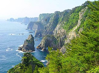
Tanohata is located on the Pacific Ocean on the northern Sanriku coast, which is characterized by steep cliffs . The 200 m high Kitayama Cliffs ( 北山崎 , Kitayama-Zaki ) to 8 km in length in the Northeast and the equally high Unosu- demolition edge ( 鵜ノ巣断崖 , Unosu-Dangai ) are in the southeastern part of the Sanriku Fukko National Parks . There are only a few sandy beaches, the settlement is concentrated on a large number of hamlets in the extensive terraces in the hinterland, as well as the mountain valleys, river valleys and estuaries.
Tanohata is south of Fudai and north of Iwaizumi .
history
Today's Tanohata community emerged from the reorganization of the community on April 1, 1889 from the union of the old Tanohata with the villages of Hamaiwazumi ( 浜 岩 泉村 ) in the south of it and Numabukuro ( 沼 袋 村 ) in the west, deep in the mountains, each in the Kitahei district . This county was merged with Nakahei and Higashihei to form Shimohei County on March 29, 1896.
Earthquake and tsunami disasters

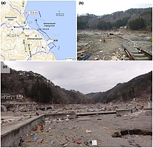
a: run-up heights (circles)
b, c: tsunami damage
Historical tsunami experiences
Along the central Sanriku coast between 39.0 and 40.2 ° north latitude , the tsunami triggered by the Tōhoku earthquake reached heights of 5 to 40 m on September 11, 2011. There had been various tsunamis in this region in history, of which the Meiji-Sanriku tsnuami in 1896 reached roughly the same heights as in 2011, while the Shōwa-Sanriku tsunami in 1933 was smaller and the Chile tsunamis of 1960 and 2010 far were lower than the 2011 tsunami.
For the raga belonging to the village of Tanohata, tsunami heights of 18 m, 23 m and 24–26 m were reported for the tsunami of 1896, depending on the source. For a tsunami stone transported by the tsunami in 1896, an altitude of 28.2 ± 1.2 m above TP was scientifically calculated. On this basis, a maximum incidence height of the tsunami of 1896 in Raga of possibly over 30 m was assumed. A height of 13 m had been reported for the 1933 tsunami, while the 1960 tsunami was 1 m.
| Disaster event | Completely destroyed houses | Death toll | source |
|---|---|---|---|
| Meiji 1896 (earthquake and tsunami) | 53 | 232 | |
| Shōwa 1933 (earthquake and tsunami) | 131 | 83 | |
| Tōhoku 2011 (earthquake and tsunami) | 225 | 29 | |
| Note: The death toll for the 2011 Tōhoku disaster is calculated from the total number of dead and missing in the 153rd FDMA damage report of March 8, 2016, minus the figures for catastrophe-related deaths determined by the Reconstruction Agency (RA). | |||
Tōhoku disaster 2011
On 11 March 2011 by the teaching Tōhoku earthquake -triggered tsunami severe devastation to in this seaside districts, flood protection, despite their fight . The tsunami reached a height of around 20 meters near Tanohata, while a height of almost 15 meters was planned for the dikes, of which only about 6 meters had been realized. In Raga, the 2011 tsunami, like that of 1896, was much greater than that of 1933. The Tsuji & al. The tsunami heights of the 2011 tsunami reported in 2014 were 23 to 28 m. The limit of the flooding in Raga was just below the height at which a tsunami rock washed up by the tsunami in 1896 lay.
225 houses were completely destroyed and 45 others partially destroyed. The Shimanokoshi station of the Sanriku Railway (三 陸 鉄 道 Sanriku Tetsudō) and its tracks were torn away on a 10 m high reinforced concrete bridge . All of the houses in Shimanokoshi except two on top of a hill were washed away or torn down by the tsunami. A tsunami run-up height of 22.0 m was measured in the forecourt of one of the surviving houses. On the northern slope near the dai-ni (second) Shimanokoshi tunnel, a run-up height measurement showed 19.9 m. A large amount of wood building materials and debris was deposited throughout the tunnel.
The coastal dike in the Aketo area suffered significant damage from the tsunami. It was decided to keep this former coastal dike as the center of a memorial park to be developed by the village of Tanohata, which will serve to convey lessons from civil protection. The former coastal dike was the second disaster ruin in Iwate Prefecture to be preserved through national funding.
The Fire and Disaster Management Agency (FDMA) reported 17 dead and 15 missing.
traffic
Important highways to Tanohata are the national road 45 to Sendai or Aomori , whereby the section between Fudai and Iwaizumi is called the Sanriku-Kita-Crossing Road ( 三 陸 北 縦 貫 道路 , Sanriku-Kita jūkan dōro ). There are also prefecture roads 44 and 173 in the municipality.
Fudai is connected to the rail network via the Kita-Rias Line (North Rias Line) operated by the Sanriku Tetsudō railway company. This leads to the main train stations of Miyako or Kuji . The stops in Tanohata are Shimanokoshi ( 島 越 駅 , -eki ) and Tanohata ( 田野 畑 駅 , -eki ). However, the former was washed away in the March 11, 2011 tsunami.
education
Tanohata has an elementary school, middle school, and prefectural high school.
Town twinning
In February 1997 Tanohata made a friendship with the Japanese Kawamoto , which was also taken over when the latter was incorporated into Fukaya in 2006 .
Web links
- 岩手 県 地震 ・ 津 波 シ ミ ュ レ ー シ ョ ン 及 び 被害 想 定 調査 (overview of the earthquake / tsunami simulation and damage prognosis for Iwate): 岩手 県 津 波 浸水 予 測 図 (田野 畑, for the prefecture of Iwate village (tsunami inundate forecast ) www2.pref.iwate.jp (Iwate Prefecture). A print version with further information is available as: 岩手 県 地震 ・ 津 波 シ ミ ュ レ ー シ ョ ン 及 び 被害 想 定 調査 に 関 す る 報告 書 (概要 版) ( Memento from June 28, 2018 on WebCite ) (PDF) (岩手ww2.pref.iwate ) (PDF), w 岩手ww2.pref.iwate ), November 2004 (revised: February 2006).
- The tsunami hazard map with its tsunami flood information is based on three tsunami simulations (1st historical Meiji-Sanriku tsunami, 2nd historical Showa-Sanriku tsunami and 3rd predicted Miyagi-Oki earthquake tsunami). The map of the Kokudo Chiriin (国土 地理 院, Geographical Survey Institute = GSI) has been created on a scale of 1: 25000 and is intended for printing on A3 paper . The damage prediction study was carried out by Iwate Prefecture in 2003 and 2004.
- 10 万分 1 浸水 範 囲 概況 図 , 国土 地理 院 ( Kokudo Chiriin , Geospatial Information Authority of Japan, formerly: Geographical Survey Institute = GSI), www.gsi.go.jp: 地理 院 ホ ー ム> 防災 関 連> 平 成 23 年 (2011年) 東北 地方 太平洋 沖 地震 に 関 す る 情報 提供> 10 万分 1 浸水 範 囲 概況 図:
- The GSI published here a map with Tanohata ( 浸水範囲概況図5 ) on which the 2011 flooded areas are drawn on the basis of reports of aerial photographs and satellite images from the Tōhoku tsunami, as far as was possible.
Individual evidence
- ↑ 三 陸 復興 国立 公園 見 ど こ ろ ガ イ ド . Ministry of the Environment , accessed August 12, 2016 (Japanese).
- ↑ 三 陸 復興 国立 公園 公園 の 特長 . Ministry of the Environment , accessed August 12, 2016 (Japanese).
- ↑ Yoshinobu Tsuji, Kenji Satake, Takeo Ishibe, Tomoya Harada, Akihito Nishiyama, Satoshi Kusumoto: Tsunami Heights along the Pacific Coast of Northern Honshu Recorded from the 2011 Tohoku . In: Pure and Applied Geophysics . tape 171 , no. 12 , 2014, p. 3183-3215 , doi : 10.1007 / s00024-014-0779-x . (Published online March 19, 2014). License: Creative Commons Attribution 4.0 International (CC BY 4.0). Here: p. 3187, Figure 4.
- ↑ a b c d e Yoshinobu Tsuji, Kenji Satake, Takeo Ishibe, Tomoya Harada, Akihito Nishiyama, Satoshi Kusumoto: Tsunami Heights along the Pacific Coast of Northern Honshu Recorded from the 2011 Tohoku and Previous Great Earthquakes . In: Pure and Applied Geophysics . tape 171 , no. 12 , 2014, p. 3183-3215 , doi : 10.1007 / s00024-014-0779-x . (First published online on March 19, 2014). License: Creative Commons Attribution License.
- ↑ a b c d e Tadashi Nakasu, Yuichi Ono, Wiraporn Pothisiri: Why did Rikuzentakata have a high death toll in the 2011 Great East Japan Earthquake and Tsunami disaster? Finding the devastating disaster's root causes . In: International Journal of Disaster Risk Reduction . tape 27 , 2018, p. 21-36 , doi : 10.1016 / j.ijdrr.2017.08.001 . (Published online August 15, 2017). With reference to: Tadashi Nakasu, Yuichi Ono, Wiraporn Pothisiri: Forensic investigation of the 2011 Great East Japan Earthquake and Tsunami disaster: a case study of Rikuzentakata , Disaster Prevention and Management, 26 (3) (2017), pp. 298-313 , doi: 10.1108 / DPM-10-2016-0213 .
- ↑ 東 日本 大 震災 図 説 集 . (No longer available online.) In: mainichi.jp. Mainichi Shimbun- sha, May 20, 2011, archived from the original on June 19, 2011 ; Retrieved June 19, 2011 (Japanese, overview of reported dead, missing and evacuated).
- ↑ Mikio Ishiwatari, Junko Sagara: Structural Measures Against Tsunamis . In: Federica Ranghieri, Mikio Ishiwatari (Ed.): Learning from Megadisasters - Lessons from the Great East Japan Earthquake . World Bank Publications, Washington, DC 2014, ISBN 978-1-4648-0153-2 , Chapter 1, pp. 25–32 , doi : 10.1596 / 978-1-4648-0153-2 ( work accessible online on Google Books [accessed on April 3, 2018]). , License: Creative Commons Attribution CC BY 3.0 IGO.
- ↑ 平 成 23 年 (2011 年) 東北 地方 太平洋 沖 地震 (東 日本 大 震災) に つ い て (第 157 報) ( Memento of March 18, 2018 on WebCite ) ( PDF ( Memento of March 18, 2018 on WebCite )), 総 務 省 消防庁 (Fire and Disaster Management Agency), March 7, 2018.
- ↑ a b 三 陸 鉄 道 「国 の 支援 な け れ ば 、 も は や 何 も…」 . (No longer available online.) In: Yomiuri Online. Yomiuri Shimbun- sha, April 5, 2011, archived from the original on May 1, 2011 ; Retrieved May 1, 2011 (Japanese).
- ^ Isao Hayashi: Materializing Memories of Disasters: Individual Experiences in Conflict Concerning Disaster Remains in the Affected Regions of the Great East Japan Earthquake and Tsunami . In: Bulletin of the National Museum of Ethnology [ 国立 民族 学 博物館 研究 報告 ] . tape 41 , no. 4 , March 30, 2017, p. 337-391 , doi : 10.15021 / 00008472 .
- ↑ 平 成 23 年 (2011 年) 東北 地方 太平洋 沖 地震 (東 日本 大 震災) に つ い て (第 153 報) ( Memento of March 10, 2016 on WebCite ) , 総 務 省 消防 庁 (Fire and Disaster Management Agency), March 8, 2016 .


