
Tarawa
| Tarawa | ||
|---|---|---|
 |
||
| Waters | Pacific Ocean | |
| archipelago | Gilbert Islands | |
| Geographical location | 1 ° 25 ′ N , 173 ° 2 ′ E | |
|
||
| Number of islands | 24 | |
| Main island | Bonriki | |
| length | 39 km | |
| Land area | 32 km² | |
| Lagoon area | 343.6 km² | |
| total area | 490 km² | |
| Residents | 63,017 (2015) | |
 |
||

Tarawa (in previous spelling also: Tarowa , former name Cook Island ) is an atoll in the Pacific Ocean with 63,017 inhabitants (as of 2015), mainly from the Micronesian ethnic group . The atoll was formerly the main atoll of the former British colony of the Gilbert and Ellice Islands , then that of the Gilbert Islands . Today it is the main atoll of the Republic of Kiribati with the capital South Tarawa .
geography
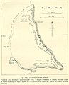
Tarawa consists of at least 24 islands, 16 of which are inhabited. The largest island is Bonriki , on which the Bonriki International Airport is located, currently the only international airport served by Kiribati. The largest city is Betio on the island of the same name in the southwest of the atoll. It has an angular shape with a north-south chain of islands ( North Tarawa ) and an east-west chain of islands ( South Tarawa ) adjoining it in the south . Both bound a lagoon open to the west .
Cities and villages
Abaokoro - Abatao - Bairiki - Betio - Bikenibeu - Buariki - Buota - Eita - Marenanuka - Nabeina - Nooto - Taborio - Teaoraereke - Tebwangaroi
cards

Nautical chart from 1873
World War II map
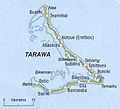
Current map


administration
The atoll has several administrative units:
- Teinainano Urban Council (TUC) from Bairiki to Bonriki, better known as South Tarawa . This district is the capital of the republic
- Betio Town Council (BTC) on the small island of Betio
- Tarawa Ieta or North Tarawa (all islands in the north)
The main administrative center for the Republic of Kiribati is on Bairiki , one of the southernmost islands of Tarawa. However, some ministries are on Betio and Bikenibeu, one on Kiritimati .
history
See also: Battle of Gilbert Islands and Japanese Fortifications on Tarawa
During the Second World War Tarawa was occupied by Japan between 1941 and 1943 . On November 20, 1943, Tarawa was the site of a battle. On that day, US Marine Corps soldiers landed on Tarawa and came under heavy fire from the Japanese army's coastal guns . However, after three days, the marines managed to capture the atoll.
economy
The main port, from which copra , pearl mussels , shark fins, algae and sea cucumbers (Bêche-de-mer) are exported, is located on the small island of Betio in the main atoll of Tarawa . A non-profit organization on Tarawa is the service provider South Pacific Marine Services (SPMS), which recruits local seafarers for German shipping companies and helps to place them. Currently, as of 2018, there are more than 1000 seafarers on cargo ships and in deep-sea fishing around the world.
Tarawa is home to a training school for seafarers and fishermen, the Marine Training Center (MTC) founded in 1967 with more than 5,000 trained seafarers, the Kiribati campus of the University of the South Pacific , the Teumanibong Folklore Museum , the administrative offices of the main churches and the national hospital.
Overpopulation
Various places on the atoll face the problem of overpopulation. Because of unemployment, the rise in sea levels due to climate change and the salinization of water sources, many residents of the outermost islands have emigrated to the atoll. Most of the immigrants have settled in informal settlements in South Tarawa , which is where the most populous places in Kiribati are. The living conditions in places like Betio are bad. The national government has put forward plans to tackle the problems. These plans include bank reinforcement, new settlements and labor mobility programs for emigrants to New Zealand and Australia .
various
The United States Navy named two warships after the island with the USS Tarawa , from which the name Tarawa class is derived.
The atoll is popular among radio amateurs. From time to time expeditions with shortwave transmitters go there to enable other radio amateurs to come into contact with this "rare land", as it is called in the language of radio operators. In October 2014, a group of German radio operators under the callsign T30D were active on the shortwave ranges of radio amateurs from there.
literature
- Edwin Doran, Jr .: Report on Tarawa Atoll, Gilbert Islands, Atoll Research Bulletin No. 72, October 15, 1960 (PDF; 2.07 MB)
Web links
- Tarawa on www.janeresture.com rev. July 2, 2009. Pictures, maps and information (English). Retrieved May 13, 2010.
- Tarawa on Oceandots.com ( Memento from December 23, 2010 in the Internet Archive )
Individual evidence
- ^ A b Population and No of Households by Island: 2010, 2015. Population and Housing Census, 2015. Retrieved May 16, 2018.
- ^ Port of Hamburg: 50 years of the Tarawa Marine Training Center. Press release of July 31, 2017. Accessed August 31, 2018.
- ^ Submission to the UN Universal Periodic Review. (PDF; 147 kB) Amnesty International, accessed on February 2, 2011 (English).
- ↑ Islands are sinking. In: ABC Online. October 10, 2007, accessed January 7, 2011 .
- ^ Website of the expedition. Retrieved October 12, 2016 .
Gilbert Islands : Abaiang | Abemama | Aranuka | Arorae | Beru | Butaritari | Kuria | Maiana | Makin | Marakei | Nikunau | Nonouti | Onotoa | Tabiteuea | Tamana | Tarawa
Line Islands : Caroline | Flint | Kiritimati | Malden | Starbuck | Tabuaeran | Teraina | Vostok
Phoenix Islands : Birnie | Enderbury | Canton | Manra | McKean | Nikumaroro | Orona | Rawaki
another island: Banaba