
Kiritimati
| Kiritimati | ||
|---|---|---|
 |
||
| Waters | Pacific Ocean | |
| archipelago | Line Islands | |
| Geographical location | 1 ° 54 ′ N , 157 ° 24 ′ W | |
|
||
| Main island | Kiritimati | |
| length | 43.9 km | |
| width | 39.6 km | |
| Land area | 388.39 km² | |
| Lagoon area | 345.54 km² | |
| Highest elevation | Joe's Hill 13 m |
|
| Residents | 6456 (2015) | |
 |
||

Kiritimati ( Kiribati pronunciation: [ kiˈɾismæs ]; Kiribati spelling of the word "Christmas"; formerly Christmas Island , "Christmas Island") is an atoll belonging to Kiribati of the Line Islands in the Central Pacific .
geography
Kiritimati is 189 km (the place London 222 km) north of the equator . From London on Kiritimati, the main town of Napia on Tabuaeran Island (Fanning Island) is 298 km (north-west direction), Teraina Island (Washington Island) 446 km (also north-west direction) and the capital of Kiribati, South Tarawa on the Tarawa Atoll , 3254 km away.
With 388.39 km², Kiritimati has the largest land area of all coral islands on earth. The island has one of the largest lagoons at 345.54 km² . Strictly speaking, it represents an atoll that is " uplifting " (see uplifted atoll ), with the salty lagoon in the east and southeast already dried up and only open to the west. In the center of the lagoon there are countless small and tiny islands depending on the tides. The atoll has an east-west extension of 43.9 km, a north-south extension of 39.6 km and a land area of 388.39 km². Kiritimati thus represents 39.6% of the land area of Kiribati, but only 6% of the Kiribati population live on it with around 6,450 inhabitants. The non-indigenous population, mainly settled from the Gilbert Islands , is divided into four places, the main town and port is London.
The highest point of the island, Joe's Hill , lies in the southeast and is the second highest point of Kiribati at 13 m (the highest point of Kiribati is at 81 m on the island of Banaba ). Local time for Kiritimati and the Line Islands is UTC + 14 hours.
climate
|
Average monthly temperatures and rainfall for London , Kirimati
Source:
|
|||||||||||||||||||||||||||||||||||||||||||||||||||||||||||||||||||||||||||
Kirimati belongs to the intertropical convergence zone , which means an extremely dry atmosphere and low rainfall and thus leads to a lack of fresh water.
history
The explorer at the time of European expansion is the British navigator and circumnavigator James Cook (1728–1779), who sighted the atoll as one of the first of the line islands on December 24, 1777 during his third voyage to the South Seas. He and his team spent the festive season there and named them Christmas Island. He found it uninhabited, but there were slight traces of an earlier settlement, as suggested by around 200 coconut trees in the western part of the atoll.
Archaeological campaigns at the end of the 1990s, here by Paul Wallin , resulted in a rather unique settlement with the help of dating using the radiocarbon method as part of the East Polynesian expansion around the 14th century (13th to 16th centuries).
With reference to the Guano Islands Act passed in 1856, Christmas Island was taken over by Captain J. L. Pendleton for the United States in 1857 . In the following years the island was leased to various guano mining companies . On March 17, 1888, the tropical island was annexed by the British Empire - under American protest - and on July 30, 1919, by Order in Council as "Christmas Island", it was incorporated into the new crown colony of Gilbert and Ellice Islands Colony .
In the period that followed, coconut palms were grown to produce copra .
Nuclear weapons tests

In 1956, Great Britain began preparations for several nuclear weapons tests on Kiritimati and on the uninhabited Malden Atoll some 750 km south . Around 3,000 military personnel were relocated to the island for this purpose, and the port and the Christmas Island airfield, which served as an operational base, were expanded. The first hydrogen bomb with an explosive force of 300 kilotons was dropped on May 15, 1957 over Malden by a Vickers Valiant . This test, called Grapple 1, was only partially successful. Further nuclear weapon tests on Malden took place on May 31 (Grapple 2) and June 19, 1957 (Grapple 3).
Although the population had not previously been completely evacuated, another hydrogen bomb (Grapple X) was dropped on November 8, 1957 directly over the southeastern tip of Kiritimati, the explosive power of which had been calculated to be one megaton , but which actually had an energy of 1.8 Released megatons and damaged several buildings in what was believed to be the safe western part of the island. On April 28, 1958, the heaviest British hydrogen bomb to date (Grapple Y) was dropped in the sea area off Kiritimati, which had an explosive power of 3 megatons. On August 22, 1958, the last series of tests (Grapple Z) began, in which four hydrogen bombs, some of which were attached to tethered balloons , were detonated over the southeastern part of the island. For future nuclear weapons tests, Great Britain built a new military airfield with an extended runway (called Aeon Field) on Kiritimati from August 1958 to March 1959, but it was never put into operation. British nuclear tests in the region ended on September 23, 1958.
From April 25 to July 11, 1962, during Operation Dominic off the coast of the atoll or in the nearer sea area, the USA carried out 25 further nuclear weapon tests , including on May 6, 1962 under the code name Frigate Bird the only US SLBM- Full test . A total of 34 British and US nuclear weapons tests had taken place in the region around Kiritimati until the Treaty on the Ban on Nuclear Weapons Tests in the Earth's Atmosphere came into force in 1963.
Population numbers
| No. | place | Population ( 2005 census ) |
Population (2010 census) |
Population (2015 census) |
|---|---|---|---|---|
| 1 | London | 1,829 | 1,879 | 1,895 |
| 2 | Tabwakea | 1,881 | 2,311 | 3,001 |
| 3 | Banana (Banana Wells, Matu Upou ) | 1,170 | 955 | 1.209 |
| 4th | Poland | 235 | 441 | 351 |
| 5 | Paris ( desert ) | 0 | 0 | 0 |
| Kiritimati | 5.115 | 5,586 | 6,456 |
The village of Poland ( Poland ) is so named because the passing Polish sailor Stanisław Pełczyński is said to have helped the village population significantly with the irrigation of the coconut plantations. A church after Stanislaus of Krakow and a bay (Saint Stanislaus Bay) were also named for his sake in the village .
The now abandoned village of Paris was named because of the former French priest Emmanuel Rougier , who leased the island from 1917 to 1939 and had coconut palms planted. He had lived there, had his own ships for the transport of the copra and had his own stamps printed.
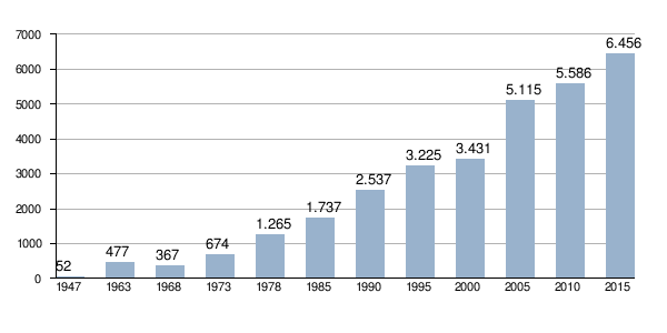
Population development
Kiritimati population development 1947-2015:
Politics and administration
The local affairs of the atoll are regulated by an island council ( Kiritimati Island Council ). With a population of over 5,000, Kiritimati sends three MPs to the Maneaba ni Maungatabu Parliament in South Tarawa . Tawita Temoku , Jacob Teem and Kirata Temamaka were elected for the 10th Parliament 2011–2015 . Jacob Teem and Kirata Temamaka were re-elected to the 11th parliament from 2016 to 2020. Mikarite Temari is a new addition , replacing Temoku.
Economy and Transport
Japanese companies have built a jetty in London to export copra , seaweed and aquarium fish.
Tourist development has started to a lesser extent , mainly anglers and divers . Every now and then a cruise ship moored at Kiritimati.
Since March 28, 1999, the company has carried out Sea Launch launches with the three-stage Zenit 3SL rocket , which is used to launch satellites into geostationary orbit (GTO), where the abbreviation SL stands for Sea Launch. The company is majority owned by the Russian space company RKK Energija . A floating, converted drilling platform that was towed near Kiritimati is used as the launch site. Due to the proximity of the launch site to the equator, a higher payload capacity of the rocket can be achieved.
In the eastern part of the atoll is the small Cassidy International Airport .
Flora and fauna
The island is largely covered with bushes and shrubs, of which Scaevola taccada , Suriana maritima and Sida fallax are the most common. The planted coconut palms ( Cocos nucifera ) can be found in the west. About 20 species of vascular plants are native.
The Polynesian rat ( Rattus exulans ) occurs in native mammals , which is often evidence of an earlier Polynesian settlement. Christmas Island is an important territory with 36 species of seabirds , 18 of which are breeding. With an estimated 15 million seabirds, it is the island with the richest number of individuals on earth. Their respective world's largest population have on Kiritimati the Phoenix Petrel ( Pterodroma alba ) and the wedge-tailed shearwaters ( Puffinus pacificus ), another common seabirds are the Frigate ( Fregata minor ), the Christmas Shearwater ( Puffinus nativitatis ), the masked booby ( Sula dactylatra ), the Red-tailed Tropical bird ( Phaethon rubricauda ) and the spectacled tern ( Onychoprion lunatus ). The rare Fanning warbler ( Acrocephalus aequinoctialis ), which only occurs on Christmas Island and Fanning Island ( Tabuaeran ), should be mentioned among land birds .
On May 29, 1975, before Kiribati gained independence, part of the atoll was placed under nature protection as the Christmas Island Wildlife Sanctuary .
- Sea birds

A not yet fully grown masked booby

Red-footed booby on Tournefortia argentea ( velvet leaf tree)


literature
- Paul Wallin, Helene Martinsson-Wallin: Archaeological Excavations on Christmas Island, the Republic of Kiribati, Central Pacific, August - September 1999. (= Kon-Tiki Field Report Series ; 3). The Kon-Tiki Museum Institute for Pacific Archeology and Cultural History, 2000. ( Online , PDF; 1.09 MB)
Web links
Individual evidence
- ↑ a b c 2015 Population and Housing Census. Volume 1: Management Report and Basic Tables. [Accessed November 22, 2017; PDF; English].
- ↑ a b Report on the Kiribati 2010 Census of Population and Housing. Vol 1: Basic Information and Tables. Appendix 5: Land Area of Islands in Kiribati. S. 227. ( Memento of November 7, 2016 in the Internet Archive ) Retrieved on November 12, 2016 (English).
- ↑ Weatherbase: Historical Weather for London, Kiribati , November 2011. Retrieved September 28, 2013.
- ^ Paul Wallin: Archaeological Excavations on Christmas Island. 2000.
- ^ State Papers , Volume 79, p. 1326.
- ↑ a b c Lorna Arnold: Britain and the H-Bomb . Palgrave Macmillan, New York 2001, ISBN 0-333-94742-8 .
- ↑ Pacific Information Center for Nuclear Tests on the Christmas Islands , Pacific Information Center
- ↑ 2005 census (English)
- ^ Report on the Kiribati 2010 Census of Population and Housing. Vol 1: Basic Information and Tables. Part B: Personal (Population) Tables. Table 3: Population by Village, Sex and Age Group - 2010. P. 50. ( Memento from November 7, 2016 in the Internet Archive ) Accessed on November 12, 2016 (PDF, English).
- ^ Republic of Kiribati: Island Report Series 20: Kirimati. 2012, page 2. [Accessed November 22, 2017; PDF; English].
- ^ Members of the 10th Parliament 2011–2015 ( Memento of March 27, 2012 in the Internet Archive ). Retrieved January 13, 2014.
- ↑ Members of the 11th Parliament 2016-2020. Accessed April 21, 2019 .
- ↑ Wester, Lyndon. 1985. Checklist of the vascular plants of the northern Line Islands. Smithsonian Institution, Washington. Atoll Research Bulletin 287: 1-38 (PDF (8 MB), English)

Northern group:
Kingman attack |
Kiritimati |
Palmyra Atoll |
Tabuaeran |
Teraina
Central group:
Filippo Reef |
Jarvis |
Malden |
Starbuck
Southern group:
Flint |
Millennium Island |
Vostok
Gilbert Islands : Abaiang | Abemama | Aranuka | Arorae | Beru | Butaritari | Kuria | Maiana | Makin | Marakei | Nikunau | Nonouti | Onotoa | Tabiteuea | Tamana | Tarawa
Line Islands : Caroline | Flint | Kiritimati | Malden | Starbuck | Tabuaeran | Teraina | Vostok
Phoenix Islands : Birnie | Enderbury | Canton | Manra | McKean | Nikumaroro | Orona | Rawaki
another island: Banaba