Banaba
| Banaba | |
|---|---|
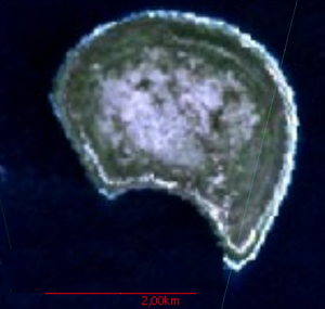
| Banaba satellite image | |
| Waters | Pacific Ocean |
| Geographical location | 0 ° 51 '34 " S , 169 ° 32' 13" E |
| length | 3.5 km |
| surface | 6.29 km² |
| Highest elevation | 81 m |
| Residents | 268 (2015) 43 inhabitants / km² |
| main place | Antereen |
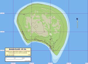
| Map of Banaba | |
Banaba , formerly called Ocean Island , is an island in the Pacific Ocean belonging to the island republic of Kiribati . Along with Nauru, it represented one of the most important phosphate deposits in the Pacific.
geography
Banaba is comparatively isolated around 430 km southwest of the Gilbert Islands and 290 km east of Nauru . It is an upscale atoll with a diameter of about 3.5 km and an area of 6.29 km². The outer coral ring of the island reaches a height of up to 81 m above sea level and thus represents the highest point in Kiribati.
Around 300 people live on the island and are spread over four villages; The main town is Antereen, the former Tabiang.
| Village | Population ( census ) | |||
|---|---|---|---|---|
| 1995 | 2005 | 2010 | 2015 | |
| Tabiang (Antereen) | 16 | 108 | 83 | 102 |
| Uma (Umwa, Ooma) | 269 | 135 | 155 | - |
| Tabwewa (Tabewa, Tapiwa) | 54 | 58 | 57 | 166 |
| Buakonikai | - | - | - | - |
| Banaba | 339 | 301 | 295 | 268 |
history
Pre-colonial history
According to the oral tradition of the residents of Banaba, the island was settled in three waves. The first settlement was made by the Melanesian clan of the Te Aka , who probably came from the Banks Islands . In the 16th century , a second clan named Auriaria settled the island. The origins of this clan are believed to be on the island of Halmahera , which is now part of Indonesia . In the 17th century Gilbertese finally settled from the island of Beru on Banaba.
European Discovery and Colonialism
On January 3rd, 1801, the island was first sighted by a European by the captain of the American ship Diana , Jared Gardner. At first he thought the island was Nikunau, about 770 km to the east . After realizing he had discovered a new island, he eventually named it Rodman's Island . In 1804 the captain John Mertho of the British ship Ocean accidentally sighted the island and named it Ocean Island . But the community of inhabitants, which was made up of different people from the Pacific region, remained of no interest to the colonial powers. In 1900, however, they discovered that the entire rock consisted of petrified bird droppings ( guano ), thus almost exclusively of phosphate .
Banaba was next to Nauru the second island in the western Pacific on which large phosphate deposits were detected. In 1901 the British occupied the island, annexed it and assigned it to their colony of Gilbert and Ellica islands . Banaba was named Ocean Island . The Pacific Islands Company from Sydney immediately began mining the raw material, for which there was enormous demand as fertilizer in Australia and New Zealand. The 3 km long Ocean Island Railway was built for transport to the port . The Pacific Islands Company legitimized itself with an agreement with the King of Banaba . He leased them the mining rights for 999 years at a price of 50 pounds a year. However, a feudal system never existed on Banaba, nor was there a king who could have made such promises.
Japanese rule during World War II
With 500 soldiers and half a hundred forced laborers , Japan occupied the island on August 24, 1943 during the Pacific War . While the British had already evacuated all but five Europeans and the approximately 800 Chinese workers of the company, they left the approximately 700 locals and another 713 migrant workers on the island. 349 did not survive the terror regime that followed. “ Shootings , beatings with wooden sticks, torture with electric shocks and rape were the order of the day. The Japanese imposed the death penalty even for the smallest "offenses" such as picking a coconut . Parents cut their heads off in front of their children. "
The surviving miner Tikaouti Bonabati from the Gilbert Islands said: “ It would have been better to be a soldier than a captured civilian. Soldiers have weapons and thus a chance. We had none. We were slaves and they treated us like pigs. Human rights did not apply to us. “Ituaso Lafai reports the beheading of two men from the Gilbert Islands, where all residents had to be present. The occasion was the theft of a handful of rice .
In mid-August 1945 the Japanese kidnapped all but 150 young male residents in a nightly action in a Pacific labor camp. It was very likely August 20, 1945, when the Japanese took the remaining residents to a cliff near the village of Tabiang, blindfolded them and, according to a UNESCO report, committed a massacre of 143 Banabars.
On October 1, 1945, the Allies landed on the island. The Japanese stated that all residents had been evacuated. It was not until the beginning of December that the 28-year-old Kabunare from Nikunau was discovered as the only survivor of the massacre and was able to report on the atrocity. The massacre was dealt with under the Australian-directed war crimes trials in New Guinea .
The British refused to return the island to the 1,003 residents of the island, who had survived the suffering mainly in Japanese labor camps until the end of 1945. They were brought to Rabi , a Fiji island 2,500 kilometers away .
Kiribati suzerainty after World War II
Only after political protests in 1979 were the residents able to return to their homeland, which had been completely destroyed by British phosphate mining.
In the meantime, some Banabans returned to the island, but about half of them emigrated to Rabi again in 1999/2000. Attempts to separate Banaba from Kiribati as an independent state have so far failed.
literature
- Katerina Martina Teaiwa: Consuming Ocean Island. Stories of People and Phosphate from Banaba. Indiana University Press, Bloomington, Indiana, 2015, ISBN 978-0-253-01460-3 . Detailed online preview
- Raobeia Ken Sigrah , Stacey M. King: Te rii ni Banaba. Institute of Pacific Studies, University of the South Pacific, Suva, Fiji 2001, ISBN 982-02-0322-8 (bibliography pp. 312-316). Detailed online preview
- Henry Evans Maude : The book of Banaba. From the Maude and Grimble papers and published works. Edited by HC and HE Maude. Institute of Pacific Studies, University of the South Pacific, (Suva) 1994, ISBN 0-646-20128-X .
- Martin G. Silverman: The Resettled Banaban (Ocean Island) Community in Fiji: A Preliminary Report In: Current Anthropology . Vol. 3, No. 4 (Oct. 1962), pp. 429-431.
- RN Posnett: Ocean Island and the Banabans. A report to the Minister of State for Foreign and Commonwealth Affairs. 1978 ( Memento of March 31, 2011 in the Internet Archive ) (PDF; 4.1 MB), English.
- Our victims don't count: the Third World in World War II. Rheinisches Journalistinnenbüro (RJB), Berlin 2005, ISBN 3-935936-26-5 .
Web links
- Website Banaba and Rabi (English)
- Banaba on www.janeresture.com (English)
- Kiribati Climate Change: Banaba Island Reports (PDF)
Individual evidence
- ^ Population and No of Households by Island: 2010, 2015. Population and Housing Census, 2015.
- ^ Report on the Kiribati 2010 Census of Population and Housing. Vol 1: Basic Information and Tables. Appendix 5: Land Area of Islands in Kiribati. S. 222. ( Memento of the original from November 7, 2016 in the Internet Archive ) Info: The archive link was automatically inserted and not yet checked. Please check the original and archive link according to the instructions and then remove this notice. Retrieved November 12, 2016.
- ↑ 2005 census (English)
- ^ Report on the Kiribati 2010 Census of Population and Housing. Vol 1: Basic Information and Tables. Part B: Personal (Population) Tables. Table 3: Population by Village, Sex and Age Group - 2010. P. 34. ( Memento of the original from November 7, 2016 in the Internet Archive ) Info: The archive link was automatically inserted and not yet checked. Please check the original and archive link according to the instructions and then remove this notice. Retrieved November 12, 2016.
- ^ Population and No of Households by Island: 2010, 2015. Population and Housing Census, 2015.
- ↑ For all quotations see: Our victims don't count: the Third World in World War II. RJB, Berlin 2005.


