
Rabi (Fiji)
| Rabi | ||
|---|---|---|
 |
||
| Waters | Pacific Ocean | |
| Archipelago | Fiji | |
| Geographical location | 16 ° 30 ′ S , 179 ° 58 ′ W | |
|
||
| length | 13 km | |
| width | 8 kilometers | |
| surface | 66.3 km² | |
| Highest elevation | Delairabe ( Mt.Banaba ) 463 m |
|
| Residents | 5000 75 inhabitants / km² |
|
| main place | Tabwewa (Nuku) | |

Rabi (pronunciation [ rambi ], also [ rampi ]), formerly also spelled Rambi , is an island of the island state of Fiji in the southern Pacific Ocean and is administratively part of the Northern Division , specifically the province of Cakaudrove . The island is best known for its Gilbertese population, who were forcibly resettled from Banaba .
geography
The island is less than four kilometers east of the large Tunuloa Peninsula of Vanua Levu , the second largest island in Fiji, and 20 kilometers north of Taveuni Island . Rabi is about 13 km long, up to 8 km wide and has an area of 66 km². Rabi is of volcanic origin, hilly and in Delairabe (Mt. Banaba) reaches a height of up to 463 m above sea level.
Rabi has four main settlements, which are named after the former villages on Banaba that were destroyed in World War II: The administrative center Tabwewa , former Fijian name Nuku , in the northwest of the island, with a shipyard, post office and hospital; 4 km south of Uma , formerly Wiinuku ; Tabiang , former Fijian name Siosio , with the only school and runway in the far southwest; and Buakonikai , formerly Aoteqea , on the south coast.
cards

Banaba 1936 with the four original villages

Rabi with the villages named after them, with their original names
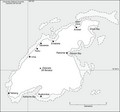
Map of Rabi


literature
- Raobeia Ken Sigrah , Stacey M. King: Te rii ni Banaba. Institute of Pacific Studies, University of the South Pacific, Suva, Fiji 2001, ISBN 982-02-0322-8 (bibliography pp. 312-316). Detailed online preview
- Henry Evans Maude : The book of Banaba. From the Maude and Grimble papers and published works. Edited by HC and HE Maude. Institute of Pacific Studies, University of the South Pacific, (Suva) 1994, ISBN 0-646-20128-X .
- Martin G. Silverman: The Resettled Banaban (Ocean Island) Community in Fiji: A Preliminary Report In: Current Anthropology Volume 3, No. 4, 1962, pp. 429-431.
- RN Posnett: Ocean Island and the Banabans. A report to the Minister of State for Foreign and Commonwealth Affairs. 1978 ( Memento of March 31, 2011 in the Internet Archive ) (PDF; 4.1 MB).
- Teresia K. Teaiwa : Peripheral visions? Rabi Island in Fiji's general election (PDF; 961 kB). In: Brij V. Lal (Ed.): Fiji before the storm. Elections and the politics of development. Asia Pacific Press, Canberra 2000, ISBN 0-7315-3650-9 , pp. 93-109. ( Online )
Web links
- Banaba semi-official website for Banaba and Rabi (English, parts also in German). Accessed May 14, 2010.
- Banaba on www.janeresture. com rev. 16th January 2009. Background information and pictures about Banaba and Rabi (English). Accessed May 14, 2010.
- Map of Rabi Accessed November 10, 2014.
Individual evidence
- ↑ a b UNEP Islands