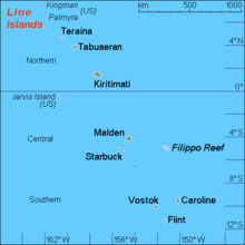
Line Islands
| Line Islands | |
|---|---|
| Location of the Line Islands (right) in the Pacific | |
| Waters | Pacific Ocean |
| Geographical location | 4 ° 0 ′ S , 154 ° 58 ′ W |
| Number of islands | 11 |
| Main island | Kiritimati |
| Total land area | 503.91 km² |
| Residents | 10,483 (2015) |
The Line Islands , on German also Zentralpolynesische Sporades , Line Islands or Line Islands called, are a chain of islands in the eastern central Pacific with eight atolls , three individual islands and a flooded coral reef . The total land area of the islands is almost 504 km².
history
The first island was discovered by James Cook on December 24, 1777 and named "Christmas Island" (now Kiritimati ), and Malden Island was the last of the islands to be sighted in 1825 . Most of the Line Islands were repossessed for the United States under the Guano Islands Act , passed in 1856 ; the Kingman attack , Jarvis Island and the Palmyra Atoll are still owned by the United States today and each represent an outer area of the United States . The other islands were initially British territory since 1888 and became part of the island state of Kiribati in 1979 .
population
At the time of discovery by Europeans, the Line Islands did not have an indigenous population, but evidence of early Polynesian settlement was found. For the production of copra , Micronesian residents were relocated from the Gilbert Islands to the Line Islands since the beginning of the 20th century . Today, according to the 2015 census (2010: 9236) , three islands (they were given Gilbertese names) are permanently inhabited by a total of 10,483 people and are governed by island councils. A research station with changing staff is located on the Palmyra Atoll.
geography
The Line Islands form a 2334 km (as the crow flies - Kingman Reef to Flint Island) long, northwest to southeast stretched island chain, which begins 718 km north of the equator and ends 1273 km south of the equator.
The line islands include from north to south:
![]() Map with all coordinates: OSM | WikiMap
Map with all coordinates: OSM | WikiMap
Since the date line has its easternmost position here, the New Year is celebrated first on the Line Islands, more precisely on the Caroline Atoll , according to the Gregorian calendar. The Caroline Atoll is now called Millennium Atoll and the main island Long Islet of the Caroline Atoll has been called Millennium Island since 2001, because the first sunrise of the 21st century or the 3rd millennium took place on January 1st, 2001.
Flora and fauna
Since the islands are comparatively isolated, they are an important refuge for sea birds . Some of the world's largest bird colonies are located on the Line Islands, especially on Palmyra ( red-footed booby ), Kiritimati ( wedge-tailed shearwater ) and Starbuck ( black tern ). Land birds such as the rare, endemic Fanning Warbler are also found . The palm thief , a type of cancer, also has its largest populations worldwide here . Mammals include the Polynesian rat , which was probably brought to some of the Line Islands by Polynesian settlers. However, through the mining of guano , the planting of coconut palms and the introduced mammals, the native animal and plant species were caused great damage; For example, there are only a few original forests of Pisonia trees left. Apart from the Kingman attack, which barely rises above sea level, only the island of Vostok has an almost pristine nature. Many of the islands belonging to Kiribati have been declared a wildlife sanctuary by the United Nations , while the American-owned islands are part of the Pacific Island Wildlife Refuges and are managed by the US Fish & Wildlife Service .
See also
Web links
- Historical information on the Line Islands (English)
- Maps of the Line Islands (English)
- Islands (English) WWF
Individual evidence
- ↑ a b 2015 Population and Housing Census. Volume 1. Bairiki, September 2016. (PDF; 2.8 MB). Accessed November 23, 2017.


