
Tabuaeran
| Tabuaeran | ||
|---|---|---|
 |
||
| Waters | Pacific Ocean | |
| archipelago | Line Islands | |
| Geographical location | 3 ° 52 ′ N , 159 ° 22 ′ W | |
|
||
| Number of islands | > 12 | |
| Main island | Motu o dew | |
| Land area | 33.7 km² | |
| Lagoon area | 110 km² | |
| Highest elevation | 4 m | |
| Residents | 2315 (2015) | |

Tabuaeran , also Fanning Island , is an atoll in the north of the Line Islands south of Hawaii and belongs to the Pacific island state of Kiribati .
geography
The atoll was originally named after its American explorer Edmund Fanning (1769–1841). It consists of three larger islands and numerous other small islets ( motus ). The oval lagoon can be navigated by small ships through a passage to the west (English Harbor) . Around 2500 people live in nine settlements on a land area of 33.7 km². All settlements are along the west and south-west coasts of the atoll. The highest point is currently 4 m above sea level.
The inhabitants of Tabuaeran are predominantly Micronesians , who were brought from the Gilbert Islands by Fanning Island Plantations Ltd. settled as workers for the copra industry at the beginning of the 19th century. The administrative seat is in Paelau (Napia) in the northwest.
The individual settlements (from north to south)
|
||||||||||||||||||||||||||||||||||||||||||||||||

history
With a distance of around 1,450 km from the Hawaiian Islands, Tabuaeran is a possible stopover for Polynesian settlers en route to Hawaii. Objects have been found that suggest early Polynesian colonization , possibly from the Cook Islands or Tonga . When Captain Edmund Fanning discovered the islands for the United States on November 6, 1798 with the ship Betsy , they were uninhabited like the other atolls of the Line Islands.
Fanning was first claimed by the US in 1800 and annexed by the United Kingdom in 1889 . The British set up a cable station for their transpacific cable, which was damaged in 1914 by the German cruiser Nürnberg . In 1939 the atoll became part of the British colony of the Gilbert and Ellice Islands and in 1979 with the independence of the colony part of the Republic of Kiribati .
Picture gallery
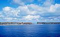
The entrance to the lagoon in the west of the atoll ( English Channel )

A coconut grove on Tabuaeran

Locals with an outrigger canoe

A sandbar with coral limestones


Web links
- Entry on oceandots.com ( Memento from December 23, 2010 in the Internet Archive ) (English)
- Description with photos (English)
- map
Individual evidence
- ^ A b Population and No of Households by Island: 2010, 2015. Population and Housing Census, 2015. Retrieved May 16, 2018.
- ↑ 2005 census (PDF, English)
- ^ Report on the Kiribati 2010 Census of Population and Housing. Vol 1: Basic Information and Tables. Part B: Personal (Population) Tables. Table 3: Population by Village, Sex and Age Group - 2010. p. 50. ( Memento of the original from November 7, 2016 in the Internet Archive ) Info: The archive link was inserted automatically and has not yet been checked. Please check the original and archive link according to the instructions and then remove this notice. Retrieved November 12, 2016.

Northern group:
Kingman attack |
Kiritimati |
Palmyra Atoll |
Tabuaeran |
Teraina
Central group:
Filippo Reef |
Jarvis |
Malden |
Starbuck
Southern group:
Flint |
Millennium Island |
Vostok
Gilbert Islands : Abaiang | Abemama | Aranuka | Arorae | Beru | Butaritari | Kuria | Maiana | Makin | Marakei | Nikunau | Nonouti | Onotoa | Tabiteuea | Tamana | Tarawa
Line Islands : Caroline | Flint | Kiritimati | Malden | Starbuck | Tabuaeran | Teraina | Vostok
Phoenix Islands : Birnie | Enderbury | Canton | Manra | McKean | Nikumaroro | Orona | Rawaki
another island: Banaba