
Marakei
| Marakei | ||
|---|---|---|
 |
||
| Waters | Pacific Ocean | |
| archipelago | Gilbert Islands | |
| Geographical location | 2 ° 1 ′ N , 173 ° 17 ′ E | |
|
||
| Number of islands | 11+ | |
| Land area | 14.1 km² | |
| Lagoon area | 24.86 km² | |
| Residents | 2872 (2010) | |

Marakei , formerly: Metthew Island or Maraki , is a small atoll in the northern part of the Gilbert Islands archipelago . It is located northeast of the main atoll, Tarawa .
geography
The central lagoon of the atoll consists of many deep basins and is enclosed by two islands, which are only separated from each other by two narrow channels. The two channels ( Baretoa Pass and Reweta Pass ) are so shallow that they can be passed at low tide . The islands of the atoll cover an area of 14.1 km², the central lagoon 24.86 km².
The main town is Rawannawi . At the northern tip of the atoll is the Marakei airfield .
population
Demographic statistics
| settlement | 1978 | 2005 | 2010 |
|---|---|---|---|
| Rawannawi | 1075 | 1000 | |
| Temotu | 116 | 164 | |
| Buota | 259 | 339 | |
| Tekarakan | 362 | 358 | |
| Bwainuna | 246 | 310 | |
| Norauea | 311 | 321 | |
| Tekuanga | 207 | 217 | |
| Antai | 165 | 163 | |
| total | 2335 | 2741 | 2872 |
Population development
| census | 1931 | 1947 | 1963 | 1968 | 1973 | 1978 | 1985 | 1990 | 1995 | 2000 | 2005 | 2010 |
|---|---|---|---|---|---|---|---|---|---|---|---|---|
| total | 1803 | 2213 | 2180 | 2212 | 2335 | 2693 | 2863 | 2724 | 2544 | 2741 | 2872 |
Culture

A maneaba (meeting house)
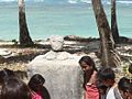
One of four shrines


Web links
Individual evidence
- ↑ a b Report on the Kiribati 2010 Census of Population and Housing. Bairiki, August 2012, Volume 1, p. 31. ( Memento of the original dated November 7, 2016 in the Internet Archive ) Info: The archive link was inserted automatically and has not yet been checked. Please check the original and archive link according to the instructions and then remove this notice. (PDF; 6.6 MB). Retrieved November 12, 2016.
- ^ Report on the Kiribati 2010 Census of Population and Housing. Bairiki, August 2012, Volume 1, p. 223. ( Memento of the original dated November 7, 2016 in the Internet Archive ) Info: The archive link was inserted automatically and has not yet been checked. Please check the original and archive link according to the instructions and then remove this notice. (PDF; 6.6 MB). Retrieved November 12, 2016.
- ^ Report of the 1978 Census of Population and Housing. Republic of Kiribati 1980 , Vol. 1 (Time of Independence)
- ↑ Kiribati 2005 Census of Population and Housing. Provisional tables. (Accessed March 29, 2010)
- ^ Report on the Kiribati 2010 Census of Population and Housing. Bairiki, August 2012, Volume 1, p. 35. ( Memento of the original from November 7, 2016 in the Internet Archive ) Info: The archive link was automatically inserted and not yet checked. Please check the original and archive link according to the instructions and then remove this notice. (PDF; 6.6 MB). Retrieved November 12, 2016.
- ^ Henry Evans Maude : Report on the 1931 Census of the Gilbert, Ellice and Phoenix Islands. Western Pacific High Commission , Suva 1932. Information for 1931 also in: Rural socio-economic change in the Gilbert and Ellice islands. 1979, p. 19.
- ↑ Kiribati: 2005 Census. Vol. 2: Analytical Report. 2007 ( Memento of the original from January 13, 2014 in the Internet Archive ) Info: The archive link was inserted automatically and has not yet been checked. Please check the original and archive link according to the instructions and then remove this notice. Final Report, p. 104 (for the years 1947-2005) (Retrieved April 17, 2010)
Gilbert Islands : Abaiang | Abemama | Aranuka | Arorae | Beru | Butaritari | Kuria | Maiana | Makin | Marakei | Nikunau | Nonouti | Onotoa | Tabiteuea | Tamana | Tarawa
Line Islands : Caroline | Flint | Kiritimati | Malden | Starbuck | Tabuaeran | Teraina | Vostok
Phoenix Islands : Birnie | Enderbury | Canton | Manra | McKean | Nikumaroro | Orona | Rawaki
another island: Banaba