Butaritari
| Butaritari | ||
|---|---|---|
| Satellite image of Butaritari, post-processed | ||
| Waters | Pacific Ocean | |
| archipelago | Gilbert Islands | |
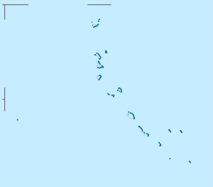
| Geographical location | 3 ° 10 ′ N , 172 ° 50 ′ E | |
|
|
||
| Number of islands | 11+ | |
| Main island | Butaritari | |
| length | 30 km | |
| width | 15 km | |
| Land area | 13.49 km² | |
| Lagoon area | 295.77 km² | |
| Residents | 4346 (2010) | |
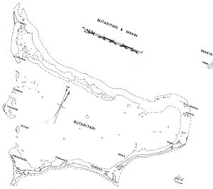
| The Butaritari Atoll and part of Makin (top right) | ||
Butaritari is an atoll in the Pacific Ocean that geographically belongs to the Gilbert Islands and politically to the state of Kiribati . Makin , the closest atoll, is three kilometers to the northwest .
geography
The entire Butaritari Atoll was named Makin Atoll by the American military command during the Second World War during the Pacific War . The neighboring Makin archipelago was then called Makin Meang or Little Makin to distinguish it .
Butaritari has a land mass of 13.49 km². The lagoon measures 295.77 km². It extends over 30 km from east to west and around 15 km from north to south.
Butaritari Island
The eponymous main island is located on the southern reef edge of the atoll. It runs from Flink Point ( ⊙ , Tabononibi / Taboshonnobi Point) at its northwestern end, initially south to Ukiangang Point ( ⊙ ). The place of the same name is also located there. At the same time, however, the main arm of the reef stretches to the northeast, so that this end of the island forms a triangular base. The place Tabonuea ( ⊙ ) is then approximately in the middle of the elongated island with the Butaritari Airfield . From there the reef crest pulls straight east to the end at Tabukintetau ( ⊙ ) at Tanimainiku Village . This end of the island is heavily divided by shallow bays. The Keueva Causeway ( ⊙ ) connects the island with the apparently unnamed neighboring island in the northeast and their localities Keuea and Kuma .
population
According to the 2010 census, 4,346 people live on Butaritari , who make up 4.2% of the Kiribati population.
Demographic statistics
| census | 1978 | 2005 | 2010 |
|---|---|---|---|
| Kuma / Kuuma | 401 | 635 | 323 |
| Keuea | 188 | 221 | 258 |
| Tanimainiku | 219 | 229 | 248 |
| Tanimaiaki | 284 | 250 | 267 |
| Tabonuea | 204 | 244 | 271 |
| Butaritari | 1233 | - | - |
| Antekana | - | 161 | 217 |
| Taubukinmeang | - | 266 | 835 |
|
Temanokunuea / Temwanokunuea
(Main place) |
- | 386 | 621 |
| Onomaru | - | 347 | 366 |
| Ukiangang | 503 | 338 | 707 |
| Bikati / Bikaati | 117 | 203 | 225 |
| Ticurere | - | - | 8 |
| total | 3149 | 3280 | 4346 |
Population development
| census | 1931 | 1947 | 1963 | 1968 | 1973 | 1978 | 1985 | 1990 | 1995 | 2000 | 2005 | 2010 |
|---|---|---|---|---|---|---|---|---|---|---|---|---|
| total | 1673 | 1824 | 2611 | 2714 | 2971 | 3149 | 3622 | 3774 | 3909 | 3464 | 3280 | 4346 |
history
Discovery story
Butaritari was first sighted in 1606 by the Portuguese explorer Pedro Fernández de Quirós before Captains John Marshall on Scarborough and Captain Thomas Gilbert on Charlotte touched the northern Gilbert Islands in 1788.
Pacific War
In the Pacific War , the atoll was occupied by Japanese troops immediately after the start of the war on December 10, 1941 , who tried to "liberate" the population from British colonial power and to establish self-government for the inhabitants under Japanese rule, which, however, met with strong rejection. The atoll would then become one of the primary targets of the American advance in 1942 into the Central Pacific. The Marine Raiders , an elite unit of the US Marine Corps , took the atoll with 220 men on August 17, 1942. Of the 70 Japanese stationed, half fell. But since the US troops withdrew again the next day, the Japanese succeeded in reoccupying the entire Gilbert Islands in 1943 and building a base for seaplanes on Makin . From 20 to 24 November 1943 landed parts of the 27th Infantry Division in the Battle of Makin that are part of Operation Galvanic , was on Makin and the Japanese defeated there. In February 1944, the atoll was used as a starting point together with the air force bases on Abemama and Tarawa for the attacks on the Marshall Islands .
Modern times
The local issues are regulated by an island council ( Butaritari Island Council ), based in the main town Temanokunuea.
Butaritari sends two members of parliament to the Maneaba ni Maungatabu parliament in South Tarawa , Alexander Teabo and Tinian Heron were elected for the 10th parliament 2011–2015 .
Culture
The I-Butaritari and the I-Makin speak a dialect of Kiribati , which differs in its harder pronunciation (e.g. Pu-täri-täri for Butaritari) and other word meanings from those in the central and southern Gilbert Islands.
traffic
Butaritari can be reached from the air via Butaritari Atoll Airport and is served by the state airline Air Kiribati . The flight time is about 30 minutes.
There is shipping traffic via the main Kiribati port in Betio on South Tarawa , as larger ships can moor in Butaritari through the deep lagoon.
literature
- Betsy Sewell: Butaritari report. In: Rural socio-economic survey of the Gilbert and Ellice Islands. Team report. Victoria University of Wellington, Department of Geography, Wellingen 1979.
- Bernd Lambert: A Gilbertese word list (Butaritari-Makin dialect). 1959-61.
- Bernd Lambert: Uean abara. The High Chiefs of Butaritari and Makin as kinsmen and office-holders. In: The changing Pacific. Papers in Honor of HE Maude . Oxford University Press, Melbourne 1978, pp. 80-93.
- A. Binion Amerson, Jr .: Ornithology of the Marshall and Gilbert Islands. (PDF; 9.0 MB) Atoll Research Bulletin. Vol. 127, 1969.
Web links
- Butaritari Island Report 2012. Office of the Beretitenti, Republic of Kiribati Island Report Series: 2. Butaritari. Accessed January 13, 2014
- Butaritari ( Memento from December 23, 2010 in the Internet Archive ) on oceansdot.com . Retrieved April 22, 2010 (English)
- Butaritari on janeresture.com . Illustrated information on history and culture. Retrieved April 22, 2010 (English)
Individual evidence
- ↑ a b Report on the Kiribati 2010 Census of Population and Housing. Volume 1. Bairiki, August 2012, p. 31 ( Memento from November 7, 2016 in the Internet Archive ) (PDF; 6.6 MB). Retrieved November 12, 2016.
- ^ Report on the Kiribati 2010 Census of Population and Housing. Volume 1. Bairiki, August 2012, p. 222. ( Memento from November 7, 2016 in the Internet Archive ) (PDF; 6.6 MB). Retrieved November 12, 2016.
- ↑ Butaritari Island Report 2012, p. 5 . Retrieved January 13, 2014.
- ↑ Former information also: 191.7 km², source: Atoll Research Bulletin , vol. 127 (1969), p. 211: 74 square miles . (PDF; 9.0 MB).
- ↑ geonames.org .
- ^ Report of the 1978 Census of Population and Housing. Republic of Kiribati 1980. Volume 1, pp. 2-3 (date of independence).
- ↑ Kiribati 2005 Census of Population and Housing. Provisional tables. Retrieved March 29, 2010 (English).
- ^ Report on the Kiribati 2010 Census of Population and Housing. Volume 1. Bairiki, August 2012, pp. 34-35. ( Memento of November 7, 2016 in the Internet Archive ) (PDF; 6.6 MB). Retrieved November 12, 2016.
- ^ Henry Evans Maude : Report on the 1931 Census of the Gilbert, Ellice and Phoenix Islands. Western Pacific High Commission , Suva 1932. Information for 1931 also in: Rural socio-economic change in the Gilbert and Ellice islands. 1979, p. 19.
- ↑ Kiribati: 2005 Census. Volume 2: Analytical Report. 2007 ( Memento of the original from January 13, 2014 in the Internet Archive ) Info: The archive link was inserted automatically and has not yet been checked. Please check the original and archive link according to the instructions and then remove this notice. Final Report, p. 102 (for the years 1947-2005). Retrieved April 17, 2010
- ↑ Celsus Kelly: La Austrialia del Espiritu Santo. The Journal of Fray Martín de Munilla OFM and other documents relating to the Voyage of Pedro Fernández de Quirós to the South Sea (1605-1606) and the Franciscan Missionary Plan (1617-1627). Cambridge 1966, pp. 39, 62.
- ^ Members of the 10th Parliament 2011–2015 ( Memento of March 27, 2012 in the Internet Archive ). Retrieved January 13, 2014.


