
Betio
| Betio | ||
|---|---|---|
 |
||
| Waters | Pacific Ocean | |
| Archipelago | Tarawa | |
| Geographical location | 1 ° 21 '23 " N , 172 ° 55' 54" E | |
|
||
| length | 4.4 km | |
| width | 1.2 km | |
| surface | 1.67 km² | |
| Residents | 17,330 (2015) 10,377 inhabitants / km² |
|
| main place | Betio | |
 |
||

Betio [ ˈbeso ] is an island and at the same time a place with around 17,000 inhabitants (as of 2015) in the southwest of Tarawa , an atoll in the Pacific Ocean, and belongs to the island state of Kiribati . The island is known as the "main gate" of Tarawa and is also home to the port of the atoll. The island forms the Betio Town Council (BTC) .
history
In the time before contact with Europeans, the island was divided into eight kaingas , each of which comprised part of the mainland and adjacent sea area. The population of a Kainga was up to 12 households, with an average household size of 6. The border to the nearest island of Bairiki in the east was formed by the reef Nei Teba .
Betio became famous for being the site of the Battle of Tarawa . There are still numerous wrecks in the reefs of the island today . In the 1970s, the small island experienced an economic boom and was the "center" of Kiribati's economy. Betio was considered the most densely populated square in the world in the 1980s. The population according to the 1978 census of 7626 already meant a population density of 4566 Ew / km².
Connections to the outside world
Betio has a navigable dam that leads to Bairiki . In addition, the port of the island state is on Betio.
Offices
The following authorities, among others, have their seat on the island of Betio: Office of Tourism, Office of Commerce, Customs Office, Supreme Court (Kiribati High Court), Port Authority (Kiribati Port Authority) and the Police Headquarters.
Historical maps
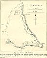
World War II map of Tarawa Atoll
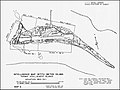
Map of Betio from World War II


Individual evidence
- ↑ 2015 Population and Housing Census. Volume 1. Bairiki, September 2016. (PDF; 2.8 MB). Accessed November 23, 2017.